Is ArcGIS Managed Cloud Services the right fit for you?
Following Esri Canada’s new ArcGIS Managed Cloud Services launch, this blog answers some of the key questions you have regarding Canadian data residency, setup, security, and how we keep your environment updated and monitored so your team can focus on delivering results.
Earlier this year, we announced the official launch of Esri Canada’s ArcGIS Managed Cloud Services (MCS) offering. Our goal was to address the increasing demand from Canadian organizations that were looking to offload the stress and strain of having their team get tied up on administrative duties rather than focusing on the work that truly matters. But as with any important decision, you may be wondering whether a managed cloud service is the right fit for your needs. I have written this blog to help answer some of the common questions we have heard to help make the decision a little easier.
Where will my data be hosted?
Short answer: Canada. Longer answer: For Esri Canada ArcGIS Managed Cloud Services, data is stored within Canada by default. However, Esri Canada is flexible if you choose to store data elsewhere. Furthermore, Esri Canada is a Canadian company that operates as an independent business under Canadian laws, serving Canadian customers and employing Canadian staff for over 40 years.
What’s the process like to get set up on Managed Cloud Services?
It’s important that MCS is a correct fit. This is why, before a firm proposal is even put forward, we sit down with your team and do an architecture review. If the right requirements are in place, then we will jointly work out a proposal. Once everything is signed off, we kick off the relationship with a walkthrough on the environment, which is then validated and signed off before going live. And for those of you under a time crunch to get new products or services launched — we can get your environment set up in a matter of weeks, not months.
Will the environment be secure?
From design to delivery, security is baked into everything we do here at Esri Canada. This is why MCS is ISO 27001, ISO 27017 and ISO 27018 certified and is compliant with globally recognized standards for system security, cloud security and data privacy. The International Organization for Standardization (ISO) is an independent, non-governmental organization that sets international standards for ensuring products and services are safe, reliable and high quality. Of note are the ISO 27017 and ISO 27018 certifications which are directly related to cloud computing environments. Together they cover the protection of personally identifiable information (PII) and address specific security risks associated with cloud computing by setting strict regulations covering everything from roles and responsibilities to virtual machine configuration. You can learn more about MCS’ security by visiting this page.
Are you replacing my staff?
No, we are an extension of the team you have. Many IT and GIS teams would agree that they’re feeling overworked and at capacity. It’s no surprise; research released just this year by Robert Half found that only 5 per cent of leaders reported having the necessary headcount and skill sets to accomplish priority projects in 2026. Furthermore, the same study found that 50 per cent of tech leaders said that finding skilled talent is more difficult today than a year ago. The fact of the matter is that IT teams are looking for opportunities to offload mundane management and daily tasks in favour of focusing on high-priority tasks and overall strategy.
Our offering addresses this need.
We take the day-to-day management off your hands, we also handle updates, backups and the critical tasks associated with hosting ArcGIS on the cloud. We also have the necessary licensing and security framework — something that can have huge costs and skill requirements to do in-house. Furthermore, our teams are already comprised of ArcGIS, cloud, security, network and managed services architects, and experts. This means you can rely on us to perform routine patches and security updates, all with timely warnings ahead of release so your team is prepared.
Should you have specific requests, we are on standby to scope it out as an add-on and rapidly deploy. We take on the burden of administration so your team is freed up to focus on your priorities.
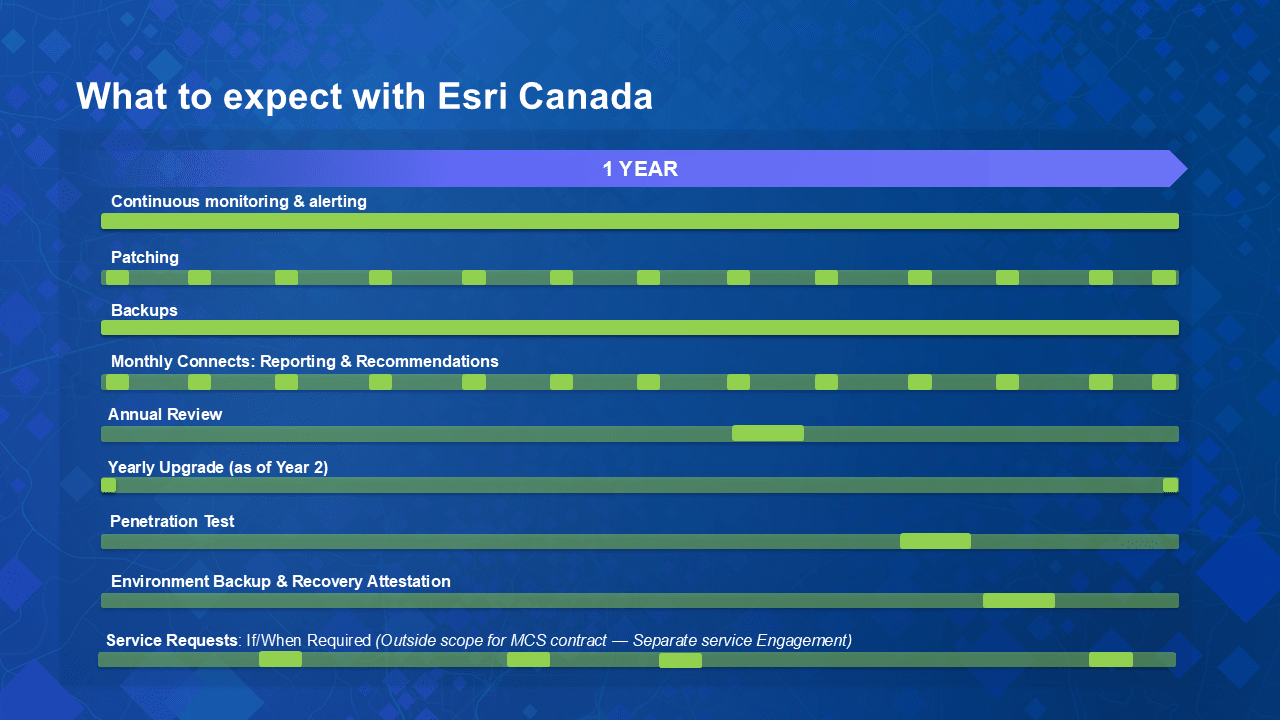
A snapshot of a typical year with Esri Canada ArcGIS Managed Cloud Services
Why should I do this now?
Keeping systems patched and up to date has never been more critical. Ransomware is rising across Canadian municipalities, yet the MNP 2025 Municipal Report found that 43 per cent still cite legacy technology as a major barrier. Outdated systems and deferred updates create vulnerabilities that can lead directly to security incidents or slow recovery when one occurs.
And it is not just governments at risk. Businesses face the same threats, often with significant financial consequences. In 2025, the average cost of a data breach in Canada reached $4.84 million USD. Having the capacity to consistently update and manage applications and systems is no longer optional.
At the same time, teams are already stretched thin. MCS takes over that responsibility. MCS helps your team stay secure and current now, so you are not forced to deal with larger challenges later.
If you have questions or feedback to share, we’d be happy to hear from you. Reach out anytime using our contact form.