Third Version’s the Charm: NG9-1-1 GIS Data Model FAQ
A FAQ for the Newly Published Version of the NG9-1-1 GIS Data Model.
View
A FAQ for the Newly Published Version of the NG9-1-1 GIS Data Model.
View
What emails would you like to receive from us?
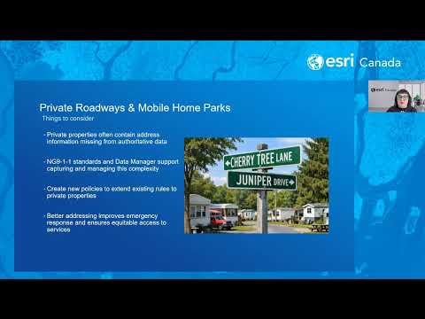
View OptionsJoin us for an in-depth look at managing complex address and private road information as part of your NG9-1-1 GIS data preparedness journey. In this webinar you will learn why this GIS data is so crit
Watch Video
Part eight. In this session, you'll learn the basics of the configurator application to customize the data manager application to your specific needs.
Watch Video
Want to get on the road to NG9-1-1?
Contact usPart 7. You'll learn how to create emergency services boundaries, review discrepancy reports to make any required data revisions, and make data submissions to NG9-1-1 data aggregators.
Watch Video
Part six of Esri Canada's NG9-1-1 Data Manager video series. You'll learn how to add an image, such as a subdivision plan, add a reference grid as a drawing guide, and using the road tie point service
Watch Video
Welcome to part 5 of Esri Canada's NG9-1-1 Data Manager instructional video series. In this session, we cover how to use the road editing tools.
Watch Video
Welcome to part four of Esri Canada's NG9-1-1 Data Manager instructional video series. In this session, you'll learn how to place units in 2D and 3D buildings.
Watch Video
Welcome to part three of Esri Canada's NG9-1-1 Data Manager instructional video series. In this session, you'll learn the process of placing addresses along a road using grid placement methods.
Watch Video
Part 2 of Esri Canada's NG9-1-1 Data Manager instructional videos. In this session, you'll learn the process of placing multiple addresses within parcels and buildings and placing address along roads.
Watch Video
Part 1 of Esri Canada's NG9-1-1 Data Manager instructional videos. In this session, you'll get an intro to the tools available for placing addresses and editing and managing road and boundary info
Watch Video
Upgrade to 2.4—streamlined NG9-1-1 workflows, submit to aggregators, review discrepancies fast.
View
Use summer student support to accelerate NG9-1-1 GIS readiness with address updates, field checks, data cleanup, and quality control.
View
Join our AMA-style webinar to engage with Esri Canada’s NG9-1-1 GIS experts. Get all your GIS questions answered, from specific data to general insights on transitioning to NG9-1-1 GIS. Address the ch
Watch Video
The Esri Canada Address Manager helps communities maintain NG9-1-1-compliant GIS data—civic addresses, street centrelines, and service boundaries. It ensures data quality at the source, reduces discre
Watch Video
Watch the webinar recording where we explore the Community Map of Canada – the definitive basemap built by Canadians for Canadians.
Watch Video
Welcome to the What’s New in Address Manager 2.3 Part 3 instructional video.
Watch Video
Welcome to the What’s New in Address Manager 2.3 Part 2 instructional video.
Watch Video
The A‑B‑Cs of C‑L‑D‑X‑F-CA: A FAQ for the newly published CLDXF‑CA Standard
View
Welcome to the What’s New in Address Manager 2.3 Part 1 instructional video.
Watch Video
Join us on Wednesday May 14 at 1:00pm ET for an engaging discussion as we explore the Community Map of Canada – the definitive basemap built by Canadians for Canadians.
Watch Video
Loading More...