Esri Canada achieves rare ISO 31700-1 Privacy by Design certification
ISO 31700-1 Privacy by Design certification reinforces Esri Canada’s commitment to proactive privacy protection and trusted cloud services.
View
ISO 31700-1 Privacy by Design certification reinforces Esri Canada’s commitment to proactive privacy protection and trusted cloud services.
View
Error - something went wrong!
Download the e-book
Thank you!
Learn how Esri’s Disaster Response Program helps organizations scale GIS support when emergency response capacity is exceeded
View
Transport Canada’s enterprise GIS connects field data to policy, driving secure, data driven decisions and redefining the federal model.
View
Learn how police services are using GIS to operationalize hotspot policing. This webinar highlights real-world examples from Ottawa and Barrie Police, showing how spatial and temporal crime analysis s
Watch Video
Watch Video
Looking for answers to your questions on emergency management?
Learn moreOperationalizing hotspot policing—from analysis to action—fusing models, methods and experience from Ottawa, Barrie, and London Police using ArcGIS.
View
Canada’s wildfire seasons are growing longer and more destructive, but for many communities, the real story begins long before the flames arrive, especially in the Wildland-Urban Interface (WUI), wher
Watch Video
Find out how location can help you uncover trends and build a safer community.
ExplorePart eight. In this session, you'll learn the basics of the configurator application to customize the data manager application to your specific needs.
Watch Video
Part 7. You'll learn how to create emergency services boundaries, review discrepancy reports to make any required data revisions, and make data submissions to NG9-1-1 data aggregators.
Watch Video
Part six of Esri Canada's NG9-1-1 Data Manager video series. You'll learn how to add an image, such as a subdivision plan, add a reference grid as a drawing guide, and using the road tie point service
Watch Video
Welcome to part 5 of Esri Canada's NG9-1-1 Data Manager instructional video series. In this session, we cover how to use the road editing tools.
Watch Video
Welcome to part four of Esri Canada's NG9-1-1 Data Manager instructional video series. In this session, you'll learn how to place units in 2D and 3D buildings.
Watch Video
How police agencies operationalize GIS for real-time visibility, compliance monitoring, and hotspot response. Watch the story and register for our hotspot policing session.
Watch Video
Want to learn more about how GIS is helping implement NG9-1-1?
View postsBuild safer school routes using spatial analysis and dynamic mapping in ArcGIS Online to uncover risk patterns and support data-driven action.
View
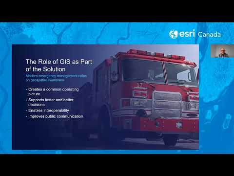
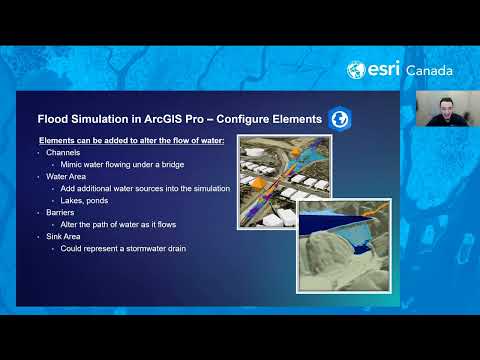
In this webinar, we’ll explore practical workflows for visualizing flood data and creating interactive maps that illustrate potential flood extents and impacts. You’ll learn how ArcGIS Solutions can a
Watch Video
Upgrade to 2.4—streamlined NG9-1-1 workflows, submit to aggregators, review discrepancies fast.
View
Enhance NG911 data quality with fast address point creation and smooth road renaming in NG911 Data Manager—built for accuracy, speed and reliability.
View
“Lead with location” playbook features 12 Canadian examples on how to boost field operations using geographic information systems.
View
Stay ahead of the forecast with the Weather Engine app, created by Huntsville and Lake of Bays using the Community Map of Canada for real-time local weather conditions. Weather Engine
Watch Video
Stay ahead of the forecast with the Weather Engine app, created by Huntsville and Lake of Bays using the Community Map of Canada for real-time local weather conditions. Margaret Stead
Watch Video
Loading More...