Esri Canada joins GeoIgnite 2026 as Bronze Sponsor
GIS leader supports GeoIgnite conference and the Canadian Geospatial Forum to help advance Canada’s geospatial future.
View
GIS leader supports GeoIgnite conference and the Canadian Geospatial Forum to help advance Canada’s geospatial future.
View
Curious about GIS for your Water Utility?
Request DemoParcelMap BC, developed and maintained by the Land Title and Survey Authority of BC, is the trusted land management system mapping more than two million parcels for use by governments, utilities and o
Watch Video
ArcGIS supports geography, history, science, math, and Indigenous education while building the skills students need today and in the future.
View
New offering streamlines management of Esri’s enterprise GIS platform, accelerating business value with secure, scalable Canadian cloud services.
View
Hey GeoSnappers! Is your ArcGIS Desktop maintenance about to expire or has it expired? This video covers how to update Creator user types and ArcGIS Pro add-on licenses that are expiring or expired a
Watch Video
Enhance your Cityworks experience with accurate, authoritative Canadian data by adding the Community Map of Canada as a basemap.
View
Want to take your ArcGIS web map to the next level? Try using Arcade, a simple programming language, to add nuance and functionality to your popups.
View
Canada’s wildfire seasons are growing longer and more destructive, but for many communities, the real story begins long before the flames arrive, especially in the Wildland-Urban Interface (WUI), wher
Watch Video
Exploring how spatial data empowers REACH Nexus, based at St. Michael’s Hospital, to expand HIV testing and harm-reduction services nationwide.
View
In this episode of Geographical Thinking, host Michelle Brake sits down with Darian Shakerinia from Fathom Studio to explore how GIS is shaping the next generation of community planning and design.
Watch Video
Discover how Fathom Studio blends GIS and AI to power better planning, improve decision‑making and shape the future of community design.
View
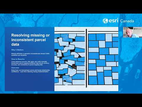
GIS managers can ensure a successful Computer Assisted Mass Appraisal (CAMA) migration by prioritizing deep data cleansing, establishing robust spatial validation and fostering cross-functional collab
Watch Video
Discover the latest updates to ArcGIS Hub, ArcGIS Living Atlas and ArcGIS for Microsoft. Stay ahead with new GIS tools and smarter workflows with this edition of Getting Technical.
View
A clear overview of what you need to know before upgrading an enterprise geodatabase, including versioning, client compatibility and planning considerations.
View
Follow this step-by-step guide to update and activate your Cityworks 15.8.x and Office Companion license to ensure your site runs without interruptions.
View
Microsoft Azure Maps replaces the soon-to-be deprecated Bing Maps. This blog post explains how to leverage Azure Maps in your web maps and ArcGIS Pro.
View
Discover how millimetre‑accurate field data cuts errors, reduces repeat locates and improves safety across PUC’s underground operations.
View
Stay in the loop with Software announcements in ArcGIS Pro! In this GeoSnap, we walk through how ArcGIS Pro keeps you informed about updates, new features and important changes right inside the applic
Watch Video
Canadian firm transforms work zone safety with AI and GIS, helping cities boost road safety, ease congestion and improve permit compliance.
View
Discover how educators Jennifer Morris and Hillary Weppler use ArcGIS StoryMaps to help students connect with WWI history in a meaningful way.
View
Loading More...