Underground insight: Transforming fieldwork with reliable asset data
Sault Ste. Marie’s PUC cut its accuracy gap by 99% from three metres down to 2.54 centimetres by modernizing how it maps underground assets. As part of PUC’s Strategic Plan commitment to GIS and innovation, crews can now capture field data once, retain it permanently and share it across teams. This precision helps water and electric utilities pinpoint buried infrastructure faster, reducing repeat locates, delays and safety risks. Here is how they did it.
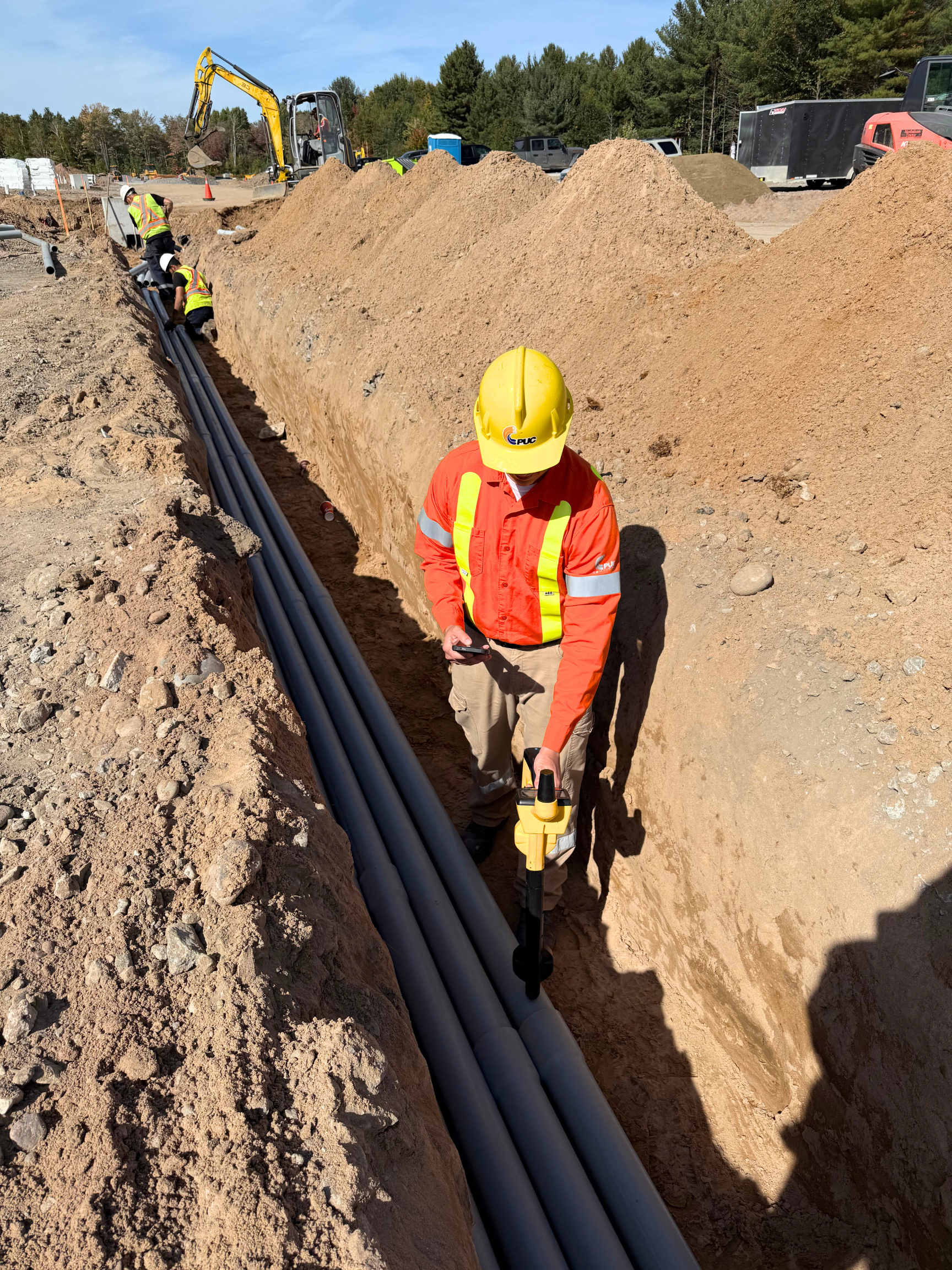
Millimetre-level accuracy: PUC locator maps underground pipe and cable locations with an upgraded locate device to prevent damage before and during excavation.
The challenge with underground records
Managing underground utilities is complex for any public utility, and Sault Ste. Marie PUC faced a particularly steep challenge. With installations dating back more than 100 years, record-keeping standards varied widely over the decades, some assets were logged carefully, while others existed only on paper maps.
This led to three persistent roadblocks:
-
- Difficulty retaining accurate locations of underground assets found by the locates department.
- Discrepancies between historical records and what crews discover in the field.
- No simple digital way for field crews to capture notes and context in real time.
Craig Martin, Manager of Geographic Information Systems at PUC, explains the limitations of their old system.
“We had top-of-the-line devices, but they weren’t enabled to link to our GIS. We could only get GPS accuracy within three to five metres, and that’s just not enough.”
Without the ability to connect their data directly to the GIS, PUC crews relied on hard copy hand-drawn records. This meant repeat trips, inconsistent data and no easy way to share findings across departments.
Building the solution
To modernize underground asset management, PUC combined equipment upgrades with a GIS-enabled workflow that streamlined data capture and analysis. Strengthening the accuracy and accessibility of this data aligns directly with PUC’s strategic direction to modernize GIS and improve operational efficiency.
Key steps included:
Millimetre-level accuracy receivers: Upgraded locate devices to be both Real Time Kinematic (RTK) and Bluetooth enabled, reducing error by more than 99% from 3–5 metres to about 2.54 centimetres.
Mobile connection to GIS: Deployed the TerraFlow Utility Mapper mobile app to connect receivers to ArcGIS Online, ensuring data flows directly from the field into their GIS system.
Field data enhancements: Configured ArcGIS Online schemas to support photos, attachments and a notes layer for field crews.
ArcGIS Dashboards for accountability: Built role-specific dashboards for locates crews, GIS editors and water and electric engineering teams, showing discrepancies, escalations and resolutions in real time.
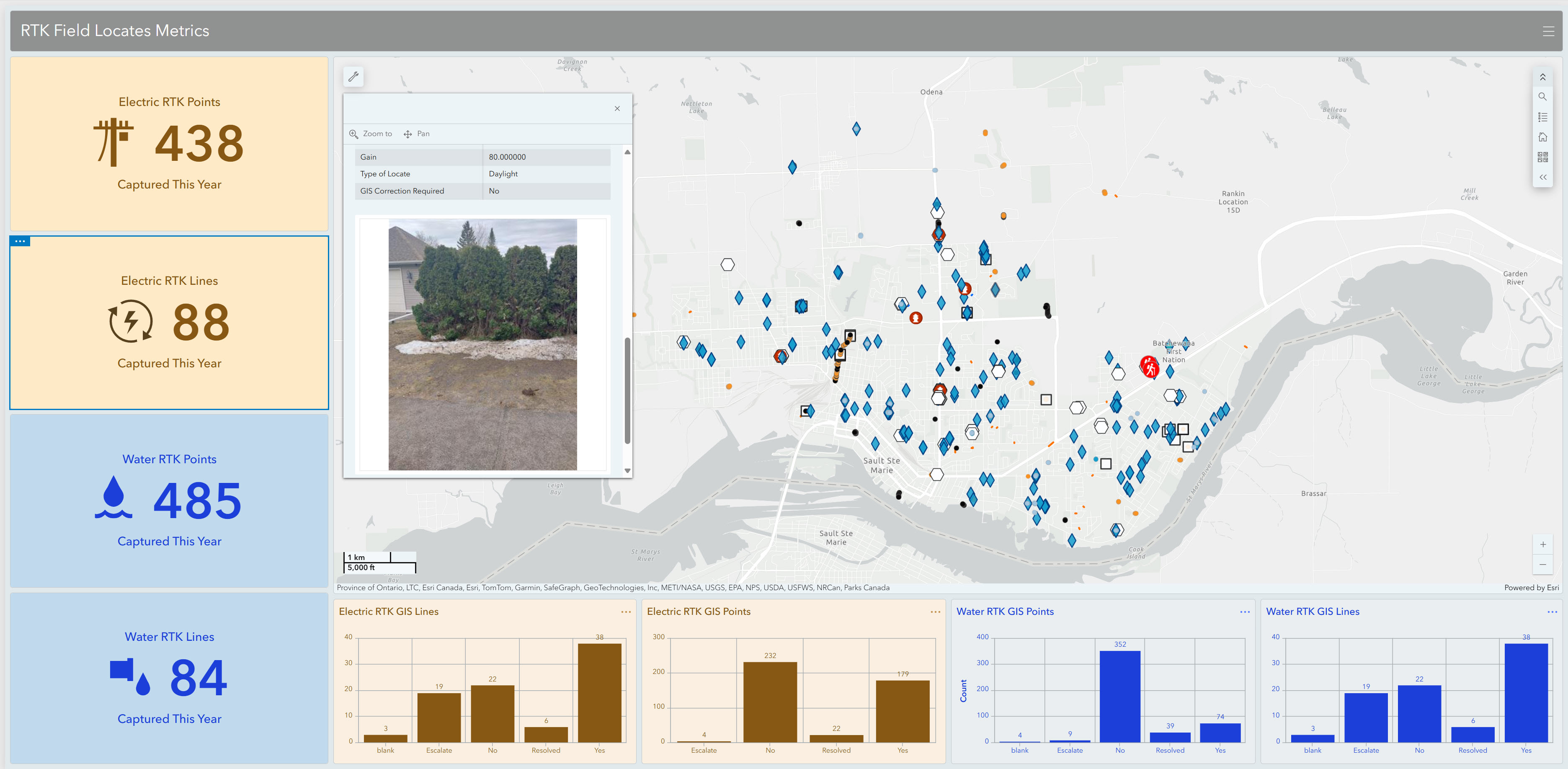
RTK Field Locates Metrics dashboard indicates RTK points and status for both electric and water utilities, along with photos of the sites measured.
From the field user’s perspective, the TerraFlow Utility Mapper app runs on a mobile device and connects to the RTK enabled receiver. A locator opens the app, selects the asset and records its position with millimetre-level accuracy. They can attach photos, notes or documents, and once saved, the data flows directly into ArcGIS Online as part of PUC’s permanent GIS record.
“The missing piece was enabling the mobile devices for GIS where the data could be retained and accessible to the rest of the corporation. Once we plugged in that last step, it took on a life of its own.”
- Craig Martin, Manager of Geographic Information Systems, PUC
Everyone benefits
With accurate data flowing seamlessly across departments, the impact of these improvements extends beyond the field, transforming how teams collaborate, make decisions and serve the community. Here are a few examples of this impact in action:
1. Greater accuracy and confidence
Crews now capture asset positions with millimetre-level precision, creating the most reliable underground records in PUC’s history.
2. Faster, smarter fieldwork
A new “walk back” feature guides staff back to assets without repeating the entire locates process. Combined with photo attachments and notes, crews spend less time re-finding and more time solving problems.
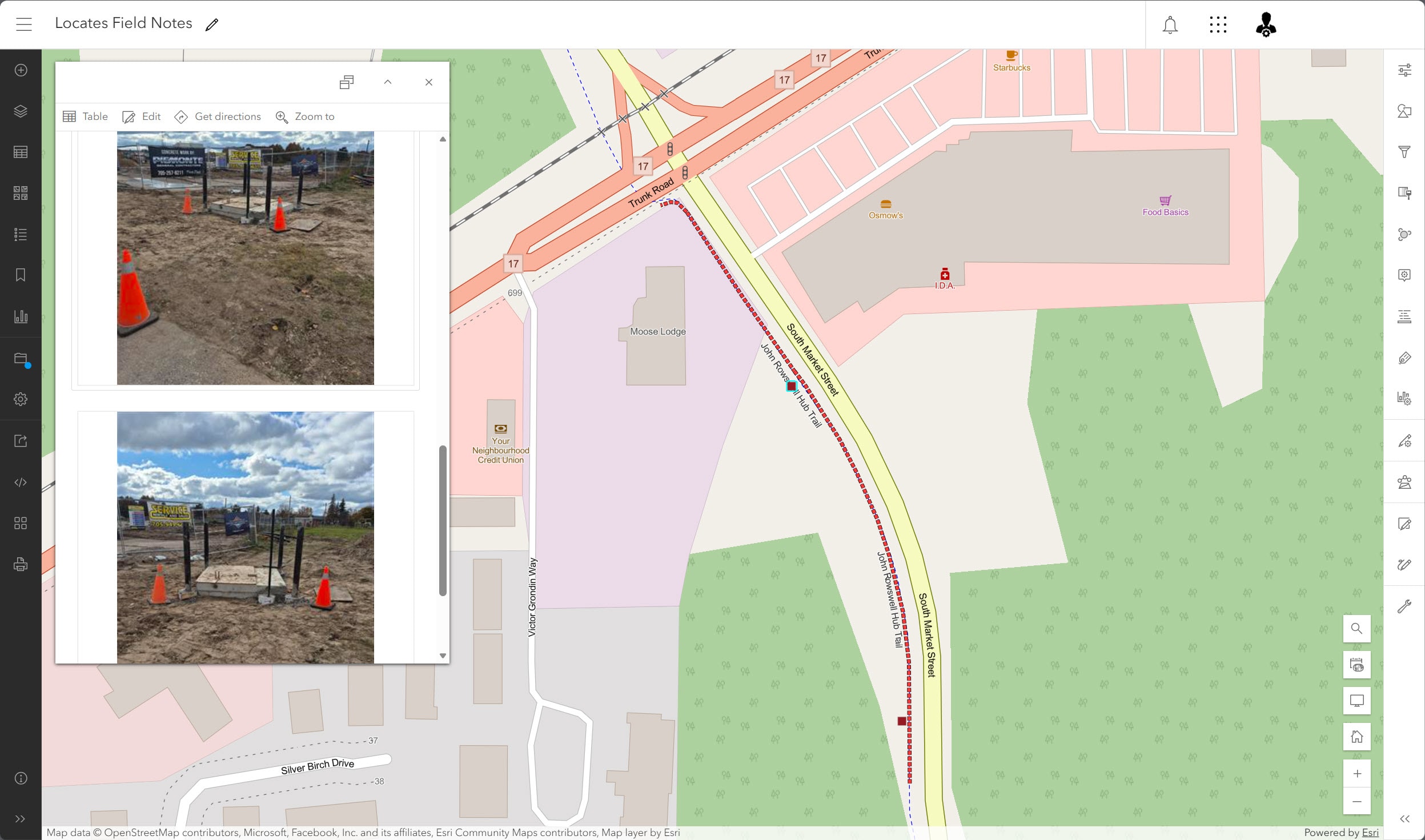
New Notes layer on map of worksite in ArcGIS Field Maps with photos and text.
3. Year-round clarity
Extreme winter weather once made it nearly impossible to visualize summer locates under deep snow. Now photos and digital notes provide critical context no matter the season.
4. Empowered staff
Locates teams are capturing and storing more than coordinates. They can upload photos, documents and scanned records. When they saw how attachments worked, they requested more features like a dedicated notes layer, which PUC quickly enabled in ArcGIS Field Maps.
5. Seamless collaboration
Dashboards connect multiple teams in real time. Locators capture and flag discrepancies; GIS editors quarterback corrections and engineering teams address escalations.
6. Breaking down silos
What once lived only in binders and hand-drawn sketches is now retained digitally, accessible across the organization and available for future analysis.
7. Community advantages
For SSM residents, these improvements mean safer, more reliable utility service. Crews respond faster, reduce service disruptions and plan maintenance more effectively, supporting a higher level of service for the community.
Results with lasting impact
The new system is now part of daily operations. Locates crews capture points within millimetres every time they enter the field. Dashboards track metrics and status, building a long-term organizational record.
The results are threefold:
- Growing data volume: Every RTK capture is logged, monitored and retained, steadily expanding PUC’s accurate underground dataset.
- Clear status tracking: Assets are flagged, corrected and resolved, creating a full life-cycle record. This shared visibility is already improving communication across departments and helping teams coordinate multi-department solutions, even in year one.
- Permanent digital records: All findings are now stored in the GIS rather than one-off drawings. PUC is already working with fewer unknowns and more consistent operations.
Most importantly, data is permanent, accessible and actionable. By combining historical records with verified RTK field data, PUC is building its most reliable underground map to date.
This shift has delivered:
-
- Higher accuracy for better decision making.
- Stronger collaboration between locator, GIS, field operations and engineering teams.
- Efficiency gains through real-time dashboards.
- Long-term records with photos and notes.
- Enhanced safety for workers and contractors through better awareness of underground assets.
As Martin reflected, the change is cultural as much as technical. Instead of being lost to filing cabinets, the data is now building a permanent digital record that will strengthen decision-making, collaboration and operational efficiency well into the future.
Future direction
PUC sees this as only the beginning. With a growing stream of verified data feeding into their GIS as a single, trusted source of truth, the utility can unlock new insights, expand collaboration and build resilience for decades to come.
As part of PUC’s Strategic Plan, investing in GIS innovation ensures we work safer and smarter, improving service reliability for Sault Ste. Marie customers.
Martin’s message to other utilities is simple: retain your data. What starts as a locate in the field should live on as part of a permanent digital system that benefits the entire organization.
Learn more
Esri Canada utilities: esri.ca/water | esri.ca/electric
PUC Services Inc.: puc.ca
Let’s hear your story!
Have you used GIS or a partner solution to solve a challenge or improve your organization? We would love to showcase your success and inspire others. Share your experience and contribute to industry knowledge with a GIS Success Story.