Esri Developer & Technology Summit: A Higher Education Perspective
This year’s Developer & Technology Summit, the 20th anniversary of the conference, had a large focus on artificial intelligence across the ArcGIS platform. Several new developments were presented that have great potential for use in education and research, including upcoming AI assistants to help with creating maps on the web and in ArcGIS Pro.
This March I attended Esri’s Developer & Technology Summit, formerly known as the Developer Summit or Dev Summit. Although my focus and area of interest is 3D advancements in the ArcGIS platform, the plenary and sessions offered a range of topics for developers and non-developers at every level. In this blog post, I will outline general highlights from the main plenary and include links to video recordings of the sessions for those who couldn’t be there in person or want to watch it again.
The Day 1 Plenary began with an engaging three minute video recap of the last twenty years at the Developer Summit, showing how the dev summit has grown from an attendance of 400 to now a couple thousand attendees. The video captures how the ArcGIS platform has expanded over the years from ArcGIS desktop to now include web GIS, mobile app development and ArcGIS Pro.
The first two demos presented tools for working with data. ArcGIS Data Pipelines was the first demo, which is an ArcGIS Online product released last year that can import data from local and cloud sources, perform operations on the data, and output to a chosen format (My colleague Kendra recently wrote about testing its capabilities). Next, a Geospatial AI foundation model built for satellite imagery called Privthi was demoed. The model can perform burn scar mapping, flood mapping, or crop classification. The first part of the plenary concluded with a demo of the Zurich digital twin, showing how the ArcGIS and Autodesk platforms can be integrated using ArcGIS GeoBIM.
AI was the first topic covered after the break, with an ArcGIS Pro demo showing how a pretrained vision language model could assess building damage from the Los Angeles wildfires earlier this year. If you would like to learn more about GeoAI, our higher education resource finder includes a tutorial using pre-trained models from the Living Atlas. A productivity tool called the Arcade Assistant, which will be available in beta in June, was demonstrated next. The interface provides a chat box to help with the creation of arcade expressions. This tool will help users enhance their web maps using Arcade expressions for pop-ups, labels, and symbols.
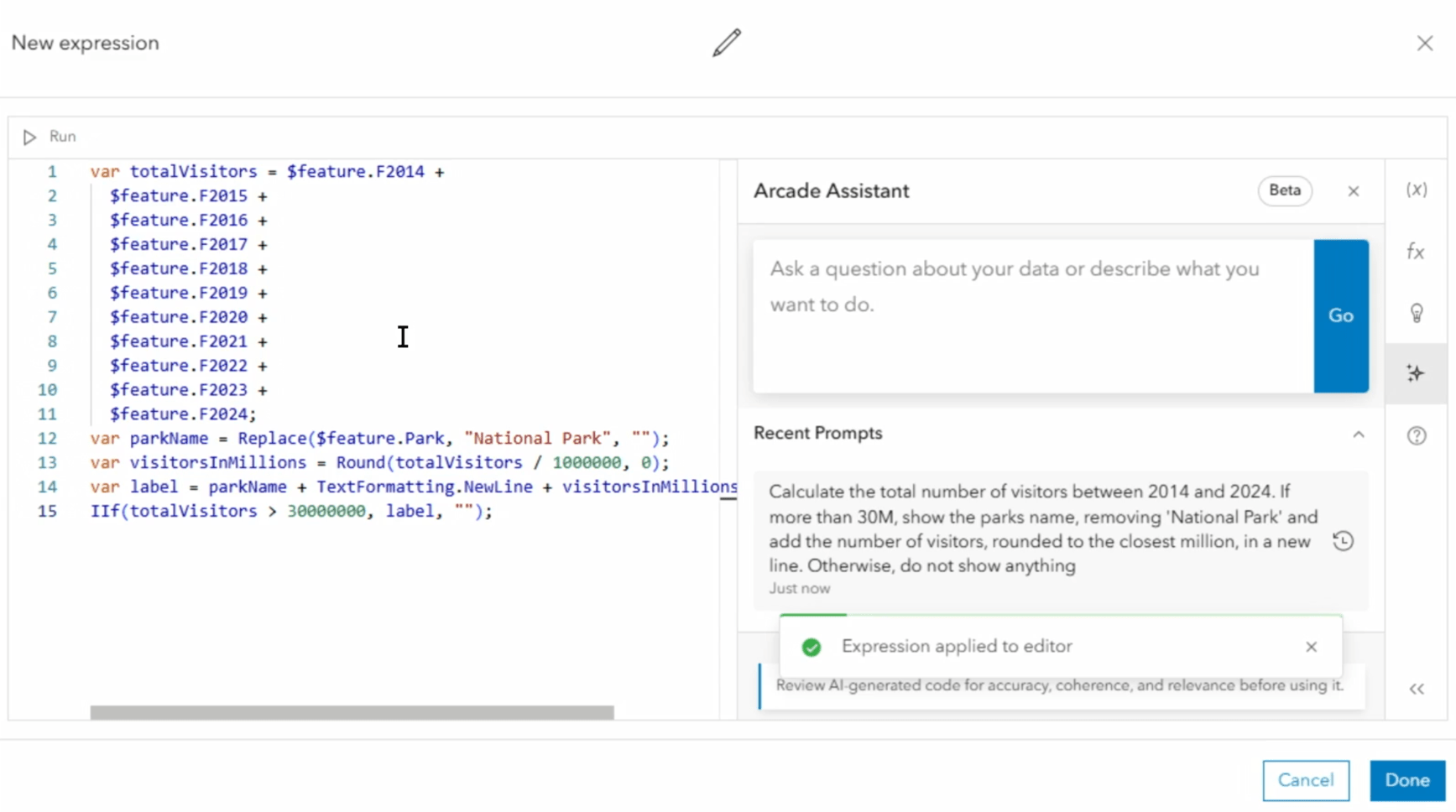
Demonstration of the Arcade Assistant
The Day 2 Plenary began with a focus on building apps, including using ArcGIS Instant Apps, automating changes to ArcGIS Dashboards with Python, and creating apps with ArcGIS Experience Builder. Next, ArcGIS Pro customization was covered with the introduction of a new Visual Studio Code Debugger Extension -- that received much applause from the audience. This debugger lets the developer set breakpoints and explore the execution of custom Python tools in ArcGIS Pro. Extending ArcGIS Pro was discussed using Add-ins, managed configurations, plug-in data sources for custom input data, and creating a headless version of ArcGIS Pro for automation with the ArcGIS.CoreHost assembly. This extensibility of ArcGIS Pro can be very useful for GIS research projects, as demonstrated by the recent Esri Young Scholar winner’s custom ArcGIS Pro add-in for geographic automata.
The ArcGIS Pro AI Assistant was introduced next. This will become available in beta with ArcGIS Pro 3.5 and allow the user to use natural language to explore documentation, generate queries, and run geoprocessing tools to accomplish a task. Natural language descriptions of custom functions can also be provided by developers so that this functionality can be invoked by the assistant. These AI assistants will undoubtedly have a growing influence on how GIS users learn to use the tools and approach problem solving moving forward.
At the end of the morning session, an AI mapping application that lets users ask questions about the links in a supply chain was demonstrated. This demo used an upcoming feature called the AI Skills Framework, which is outlined in the architectural diagram below. It will be interesting to see how this technology evolves as AI advancements continue at a rapid pace.
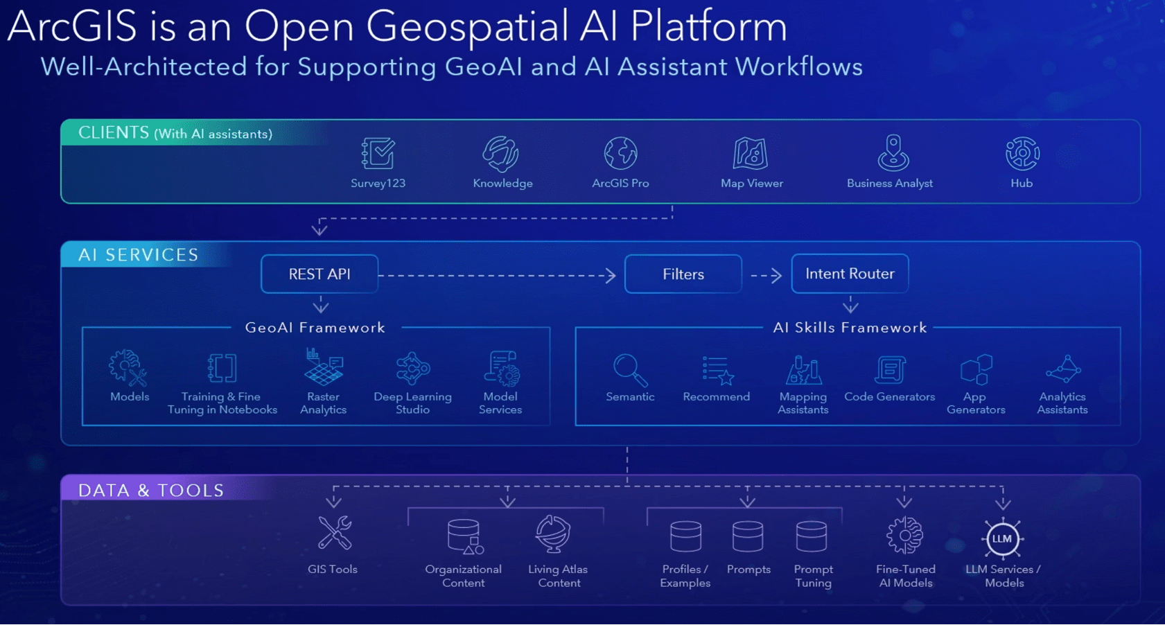
Architecture diagram of AI across the ArcGIS platform
The ArcGIS SDK for game engines was presented, showing enhancements to the next release of the software such as elevation exaggeration and 3D tile support. Native app development was shown next, followed by a demo of new web components available in the ArcGIS Maps SDK for JavaScript.
Day 3 began with a keynote presentation showing how Baron Weather, a U.S. company that offers real-time data and forecasts, hosts and makes their weather data available. The next keynote discussed how NATO uses GIS web technologies and ArcGIS Enterprise to create geospatial products, applications, services, and analytics. The final keynote was from the Port of Corpus Christi in Texas showing a demo of how they used the ArcGIS Maps SDK for Unity to create a digital twin of the port for situational awareness.
The conference included many in-depth presentations detailing the advancements presented at the plenary and also featured an expo with Esri staff available to answer questions about the ArcGIS products. I spent a lot of time at the expo hall as it was a great opportunity to learn more about the software capabilities and get specific advice for GIS projects I am working on. There were many more ArcGIS products and features shown in the plenary beyond what I’ve highlighted. You can explore these in the video recordings available here.