Year in Review: Conferences Attended by the Higher Education Team in 2025
As part of the larger Education & Research Group, the Higher Education team aims to promote and support GIS learning across higher education institutions in Canada. There are so many new methods, technological advancements, and industry applications to keep apprised of in the ever-growing field of GIS that continuous learning is required to stay ahead of the curve, and we try to attend conferences when we can. Here’s a look at some of the events we attended in 2025, as well as our key highlights and takeaways!

This year the Higher Education group attended nine conferences around North America.
Spring
Esri Developer & Technology Summit
There was a lot to learn at the Dev Summit this year! Sessions covered a variety of topics on the latest in Esri technology, including new capabilities in ArcGIS Field Apps and Maps SDKs for Game Engines.
While most of us did not attend in person, our Lead Developer Michael did! You can read about his impressions of the Dev Summit here.
One of Jonathan’s (our resident UI/UX expert) favourite sessions was Eyes on Design: The Art and Science of Creating Intuitive Interfaces – which was not actually focused on Esri’s app builders or Calcite design system, but rather on the cognitive aspects of visual design that need to be considered in order to achieve a well-designed app.
ASTM Committee Week
Jonathan is an active member of a task group that has published a Standard Guide on Climate and Community Mapping for the ASTM, helping users choose between various online environmental mapping tools and providing guidance on considerations around data quality. He attended the first of two ASTM Committee Weeks, held annually.
On the first day he sat in on several committee meetings, learning about different standard documents being deployed including for flood remediation technologies and climate terminology. On the second day he and Malena McCrossan from our Living Atlas team co-led a training session with Dr. Cynthia Annett (Kansas State University) on their standard guide, with a hands-on mapping activity utilizing data in the ArcGIS Living Atlas of the World.
Canadian Association of Geographers (CAG) 2025 Annual Conference
Alex attended the CAG Conference where he presented on different types of AI and AI tools in the ArcGIS system. He also shared some of the GeoAI projects he and others in the group have been working on, including initiatives to extract missing road features in Canada from satellite imagery using deep learning, and improve customer experience assessment by using LLMs to help evaluate event feedback and derive a sentiment score.
There were several interesting and diverse talks that stood out to Alex, including a presentation on historical maps and data that have influenced Canadian boundary disputes, and one examining how geography impacted historical battles and events near Fort Beauséjour. The cartographic keynote from Martin Gamache was particularly memorable with excellent guidelines, emphasizing how projections, typography, and the details can really change your view of the entire map.
Upper Bound 2025
Our Lead Data Scientist Mohamed attended Upper Bound, an annual event that aims to foster discussions on the current state and future potential of AI. Mohamed attended several thought-provoking talks, including ones from Richard Sutton (Amii) who shared foundational insights on AI advancement; John Carmack (Keen Technologies), who explored engineering perspectives in AI; and Kory Mathewson (Google DeepMind), who discussed creative AI applications.

Key takeaways for Mohamed were the announcement of a new Google-Amii initiative to advance AI research and education across Canadian post-secondary institutions, and more generally the emphasis on the need for building AI literacy and fluency to prepare students for the future job market, which strongly aligns with our team values at Esri Canada. Discussions are currently underway to explore collaboration with Amii to further enhance AI education and innovation.
Summer
Carto 2025
Krista kicked off the summer at Carto 2025, the annual conference of the Association of Canadian Map Libraries and Archive - Association des cartothèques et archives cartographiques du Canada (ACMLA-ACACC). Their members face the interesting crossover of managing both physical maps and digital resources. She was only able to attend the last day, which began with an insightful panel discussion on the challenges librarians have faced over the years in migrating collections between VMs or servers, and additional issues around preserving digital content that the average GIS user doesn’t normally have to think about.
Another standout was an engaging presentation from instructor Rob Harrap on his experiences teaching a course that mixed creative fantasy world-building with real-world cartographic tools. Students were tasked with collaboratively building an evolving fantasy world, and following civilizations as they emerged, developed, and disappeared.
She also joined a tour of the archiving and document preservation lab at Queens University – a highlight of the event!
Esri User Conference
As always, the UC offered a glimpse into the novel and interesting work being done by GIS users worldwide, as well as informative demos on best practices and workflows delivered by Esri staff. This year, several sessions caught our attention:
- The Plenary – with a moving reminder from Jack that small, individual contributions are still significant in bringing about change
- ArcGIS Online: Best Practices for Content Management and Item Discoverability – recognition of concerns shared by many organizations about managing ever-growing content, with general strategies for data governance policies, communication, and administration practices
- ArcGIS: Data Exploration and Visualization for Spatial Analysis – insights on different methods such as chart and graph types for effective data visualization
- And of course, the ever-popular Map Wizardry session, with Kenneth Field, John Nelson, and Nathan Shephard diving into fun examples of cartographic magic!
Fall
Esri Canada Federal GIS Conference
Mohamed presented during the plenary session at the Esri Canada Federal GIS Conference, introducing the different AI models and tools available in ArcGIS. While there, he learned about some of the great tools being developed for conservation and emergency management in Canada.
One notable example was Whale Insight, a bilingual GIS platform from the DFO that aggregates visual and acoustic observations of the critically endangered North Atlantic right whale to foster collaboration and support decision-making. Another was the Government Operation Centre’s Wildfire Dashboard, an emergency management tool developed using several ArcGIS applications to support real-time decision-making during wildfire events.
GIS in Education and Research Conference
Needless to say, we all attended our very own biennial GIS in Education and Research Conference. We were busy leading discussions, demos, and hands-on workshops, but we also had a chance to moderate or sit in on different paper sessions from educators and student researchers from across the country. It was inspiring to see all the fantastic work being done at Canadian universities, across themes as diverse as public health, spatial ecology, urban and transportation planning, and GeoAI.
In one such presentation Jacob Klimczak (student, University of Toronto), who has worked closely with David from our Higher Ed team, demonstrated the innovative use of machine learning models to optimize potential urban block layouts based on zoning requirements and stakeholder preferences. The model results are passed into ArcGIS Pro and CityEngine, where a custom rule generates realistic build-out visualizations.
Esri Canada User Conference
We were excited to attend the Esri Canada User Conference in Toronto this year, the first Canadian UC since 2019. With over 1400 users and staff in attendance, it was a great opportunity to connect face-to-face, and to learn from other experts in the company and professional world regarding the latest in geospatial technology and real-world applications.
Our team was heavily involved, presenting sessions on GeoAI and integrated 3D planning and visualization workflows, and plenary talks, on top of manning the Education, 3D GIS, and Geospatial AI booths.
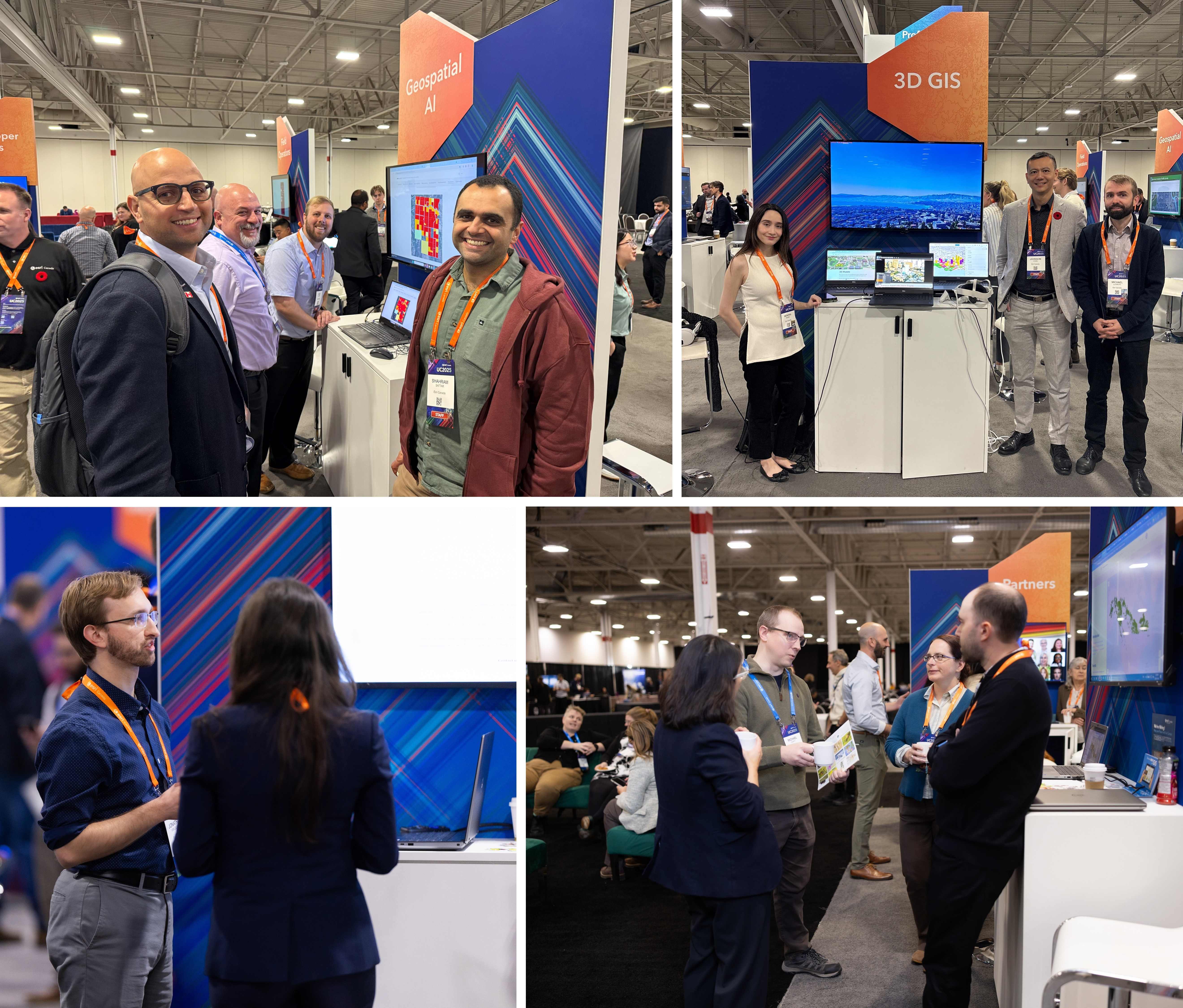
The Higher Education group at the Esri Canada UC! (Top-left, clockwise): Mohamed, Alex and Shahram, and Patrick DeLuca (GIS Specialist Lecturer Instructional Assistant, McMaster University) at the Geospatial AI kiosk (credit: Jean Tong); Kendra and Michael, and Johnson Chan (Senior Technical Solutions Specialist) at the 3D GIS kiosk; Krista and David, and Angela (K-12 Education Specialist) and former Higher Ed colleague Mike Leahy at the Education kiosk; and Jonathan at the Education kiosk.
And that’s a wrap on 2025! We look forward to meeting more of our colleagues in Canadian education at events in 2026. See you next year!