Smarter Together: Planners and GIS Analysts Need Each Other More Than Ever
No matter where you sit, collaboration between municipal planners and GIS professionals is where real community impact happens. By combining vision with data, and policy with spatial analysis, we can build more informed, sustainable, and responsive communities.
In communities across Canada, municipal planners are navigating enormous challenges, from housing shortages to climate resilience to growing communities, often without enough time, tools, or data. But what if there was a way to make long-term planning faster, clearer, and more collaborative?
That’s exactly what GIS can do.
Most planners are aware of GIS, but many aren’t tapping into its full potential.
Over the past couple of years, I’ve been speaking with municipal planners from across Canada and so many have either taken a course on GIS in school or have used it briefly or access planning data through it. But I think municipal planners could be taking advantage of more GIS to make their jobs easier.
Let’s take a step back and de-mystify “GIS”, or geographic information systems. GIS connects data to a map, integrating location data (where things are) with all types of descriptive information (what things are like there). This helps users understand patterns, relationships, and geographic context.
I’m not saying I think every planner should be a GIS expert. I’m suggesting that planners should understand what GIS is capable of and what it can help them achieve. Because a lot of the pain points that I hear about from municipal planners, especially those in long-term planning, can be solved with GIS solutions.
So what can GIS do for you?
This blog is going to focus on how municipal planners and GIS analysts can work together in ArcGIS Urban. Urban is a web-based 3D planning tool, which offers a collaborative environment where planners, GIS analysts, and decision-makers can work together. You can visualize scenarios, test zoning changes, evaluate development impacts, and engage the public through data-driven storytelling.

With ArcGIS Urban, planners can simulate zoning changes, estimate potential housing unit increases, and evaluate impacts
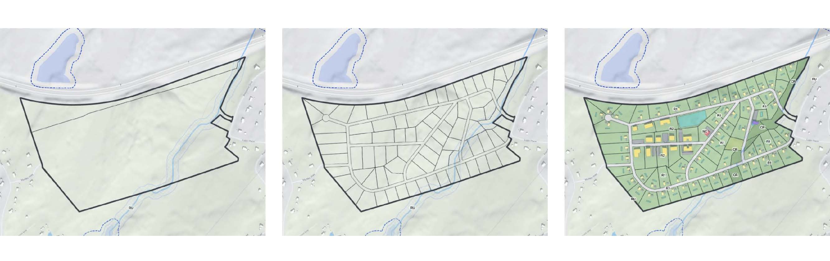
First, we’ll explore how planners can use ArcGIS Urban to tackle one of their biggest challenges: capacity planning. In a mid-sized city updating its planning policies, questions arise like: Where can we build more housing? What infrastructure will that require? What are the trade-offs?
With ArcGIS Urban, planners can simulate zoning changes, estimate potential housing unit increases, and evaluate impacts on infrastructure, green space, and tax revenue—all through intuitive 3D visuals and customizable metrics.
Urban even includes a parcel suitability tool, which helps planners determine where to place new schools, community centres, or mixed-use zones based on real constraints and opportunities. Best of all, multiple team members can collaborate on scenarios in real time.
GIS can also streamline development application reviews. Typically, data lives in separate systems, departments work in silos, and context gets lost in the shuffle.
With ArcGIS Urban, all parties from developers to legal teams to city council, can view a single, centralized planning system. Developers can submit their 2D and 3D site plans, which municipal planners can upload to Urban. They can then overlay zoning and transportation data and review how proposed developments align with broader community goals.
As projects evolve, different design phases can be added, and progress tracked. This transparency not only speeds up review times but helps planners align short-term approvals with long-term housing and growth targets.

Developers can submit 3D site plans which municipal planners can upload to ArcGIS Urban
One of the most powerful applications of ArcGIS Urban is in climate change mitigation. Planners are increasingly being asked to reduce car dependency, mitigate flood risk, and cool down heat islands, while still accommodating growth.
Using ArcGIS Urban, municipal planners can:
- Visualize flood risk zones and test mitigation strategies like green infrastructure or redistributing density.
- Identify neighborhoods vulnerable to extreme heat and model interventions such as green roofs or community gardens.
- Reduce care dependency by evaluating how new developments might impact transportation patterns and explore options like transit-oriented development or expanded bike lanes.
- Compare long-term costs and savings of implementation and maintenance of different adaptation measures through scenarios and identify the most suitable option.
By visualizing and measuring the real impact of different strategies, planners can make more informed decisions and clearly communicate those decisions to residents and stakeholders.
Despite the name, ArcGIS Urban is not just for large cities. Rural and less populous areas can benefit just as much, especially as growth pressures expand beyond urban cores.
For example, rural planners can use the ArcGIS Urban to:
- Simulate growth scenarios based on viable lots and land constraints (like septic field requirements or farmland protections).
- Forecast water and sewer demand, assess infrastructure needs, and plan proactively for new housing.
- Preserve the rural character of communities while planning for sustainable, thoughtful growth.
No Mountain of Data Required
One of the most common concerns planners have is: Where do I even start?
The answer is that you don’t need a huge data library or advanced technical skills. ArcGIS Urban can be launched with just a few basic inputs like zoning layers and parcel data, plus a few assumptions. You can start with a single neighbourhood, build one scenario, and grow from there.
And with Esri Canada’s professional services team assisting you, even municipalities with limited internal resources can get up and running quickly. Our team can help with data preparation, tool deployment, scenario setup, and training, ensuring your team is ready to collaborate and plan with confidence.
Bringing Everyone to the Table
ArcGIS Urban is not just a planning tool. It’s a platform that brings GIS analysts, planners, engineers, and residents together.
By working in a shared digital environment, everyone benefits from a single source of truth, where updates are reflected in real time and planning conversations are grounded in data, visuals, and shared goals.
We’re not trying to turn planners into GIS pros. We’re trying to help planners and GIS teams work better together so we can build communities that are resilient, connected, and ready to grow.
If you’re interested in learning more about how municipal planners and GIS analysts can work together using ArcGIS Urban, and support their community’s growth needs, register for our upcoming webinar.
Whether you’re a GIS analyst looking to collaborate more closely with your planning department, or a planner curious about the power of spatial tools, one thing is clear: digital planning tools are no longer a luxury, they’re a necessity.