Laying the groundwork for a successful GIS program
If you want to increase the use of geographic information systems (GIS) as a strategic resource within your organization, there’s no better place to start than to build the visibility of your GIS program. But where’s the best place to get started? In this blog post, Esri Canada management consultant Alexandre Guy identifies three pillars to success that you can use as a place to start: an empowered GIS governance program, an informed leadership and intentional communication.
Nowadays, with GIS being intertwined with so many of an organization’s projects, laying the groundwork for GIS success can feel daunting. When you think about it, the success of your GIS program underpins the success of your organization in many ways. As a GIS leader, you know that your GIS function is more than a contributor, it’s an enabler of organizational performance. But it may not be seen that way by top-level decision makers. So how do you make them see it that way? How do you make your GIS group be seen and heard at the right levels to allow for better decisions and better outcomes?
In a nutshell, you need strong governance, empowered leadership and intentional communication.
Let’s dive in and talk about each one of these requirements.
Governing for success
Being able to make timely decisions is one of the core competencies of management. But it’s tough, as there are different angles to account for, diverging opinions, a constant lack of information and unexpected events that make us second-guess our thought process. Moreover, how do the decisions you make relate to other in-flight initiatives?
In our management consulting practice, we encounter this problem in many of our engagements. In many cases, one way or another, the organization we’re assisting has been lacking proper formal decision-making processes, leading to misalignment with the rest of the organization. This misalignment in decision-making inadvertently leads to confusion as to what the priorities are amongst stakeholders. On many occasions, it leads to frustration. People will either take responsibility for their own destiny, or they’ll blame the GIS group for its inability to respond to business needs.
The way to address this issue is by implementing a formal decision-making body, a strong governance, that will structure the decision-making process. As an example, a municipality might set up a GIS governance board that reviews project proposals monthly to ensure alignment with strategic goals. The board would have the authority to determine whether to invest resources in a given project.
At its core, governance is responsible for directing and managing GIS operations and activities. Its focus is on implementing a structured approach to decision-making and, more importantly, maintaining the organization’s overall strategic direction. That is, it ensures that all decisions related to GIS are fully aligned with the organization’s goals and objectives.
But more than that, it sets the organization up for success by defining clear roles and responsibilities across the board, enforcing procedures and policies, and monitoring performance and project outcomes. An example of this is implementation of a data stewardship committee under the GIS governance board that oversees the proper application and enforcement of all GIS data policies. In doing so, the committee ensures consistency throughout the organization, raising the quality of the geospatial data that gets produced.
The result is that GIS, through its governance body, provides value to the business because its operations are properly monitored, and because each output follows a strict set of policies and standards that ensure quality.
Once that’s set, you need to make your GIS shine.
Empowering leadership
Leadership is not a title; it’s a role that everyone in the organization plays. Often, employees will wait for leadership to act, to make the necessary decisions. It doesn't have to be this way; you can foster leadership by appropriately communicating key messages at different levels throughout your organization for better overall success.
For starters, you need to be intentional in your approach by setting up strategic communication goals to make your GIS program shine. Examples of this include:
- leveraging GIS to offer strategic insights to organizational leaders
- positioning GIS as an essential decision support function
- resolving key technical issues through collaboration
- building internal capacity through continuous training
A typical GIS program would have 5–6 goals destined for different stakeholders.
Talking about stakeholders, it’s a good idea to define who your stakeholders are and derive specific messages directed at each stakeholder group. A typical set of messages might look like this:
- Strategic level: “The GIS function is a pillar upon which a broad range of services relies. Our processes enable multiple activities including operations, project evaluation, communication and workforce promotion.”
- Tactical level: “As a hub of technical experts within the organization, our mission is to deliver value by seeking consensus on tactical issues and promote engagement amongst ourselves in different forums.”
- Operational level: “Our organization relies heavily on GIS to make informed decisions. Accurate information is key.”
Once you’ve properly defined your messages, it’s time to derive specific communication channels for every stakeholder group as represented in the chart below.
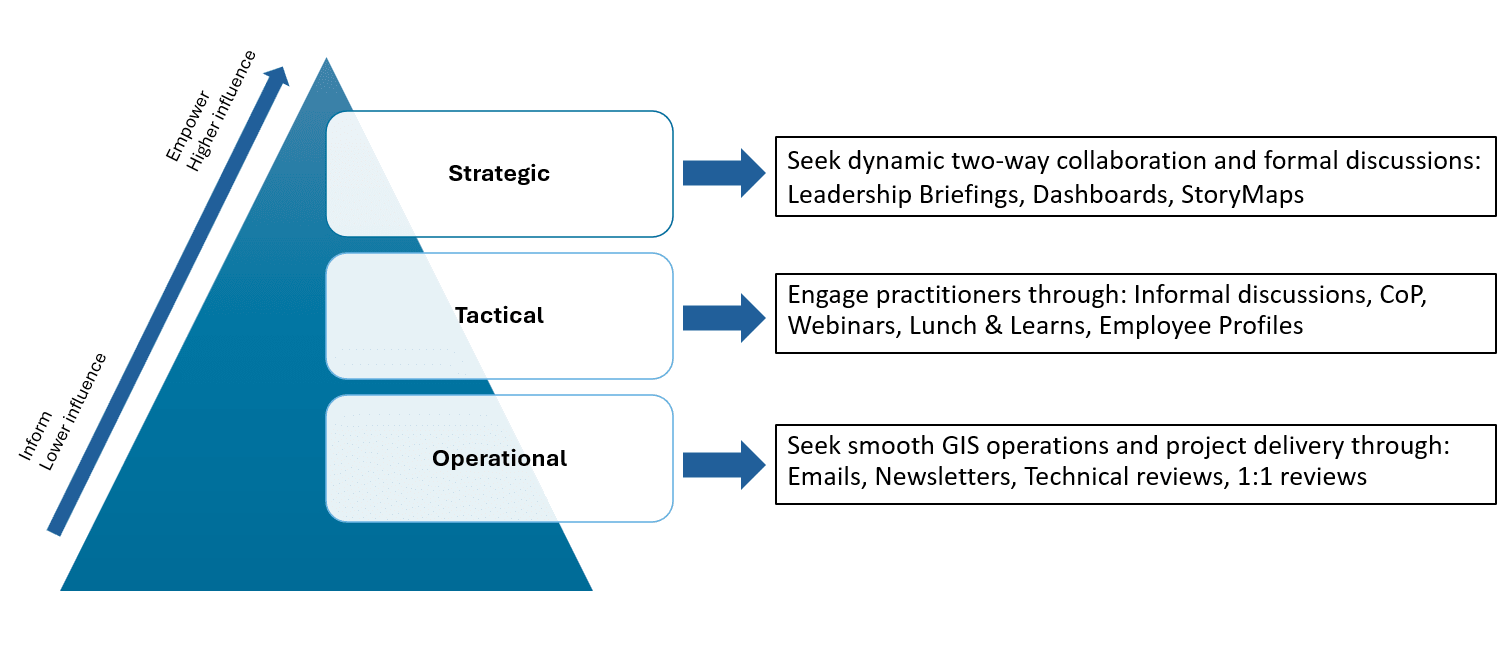
As shown in the diagram above, you can engage stakeholders at different levels through different channels. At the operational level, information is being shared broadly through newsletters and technical reviews, whereas at the tactical working level, the idea is to foster collaboration through Communities of Practice and lunch & learns. Conversely, at the strategic level, communication is targeted at a small group of influential leaders to empower decision-makers with briefings and decision support dashboards with all relevant information concisely summarized.
You’ll notice that leadership engagement is promoted at all levels of the organization using different tools. This ensures that you’re not only engaging “leaders” at the top of the organization, but that you’re also setting the right tone whether at the employee, the working group or the overarching strategic level. Only by keeping all your stakeholders informed, engaged and aligned with your goals can you promote value to higher levels of the organization.
You now have a shining, decision-making GIS program. It’s time to bring it all together by building empowerment.
From information to influence
When we’re talking about empowerment, what we really mean is that you want to enable your organization to make better decisions with GIS. And what this really is, is influence. It’s moving from being an information-sharing organization to becoming a partner in fulfilling your organization’s mission.
It’s about being able to deliver the right message at the right level. The goal is to move from producing geospatial information that gets shared broadly on your company intranet, to being consulted to create leadership briefings, to generating location intelligence and, finally, to becoming a strong partner in fulfilling your organization’s mission and goals.
In other words, GIS must evolve from reporting data to shaping decisions through actionable insights.
And what better way to do this than using the tool we’re experts in: GIS!
By delivering high-quality data, summarized as dashboards and leadership briefings, your GIS function will make gains in notoriety, influence and trust. That trust will grow over time as your team becomes the go-to group for strategic awareness and location intelligence. Only then will the GIS function’s influence be strong enough for it to be thought of as a strategic enabler, a function truly capable of increasing your overall organizational performance. A true partner.
Once we tie everything together, this is how it looks:
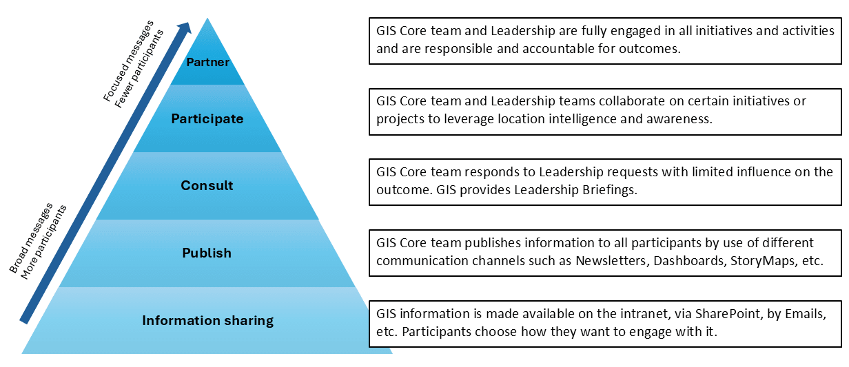
The message changes and becomes more targeted as we climb the pyramid. The top tier is where the most value is obtained. There, the GIS program is creating location intelligence and is fully responsible and accountable for project outcomes. This is only possible if the bottom tiers are running smoothly and have the necessary standards in place to ensure high-quality data is generated.
In the end, what you have is a well-performing GIS program where timely decisions are made and leadership engagement is promoted at all levels with targeted messaging and intentional communication.
All this sets the base for increased influence over time, allowing you to climb the influence pyramid and evolve your GIS program from an information-generating machine to a strategic partner engaged in the success of your organization.
In conclusion
By taking the long view and laying the groundwork through governance, leadership engagement and communication, GIS program leaders set themselves for success by gaining in influence and emerging as true partners to their organizations’ success.
As organizations increasingly rely on data-driven insights to drive decisions, having a mature GIS program is becoming more and more central to future success. By strengthening the three pillars I’ve set out in this blog post, you’ll be well on your way.
Want to add more geospatial strategy tips to your toolbox? Sign up for our newsletter, The Geospatial Edge, to get a fresh batch of geospatial strategy resources delivered right to your inbox once per quarter. Simply visit our Preference Centre and select “GIS Strategy” from the available options.
This post was written in French by Alexandre Guy and can be viewed here.