Empowering Vancouver Police: How GIS Modernized Patrol Operations
In the heart of Vancouver, a quiet revolution is transforming how police officers keep the city safe. The Vancouver Police Department (VPD) has taken a bold step towards modernizing their patrol operations, ensuring officers on the front lines have access to real-time intelligence—right when they need it most.
Challenge: Bridging the Gap Between Command and Front-Line Response
VPD recognized the need for a new approach to modern policing. While their Operations Command Centre (OCC) was equipped with data-rich dashboards, the challenge lay in bridging the information gap between the OCC and officers on the street. Front-line officers needed real-time, actionable data that could help them respond quickly without being bogged down by overwhelming amounts of information.
At the same time, command staff needed tools that could help coordinate resources across the city, ensuring efficient and timely responses to incidents.
“Officers would get these static printouts at the start of each shift, but by the time they were out on the streets, it was difficult to remember which house had been broken into,” explains Dr. Ryan Prox, O.O.M., Officer in Charge of the Crime Analytics Advisory & Development Unit (CAADU) at Vancouver Police Department. “We needed a system that could help us track incidents in real time.”
Solution: Real-Time Situational Awareness for Safer Communities
To tackle these challenges, VPD turned to a familiar yet powerful tool—GeoDASH. Developed with support from Esri Canada and VertiGIS, GeoDASH leverages advanced GIS (Geographic Information System) technology to provide real-time situational awareness for both officers in the field and command staff. Initially designed for analysts to visualize crime trends, GeoDASH evolved into a critical tool that could deliver up-to-the-second data directly to those who need it most—VPD’s front-line officers.
This wasn’t just about adding another tool to the mix. The focus was on making data meaningful and immediately actionable:
- User-Centred Design: The adapted GeoDASH system offers a streamlined interface, allowing officers to view crime incidents, forecasts, and CAD (Computer-Aided Dispatch) data in real-time.
“As a Constable in the Property Crime Unit, I use GeoDASH daily to track reported Break and Enters and compare these incidents to known offenders that frequent these areas. By matching incident MO in areas with emerging clusters and offender MO, I can identify persons of interest for investigative follow up,” said an anonymous source within the organization.
- Operations Awareness Mode: This feature uses GPS to centre the map on the officer’s vehicle, highlighting incidents within a 300-metre radius, helping officers stay focused on their immediate environment.
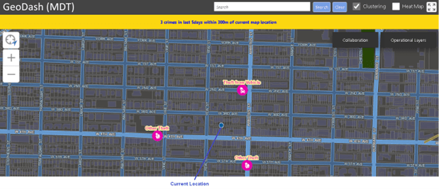
Officer Awareness Mode
- Enhanced Situational Awareness: Officers can access summaries of incidents with just a tap, seeing nearby calls and other patrol units in real-time, all while staying in the same system—no more toggling between screens.
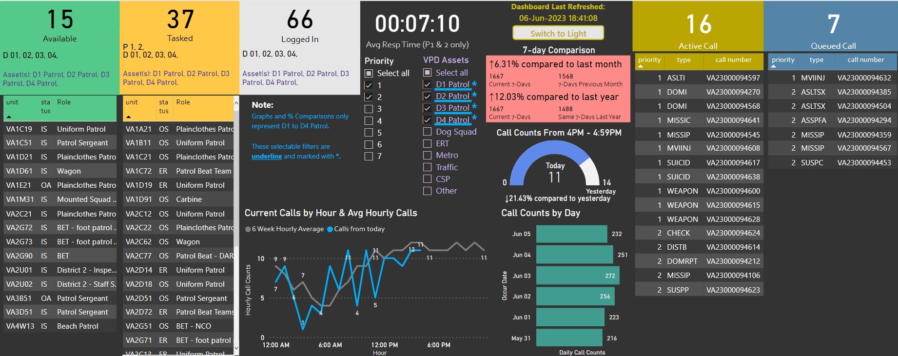 GeoDASH interface
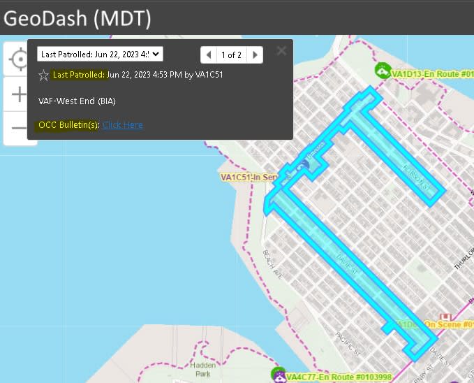
Priority patrol zones in Vancouver
“I find GeoDASH to be easy to use. Everything is intuitively set up and has a similar look and feel to familiar Windows products.” Sgt Lorna Berndsen, Patrol.
Results: Real-Time Impact, Real-World Change
The implementation of GeoDASH delivered significant, measurable improvements to VPD’s patrol operations:
- Quicker Decision-Making: With essential information at their fingertips, the public has experienced a significant reduction in response times within the city centre, where in the past, entry to high-rise buildings posed a challenge. Officers can now connect with resources that can facilitate entry into secure buildings within moments of arriving at an emergency call.
- Proactive Policing: The introduction of the Priority Patrol Zones (PPZ) feature helped officers focus efforts in areas experiencing spikes in crime, like clusters of thefts or break-ins, ensuring timely interventions.
![]()
Priority Patrol Zones Summary
- Stronger Coordination: The OCC, armed with real-time data, could better allocate resources and provide tactical support during critical incidents, creating a seamless connection between the command centre and the streets.
- Faster Resolutions for Missing Persons Cases: GeoDASH has been a game changer in handling missing persons cases, especially for vulnerable individuals, such as youth at risk and the elderly. The ability to quickly share information and photos through the system has resulted in rapid discovery – sometimes within hours.
- Enhanced Officer Safety: The ability to see the locations of nearby officers and request immediate backup has improved officer safety in high-risk situations, such as dealing with known gang members or conducting bail condition checks.
![]()
Gang Crime Tracking
“As a Sergeant responsible for supervising a Patrol team, I use GeoDASH to determine the best areas to deploy my units where they can have the greatest impact in reducing crime.” Sgt Lorna Berndsen, Patrol.
Conclusion: A Modern Tool for Modern Policing
The Vancouver Police Department’s adoption of GeoDASH, developed with core technology from Esri Canada and VertiGIS, has transformed how officers patrol the streets. Powered by Esri’s ArcGIS Portal Server and VertiGIS Studio, the system enables seamless, real-time data sharing between command staff and officers in the field.
The result? A safer, more resilient community and a police department equipped to meet the demands of modern urban policing.
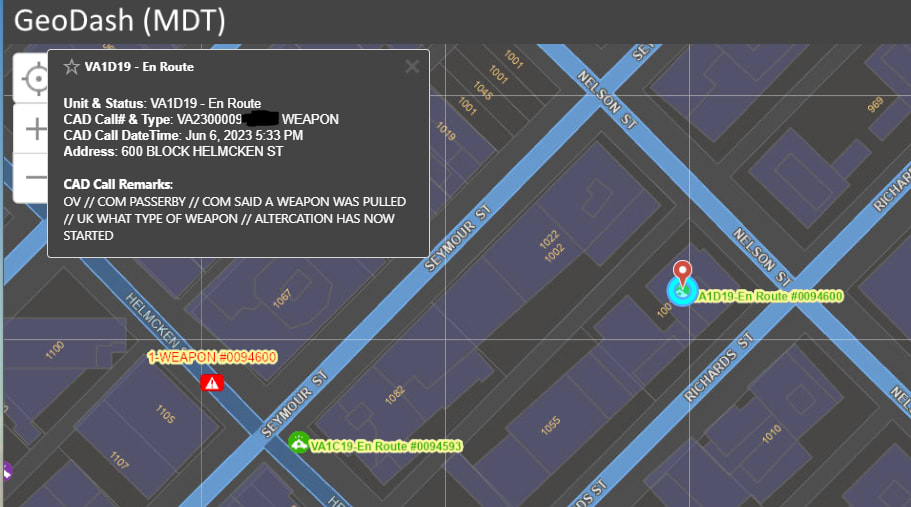
Cover Units
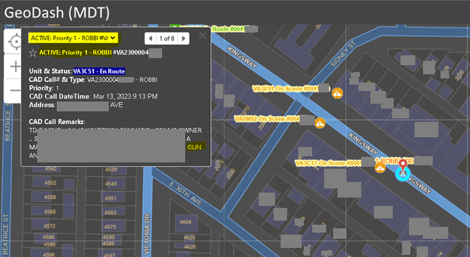
Priority 1 Robbery
Discover how GIS technology is transforming public safety across Canada. Explore Esri Canada's comprehensive solutions designed to support law enforcement agencies in enhancing operational efficiency and community safety: click here.