Adding the Offline Community Basemap of Canada to Field Maps Designer
Don't let offline limitations hold you back—unlock the full potential of your fieldwork with the Offline Community Basemap of Canada in Field Maps Designer. This integration ensures you have the most accurate and up-to-date Canadian basemap at your fingertips, even in areas with limited connectivity.
Community Map of Canada Vector Basemaps
Esri Canada has been facilitating the production of an accurate and up-to-date topographic national web basemap, incorporating data contributions from authoritative Canadian communities. If you’re interested in contributing your data, learn more about our Community Map Program.
The Community Map of Canada vector basemaps are available in Map Viewer and Scene Viewer, as well as in ArcGIS Pro and configurable apps with a basemap gallery feature, such as ArcGIS Field Maps, Workforce for ArcGIS and Survey123.
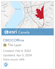
The Community Map Program has also worked to develop a tile layer of the Topographic style of the Community Map of Canada that has been enabled to be downloaded and used in an offline map, the CMOCOffline tile layer.
The updates for the CMOCOffline tile layer are collected each day and an updated version of the map is published once a month.
Note: This Community Map of Canada vector basemap does not contain the Hillshade layer.
Adding the Offline Tile Layer to a Web Map
Before you can use Field Maps Designer to create maps for an offline environment, you will need to set up a web map with the CMOCOffline tile layer. The following series of steps can be performed in either ArcGIS Online or ArcGIS Enterprise, as the CMOCOffline tile layer is part of the Living Atlas.
- Open Your Web Map:
- Sign into your ArcGIS Online or ArcGIS Enterprise account.
- Open the New Web Map viewer.
- Access Basemap Options:
- Select the Basemap button and click the arrow next to the defaulted Topographic Map basemap.
- Click Add to bring up Add Layer window.
- Select the arrow next to Content and choose Living Atlas.
- Search for the CMOCOffline tile layer from Esri Canada by searching CMOC and select Add to add the layer to the Web Map.
- Remove the Default Basemaps:
- Click on the current basemap thumbnail or the basemap dropdown arrow.
- This action will open a list of available basemaps.
- Find the default basemap you want to remove from the list.
- Click the three dots to expand the options and select Remove.
- Save your Changes:
- Once you've made your changes, preview the map to ensure it appears as expected without the default basemap.
- Click the Save button on the right-hand side of the Web Map Viewer.
- Share the Web Map:
- In the Web Map Viewer, locate and click on the Share button, located on the right-hand side.
By following these steps, you should be able to add the Community Map of Canada to a Web Map Viewer.
Note: Different versions of ArcGIS Enterprise may have variations on these steps.
The same steps are depicted below:

Enable Content to be Offline Ready
Before you can take the map offline, the layers and tables in the map must be enabled for offline use. The offline status of each layer and table is listed in the Content section and will present an error message if it:
- Is not enabled for sync
- Is a duplicate
- Contains an unsupported field type
- Contains a field name longer than 31 characters
- Is a tile layer not enabled for export tiles
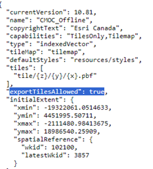
The CMOCOffline tile layer’s REST endpoint has 'exportTilesAllowed' set to true. This can be a little easier to miss since it’s not on an item details page. The CMOCOffline tile layer is already enabled for exportTiles, which you can view in the Service’s REST endpoint.
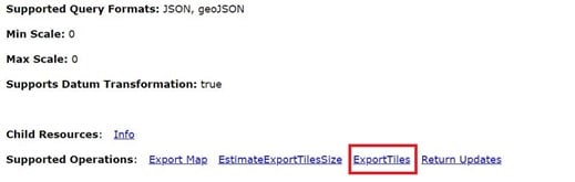
If you created your own basemap and it’s enabled, you should see an exportTiles operation at the REST endpoint of the service:
The exportTiles operation can be enabled in a service by ArcGIS Pro or the ArcGIS Server Administrator Directory. See here for more information.
For more information about offline data requirements, see Enabling layers and maps for offline use.
Configure the Map to Work Offline in Field Maps Designer
Ensure that mobile workers can take web maps offline if they will be working in areas without a reliable internet connection.
To create an offline map area using Field Maps Designer, complete the following steps:
- Open your Map from the main Field Maps Designer page.
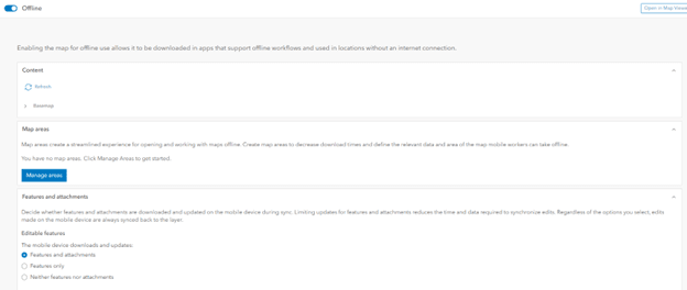
- Navigate to the Offline page, click the Map areas section to expand it, and click Manage areas.
- The Manage areas window appears.
- From here, you can create offline map areas for mobile workers the same way you create map areas in ArcGIS Online or ArcGIS Enterprise.
For step-by-step instructions, see:
- Take web maps offline in ArcGIS Online
- Take web maps offline in ArcGIS Enterprise
- Work offline with Field Maps.
You Can Use the Offline Basemap in the Following Applications
You can use the offline basemap in even more Esri Applications beyond the Field Maps Designer including: