City of Kingston takes simple, systematic approach to ArcMap retirement
In this blog post from Esri Canada Advantage Program practice manager Julie Roebotham, discover the triage method the City of Kingston’s GIS team used to simplify their migration from ArcMap to ArcGIS Pro.
One of the best parts of being an advisor and working with clients through the Advantage Program is seeing all their different workflows and the different solutions they develop to tackle their challenges.
Anyone who’s been using ArcMap knows it’s been retired, and most organizations have been making plans to migrate to ArcGIS Pro. I remember when ArcGIS Pro first came out—there was a lot of consternation about using this new desktop platform. Change is hard, and when you’ve been using ArcMap forever, and have everything working exactly the way you want, moving to a new platform can be daunting.
As time has gone by, though, and especially as organizations start to use Web GIS, the feelings about ArcGIS Pro have changed. Some students coming out of schools have never even used ArcMap, and for those who have been using ArcGIS Pro for a while, ArcMap now feels like an unfamiliar acquaintance.
Still, there are some folks hanging onto ArcMap. Some of them have good reasons. Those migrating away from the geometric network still need to use ArcMap until a new network management method is adopted, but for most organizations moving to Pro, it’s more about being unsure of where to start. They may not be sure of the best way to approach the move, how to prioritize, what workflows they’ll need and when the best time would be to do it. In short, the migration process can be overwhelming.
With this in mind, when I saw how the City of Kingston planned and prioritized their own move from ArcMap to ArcGIS Pro, I was pretty excited. Every time I bring it up, in fact, they laugh at me because for them, it seemed like a simple plan. For me, however, who has seen other organizations approach the Pro migration in myriad ways, it was the sheer simplicity of their process that stuck out to me.
And so, with their blessing and without further ado, I present to you Kingston’s approach for prioritizing Pro migrations—probably the most simple, yet most effective plan I have seen so far.
Compile the data
The City has a tool that gives them details about what is installed on their users’ machines. Their GIS team was able to generate a report that identified who at the City of Kingston actually had ArcMap installed. This report also provided details on machine name and assigned user, last machine login time, what version of ArcMap is installed, the number of days since ArcMap was used and whether the user already had ArcGIS Pro installed.
This information alone is a gem—if someone has ArcMap but hasn’t used it in 365 days, then that in itself gives you some idea of how critical it is to this user.
In order to further identify this user, they worked with their HR system to classify which department and position this user was in. Doing this allowed the GIS team to categorize users by department, which simplified the planning and any communication that needed to go to these teams.
Lastly, they augmented the report with information either coming from their enterprise geodatabase, via an assessment of their end users, and/or based on the team’s own knowledge of departmental workflows. This information included things like their role in the enterprise geodatabase, whether they used Attribute Assistant or the Geometric Network, whether they had any integration requirements and how dependent they were on ArcMap (a rating from 0–5).Compiling this report gives a ton of insight on who the City’s ArcMap users are, what their dependencies on ArcMap might be and any migration considerations related to recreating their workflows. Kingston not only wanted to plan the move from ArcMap to ArcGIS Pro, but also wanted to identify whether any of the uses would be better served by a web-based workflow. Taking a look at all this data in one place allowed them to understand who their users are and what each individual migration would require.
Categorize and prioritize
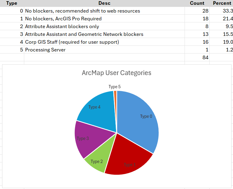
The Kingston GIS team then turned their attention to categorizing the types of blockers that might be stopping these folks from migrating. In the end they came up with six potential categories of blockers:
0: No blockers, recommended shift to web resources
1: No blockers, ArcGIS Pro required
2: Attribute Assistant blockers only
3: Attribute Assistant and Geometric Network blockers
4: Corporate GIS staff (required to support users)
5: Processing server
You might wonder what the Attribute Assistant blocker is, and this is an interesting one. Attribute Assistant was an add-in tool in ArcMap that allowed for automatic calculations to occur during editing. The ArcGIS Pro migration pathway for this is Attribute Rules, but these are rules applied to the database instead of an interface add-in. Once you apply an attribute rule to a feature class, you can no longer open it directly in ArcMap. This means the team had to come up with a holistic approach—basically compiling information on who was using feature classes in ArcMap that would eventually come to have Attribute Rules. For most users, this meant migrating them all at the same time from using Attribute Assistant to Attribute Rules. For the few users who needed to stay in ArcMap for Geometric Network reasons, but needed to view feature classes with an attribute rule configured, a workaround was discovered where these users could pull in the data from the feature class with the attribute rule to ArcMap through a read-only feature service.
There were a few considerations like this, but ultimately at the end of this exercise, Kingston was left with a prioritization framework for migrating users that looked like this:
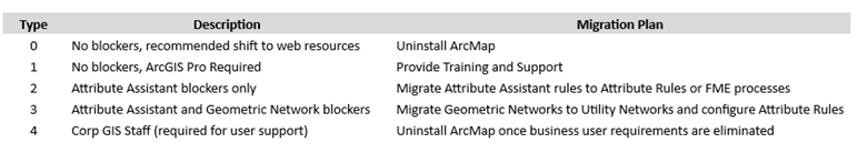
Once the blockers were understood, a high-level migration plan was created for each user-based type of blocker:
Enact according to plan
And with that, the City had their plan to proceed. They started with the Type 0 blockers and are systematically making their way through all the blockers possible (minus the Geometric Network blockers). Currently they have completed levels 0 and 1 and have plans for migrating their attribute assistant users to attribute rules as part of a larger data migration plan.
When they started, there were 126 installations of ArcMap originally identified by this tool. At this point in time, they are down to 26, which includes the corporate GIS staff who need to keep ArcMap for support reasons, and which make up half of that number.
I love seeing the simplicity of this approach. The tool Kingston uses that helps with the initial report is part of the magic, but it just goes to show that being a little systematic, starting with compiling all the data and allowing it to drive your decisions can make the looming change of ArcMap retirement a lot less work.
If you have ambitious plans for your organization’s GIS function but need help implementing them, Esri Canada’s Advantage Program is right for you. Or, if you’re interested in a 360 evaluation of your organization’s current geospatial maturity that provides rapid time-to-value, consider our Location Intelligence 360 service.