Prevent errors, reduce rework: GIS as a tool for AEC project collaboration
Often, when multidisciplinary architecture, engineering and construction (AEC) teams work on projects together, different capabilities can end up working in isolation from one another. That can lead to issues with communication and timeliness, which can in turn lead to costly rework and delays. In late 2024, Esri Canada’s Brad Ashley and Tiffany Chisholm joined forces with WSP’s Matthew Maloney to discuss how to create seamless data sharing and workflows using powerful GIS technology. This blog post summarizes a few of the key takeaways from that presentation so you can refer to them any time.
Collaboration in AEC: the foundation
Excellent collaboration is essential in any industry. So why is it especially important in architecture, engineering and construction (AEC)?
First, by improving collaboration, teams can enhance their efficiency on projects, which can lead to streamlined workflows, reduced rework and faster problem resolution. On large AEC projects that require careful management of limited budgets, these kinds of process improvements can lead to huge gains for any team, including early delivery, cost savings and improved relationships with clients.
Second, improvements in collaboration can improve design and innovation in turn, by allowing for better integration of different specialties into design, problem-solving and the end product. By getting different specialties on board at all stages of a project, potential issues that might arise because of a clash between specialties can instead be worked around. And by identifying potential issues before they can even occur, the team can again minimize costly rework and delays.
Third, AEC teams that prioritize collaboration can enhance their projects’ quality and better ensure compliance. Collaborative teams are more likely to catch quality issues, meet industry standards and avoid non-compliance—a win for teams and their clients alike.
Finally, collaboration strengthens relationships between team and client, increases client satisfaction and keeps stakeholders engaged and aligned with project progress.
What collaboration looks like between AEC teams using ArcGIS
AEC project collaboration within ArcGIS can take many different forms. The kind of collaboration you use will be a matter of what each partner in the collaboration is bringing to the table.
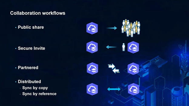
Within ArcGIS, collaboration in AEC can flow in many different ways, including:
- Public sharing: As an AEC team you have the capability to share information directly to the public, providing you have the permission to do so. This might include information about project status or road closures, for example. If you’re sharing using ArcGIS Online, you can use Online’s built-in sharing tools; if you’re in ArcGIS Enterprise, you can still share data publicly, but consider the external traffic into your internal system that this will create and be sure to monitor any performance effects.
- Secure invite: You can invite an individual collaborator (such as a client, partner or consultant) into your own environment if they already have an ArcGIS account, as long as you have their username.
- Partnered collaboration: Where two or more collaborators have ArcGIS Online and require two-way collaboration, you have the option of setting up a formal connection between your ArcGIS Online organizations. Collaboration coordinators can be set up within ArcGIS to help manage workflows and accounts and keep the project moving forward. Data shared between the groups can be used by both groups, allowing anyone within the partnership to develop new maps or apps as needed.
- Distributed collaboration: Distributed collaboration allows different ArcGIS systems to share data, ensuring that teams can work together efficiently, regardless of the specific software they’re using. This is similar to partnered collaboration, except that each organization’s ArcGIS entities remain separate and data is synced between them. Distributed collaboration allows for data sharing between ArcGIS Online and ArcGIS Enterprise as well as between two ArcGIS Enterprise systems, so it isn’t just used by two organizations working together—it can also be used within a single organization (e.g. if data is stored using ArcGIS Enterprise, then turned into externally shareable data products with ArcGIS Online).
Case study: How WSP is using ArcGIS for project collaboration
Matthew Moloney, team lead of Spatial Information Management within WSP Canada’s Ontario – Atlantic Earth and Environment business line, spoke about how WSP is leveraging Esri technology to enhance project collaboration.
WSP is one of the world's leading professional services firms, has been ranked #1 in ENR Magazine’s 2023 List of Top 225 International Design Firms, is a global leader in environmental services and is one of the fastest-growing firms in the AEC industry.
With over 6,500 ArcGIS users globally—over 1,850 of those in Canada—WSP is using ArcGIS for a number of collaboration functions. As an example, Matthew spoke about a transmission line project that WSP teamed with other organizations on. In support of this 350-km linear infrastructure project, WSP undertook a multi-criteria analysis for choosing the transmission line’s route, the Environmental Assessment, the Archaeological Assessment, the aggregate study and the post-EA Species at Risk studies; they also developed a commitments tracking system. Through that, WSP collaborated with their client, the client’s main engineering firm, the constructor and 14 Indigenous communities who were stakeholders on the project. Regulators also received project data.
To facilitate collaboration, WSP’s team hosted content in both ArcGIS Enterprise and ArcGIS Online, using a combination of distributed collaboration and stored credentials where necessary. The project included over 500 content items housed in ArcGIS, including feature layers, tile layers, map image layers, web maps, ArcGIS Experience Builder applications, ArcGIS Dashboards applications, surveys built in ArcGIS Survey123 and an ArcGIS Hub site. Needing to share such a large amount of data products made a robust collaboration structure essential for this highly complex team and project.
WSP collaborated with a number of organizations and subcontractors for field planning, publishing this information in their Web GIS environment powered by ArcGIS; they performed gap analysis in consultation with Indigenous communities and notified them of field locations by shared web applications. They also used GIS to plan which resources—for example, Indigenous field monitors—would need to be onsite and where. Tracking field data also enabled real-time visibility—enabled through web mapping applications and dashboards—for the project team and client on project progress. ArcGIS also enabled WSP to visualize versions of updated designs.
For more about how WSP used ArcGIS to enhance project collaboration, watch Matthew’s segment in the Optimizing AEC Project Collaboration webinar.
Digital collaboration tools powered by location
As the AEC industry continues to evolve, embracing collaboration through tools like Esri's ArcGIS can significantly enhance project outcomes, whether by allowing teams to increase interdisciplinary cohesion, or by creating central hubs where all members of a project team can find the information they need. By prioritizing collaboration, AEC firms can not only save time and avoid costly rework, but also foster innovation and enhance client relationships.
As a final note, check out these resources that Brad shared at the end of the webinar:
- GIS for Construction story: Get inspiration for how Esri technology can be used around a construction site.
- Training
Got questions? Reach out to Esri Canada’s Brad Ashley at bashley@esri.ca. Or, for more detail on any topic covered above, watch the full webinar.