Get more from your investment in geo with a GIS workforce assessment: pt. 1
GIS tools and data management maturity will only get you so far. To leverage organization-wide location intelligence, your workforce needs to be structured, managed and trained. The GIS workforce assessment process that Esri Canada management consultant Darren Sutton describes in this blog post will help you organize your GIS workforce to maximize value delivery.
Key takeaways
- To get the most out of your geographic information system (GIS) workforce as a strategic asset, Esri Canada management consultant Darren Sutton recommends running a GIS workforce assessment.
- Start by evaluating the existing scope of GIS in your organization: take a survey of GIS capabilities and uses, then organize that information using the nine GIS patterns of use so that you can see patterns more clearly.
- Review the GIS datasets your organization is using by polling or interviewing staff.
- Assess how GIS resources and reporting lines currently operate in your organization.
- Do a gap analysis, evaluating the organizational context, roles, processes, and skills and capabilities. What does your organization need, and what’s missing?
- Understand the roles that are currently represented among your workforce and what their responsibilities are.
Assessing your GIS workforce
Organizations of all sizes use geographic information system (GIS) technologies to obtain the benefits of location intelligence. But to maximize benefits, it’s not enough to acquire GIS software, manage data or bring a few specialists on board. A GIS program requires a diverse group of staff ranging from occasional users to subject matter experts, administrators, data stewards and supervisors. Taken together, we’re talking about a distinct subset of the workforce: a GIS workforce.
To maximize the value delivered by your GIS workforce, I recommend you do a focused assessment. There are several key reasons for this:
- GIS is a strategic enabler requiring data management, architectural planning, role definition and process planning. This unique combination of needs means that you need a focused approach to organizing staff and resources.
- GIS is really all about capabilities that extend across organizational units including planning, engineering, field services, sales, risk management and construction, to name a handful. Coordinating capabilities across multiple units requires a distinct focus.
- GIS skillsets themselves can be divided into several sub-categories, which I’ll describe in part 2 of this article series. This means that organizations can’t take a one-size-fits-all approach to developing GIS skillsets. You need to evaluate specific role-based needs and plan accordingly.
This is a complex topic with a lot to it, so I’ll be discussing the basics of how to run your own GIS workforce assessment across two posts. This is part 1, with part 2 coming soon.
Evaluating your current workforce
To do a GIS workforce assessment for your organization, you first need to know where you are starting. Begin by evaluating the scope of GIS in your organization. Most organizations have teams that support and manage GIS software, but also have committed groups of users from a range of different departments. Your scope will therefore be necessarily broad.
A good first step is to take a survey of GIS capabilities and uses in your organization. Ask what GIS tools are in use, what the most important spatial datasets are and how GIS capabilities support your organization’s goals. This will result in some unstructured information that may not make cohesive sense at first, but that’s fine. There are useful frameworks that can help put structure around your organization’s GIS use.
One such framework is the nine GIS patterns of use:
- Mapping and visualization: Understand locations and relationships with maps and visual representations
- Data management: Collect, organize and maintain accurate locations and details about assets and resources
- Field mobility: Manage and enable a mobile workforce to collect and access information in the field
- Monitoring: Track, manage and monitor assets and resources in real-time
- Analytics: Discover, quantify and predict trends and patterns to improve outcomes
- Design and planning: Evaluate alternative solutions and create optimal designs
- Decision support: Gain situational awareness and enable information-driven decision making
- Stakeholder engagement: Communicate and collaborate with citizens and external communities of interest
- Sharing and collaboration: Empower everyone to easily discover, use, make and share geographic information
Each pattern is broad on purpose, but taken together, these patterns of use are meant to help you map out how you’re using GIS. Compare the information you’ve gathered with these nine patterns. What patterns of use stand out? Which ones are widely used? Don’t ignore patterns of use that involve a small number of staff because these may be delivering critical (and easily overlooked) outcomes. List the most relevant patterns of use with respect to your workforce. Include examples of use, such as the kinds of maps staff reference most often or key processes that are supported by GIS in the field.
You should also review the GIS datasets your organization is using. You can poll or interview staff to find out what GIS datasets they rely on. Don’t forget that some of your colleagues probably create GIS data that other staff use. Think of your field-based staff; foresters, maintenance workers or service response teams collect data in the course of their duties. This information often becomes part of your core GIS database. It might be useful to put your findings into a conceptual data model. Don’t be concerned about producing a complete model or one with any technical detail, at least not yet. Your objective is to understand the important GIS data categories that your workforce relies on.
Additionally, you should assess how GIS resources and lines of reporting are currently organized. Whether it’s purposefully defined or not, you’re currently following some kind of organizational model when it comes to GIS service delivery. At Esri Canada, we classify these models based on how centralized or decentralized they are. Some organizations have the bulk of their service delivery and GIS resources located in one unit: a GIS team or centre of excellence. This is a very centralized approach compared to a federated model, where GIS resources are located in the departments they serve. These two models are found at the ends of a range.
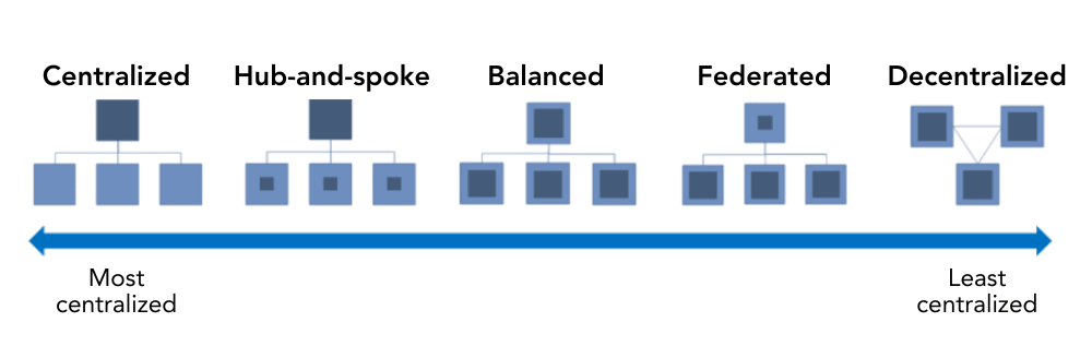
Review the information you have collected so far and compare your organization with the GIS organizational models. Which one is closest to how you have organized your GIS service delivery and resources? Keep in mind that GIS resources are not always formally organized; things may have simply evolved this way. Yet it is still worthwhile to identify a comparable organizational model so that you know where you’re starting.
Identifying gaps
By evaluating your current workforce, you have described your current state of GIS service delivery. The next step is to identify gaps by comparing your current state to where your organization wants to take its GIS capabilities. If you have a GIS strategy, you can use your strategic objectives as a reference because they describe a future state for GIS in concise terms.
Tip: if you haven’t yet defined a GIS strategy, consider following the guidance in our Geospatial Strategy Essentials for Managers series or contact our Management Consulting team for more information.
If you don’t have a GIS strategy to refer to, consult your organization’s strategic plans. If you have a data management or IT plan, these may be particularly helpful. Try to identify any strategic goals that are relevant to GIS services or geospatial data. You can also consult your leadership team to find out how they see GIS evolving and contributing to the organization.
Your current and future state descriptions don’t have to follow a particular template or format. They might be descriptive, be written in concise point form, or include diagrams and references to other documents maintained by your organization. Whatever your approach, try to include the following elements in your current and future states:
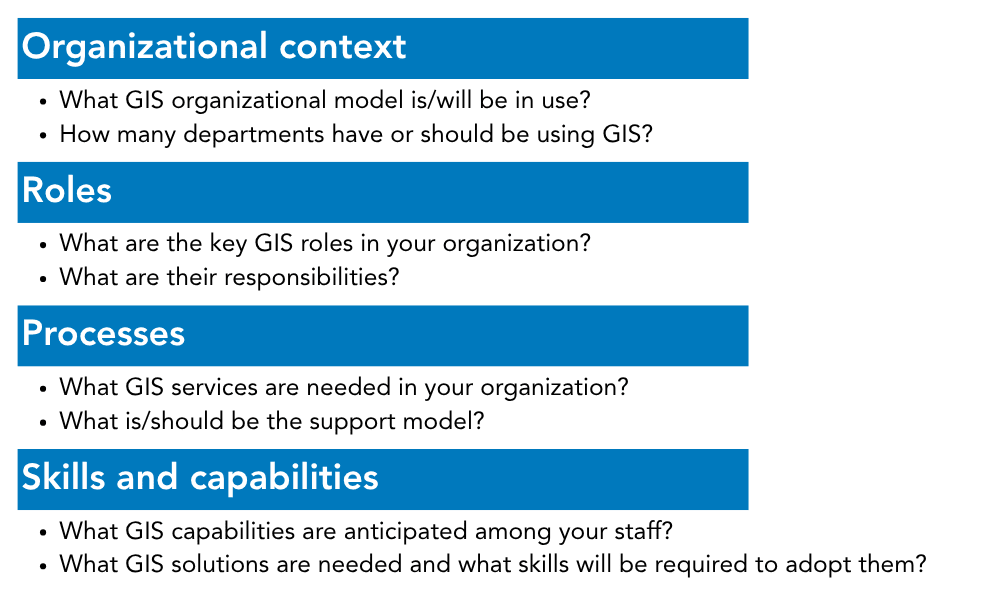
Focusing on roles
It’s worth discussing GIS roles a little further. You’ve likely heard some common GIS role names, such as “GIS analyst” or “GIS technician”. But can you clearly articulate their background, skillsets, duties or responsibilities? The truth is that there are no industry-wide GIS role definitions for you to refer to. That said, I can offer several working definitions for GIS roles that you may encounter.
|
Role name |
Description |
|
GIS technician |
This role focuses on spatial data creation, maintenance and management. They often build and publish or share maps and may be involved in data capture and processing. |
|
GIS analyst |
This role will fulfill a range of activities including cartography, geospatial data analysis, and building maps and applications. They are generally very proficient with desktop GIS software and often have some coding knowledge including scripting and process automation. |
|
GIS business user |
A professional who may not have a background in GIS but makes significant use of desktop or web applications and relies on geospatial data. |
|
GIS power user |
An advanced user of GIS whose experience has led to a high level of proficiency with GIS software. They can often build their own maps and do intermediate geospatial data analysis. |
|
GIS administrator |
A key support role requiring a substantial background in GIS. Their primary duties are supporting GIS platforms including user and permission management, publishing of maps and applications, and upgrading or maintaining platform implementations. |
|
GIS coordinator |
A front-line management role that supports GIS staff. Coordinators have a combination of GIS and supervisory skills. |
|
GIS manager |
A group manager who generally leads a GIS centre of excellence or service delivery unit. Along with a GIS background, GIS managers typically have substantial management training and experience. |
Feel free to use these, but take care to adjust the descriptions to fit within the context of your organization. Also bear in mind that you may need to define other GIS roles to best describe your current and future states.
Now, with current and future state descriptions in hand, you can proceed to a gap analysis. But I’ll take you through that process in the next post in this series, coming soon. In the meantime, if you’ve been inspired to undertake a GIS workforce assessment in your organization, please reach out—Esri Canada’s Professional Services team can help.