From Months to Weeks: Accelerating Infrastructure Planning with ArcGIS and Pathfinder
Dillon Consulting Limited combines its planning expertise with Gilytics’ route-optimization technology and Esri’s geospatial platform to make infrastructure decisions faster, more transparent, repeatable, and defensible.
Transmission-line routing can take months-or even years-before an environmental assessment begins. By combining ArcGIS with Gilytics’ Pathfinder platform, Dillon Consulting has created a connected, interactive workflow that helps project teams evaluate alternatives more quickly.
That philosophy is reflected in the work between Dillon Consulting Limited (Dillon), Gilytics, and Esri Canada. Together, these organizations demonstrate how consulting expertise, specialized routing technology and geospatial infrastructure can support clearer, more consistent and more efficient infrastructure planning processes.
For utilities and infrastructure organizations, one of the industry’s most persistent challenges is how to locate, evaluate, and advance major projects faster while maintaining the rigour, transparency and stakeholder confidence required for complex decisions.
What began as a search by Dillon for a better routing and siting solution has evolved into an example of how organizations can use the ArcGIS ecosystem to connect technologies, data, analysis, and communication in support of stronger planning outcomes.


Turning a Project Challenge into a Partnership Opportunity
In 2022, Dillon, a Canadian business partner in the Esri Partner Network (EPN), was facing a challenge familiar to many engineering organizations.
Transmission line routing studies often required up to 18 months before an Environmental Assessment (EA) process could begin. Teams relied on static reports, complex appendices, and workflows that were difficult for clients, stakeholders and regulators to understand or validate.
"Traditionally, environmental routing and siting across the industry felt like working inside a black box," recalls Brandon Fox, Partner and National Environmental Planning Discipline Lead at Dillon.
Looking for a better approach, Fox discovered Pathfinder, Gilytics' infrastructure routing and siting platform. After an initial pilot project, Dillon quickly recognized its potential.
Route creation processes that previously took one to two years could now be completed in weeks, giving stakeholders more opportunity to be involved with different stages of analysis and maintaining the transparency and rigour required for complex infrastructure projects.
Just as important, the pilot demonstrated the value of combining Dillon's expertise, Pathfinder's advanced route and site selection capabilities, and Esri's geospatial technology within an integrated workflow.
The Technology Stack Behind Faster Decisions
At the centre of the process is the connection between ArcGIS and Pathfinder.
Projects begin in ArcGIS Pro, where Dillon prepares project data, builds standards, custom tools, and templates, and assembles the environmental, engineering, and socioeconomic datasets required for analysis.
Data then moves into the Pathfinder environment, where route and site selection analyses are performed using advanced optimization models and algorithms to support project teams in their decision making. As a technology integration partner, Gilytics is able to build and deploy ArcGIS-ready solutions that integrate seamlessly with existing Esri implementations.
One particularly valuable capability is Pathfinder's tower-spotting functionality, which helps identify potential transmission structure locations during early planning stages.
Once routing options are generated and evaluated, results can flow back into the broader ArcGIS ecosystem, supporting EAs, stakeholder engagement activities, public consultation portals, interactive maps, and project reporting.
"Esri underpins the entire process," says Fox. "It's so embedded in our project delivery environment that sometimes we take it for granted, but it's the foundation that enables everything else."
The result is a connected digital process that reduces manual handoffs, improves collaboration, and helps project teams make better decisions faster.
Bringing Complementary Capabilities to Infrastructure Project Delivery
While the technology integration is important, the broader story is how complementary expertise can help organizations address complex planning challenges.
Dillon and Gilytics have demonstrated how environmental planning expertise, advanced route optimization, and geospatial technology can come together within an integrated workflow. Each organization contributes a different part of the process, from understanding regulatory and project requirements to modelling alternatives and communicating results:
- Dillon contributes environmental planning and geospatial expertise, engineering knowledge, regulatory experience and client context.
- Gilytics provides Pathfinder's routing and siting capabilities, optimization models, viewer portal, and ongoing product innovation.
- Esri technology provides the spatial foundation for data preparation, analysis, mapping, visualization and integration across the broader project workflow.
This complementary approach allows infrastructure teams to assess project constraints more holistically. Data can be prepared and managed in ArcGIS, route and site selection scenarios can be evaluated in Pathfinder, and results can be brought back into static and interactive maps, dashboards, reports and engagement tools that support broader communication with clients, stakeholders and regulators.


The process has also opened the door to broader project conversations. What may begin as a routing or siting discussion can expand into an EA, stakeholder engagement, digital delivery, geospatial modernization and long-term infrastructure planning.
For Esri Canada, this reflects the value of an open partner ecosystem: enabling organizations to build on, integrate with and extend geospatial technology in ways that help customers solve real-world business problems.
From Months to Weeks: Delivering Measurable Business Results
The business impact has been significant. Routing studies that once required up to 18 months can now be completed in as little as two to four weeks, allowing EA processes to begin much earlier and accelerating overall project timelines.
The benefits extend well beyond speed.
As projects become larger, more complex, and subject to increased regulatory scrutiny, infrastructure owners and utility organizations need planning processes that are transparent, repeatable, and defensible. By combining geospatial technology, advanced optimization and industry expertise, organizations can evaluate alternatives more consistently, engage stakeholders more effectively and make capital investment decisions with greater confidence. Built on a common spatial platform, the workflow connects data, analysis, stakeholder engagement and project communication within a single decision-making environment.
By integrating specialized solutions such as Pathfinder with ArcGIS, organizations can establish a more scalable process that improves decision quality, reduces project risk and strengthens stakeholder confidence throughout the project lifecycle.
The result delivers greater value at every stage:
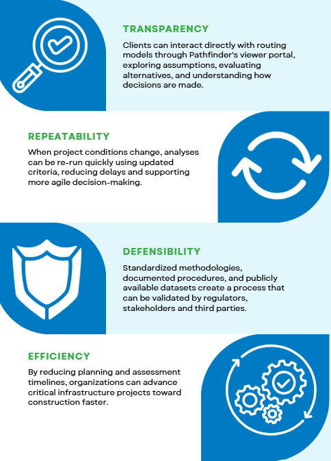
According to Dillon, clients-frequently-leave demonstrations impressed by the speed and clarity of the process, particularly the ability to complete complex analyses quickly while-maintaining-a defensible methodology.
Expanding the Solution Beyond Transmission Projects
What started with transmission line routing has evolved into a broader infrastructure project planning approach.
Today, Dillon is applying the combined Esri and Pathfinder approach to:
- Substation siting
- Operational facility siting
- Transportation and road network planning
- Utility corridor assessments
Future opportunities may include renewable energy projects, pipelines, rail infrastructure, and digital project delivery environments.
The team is also exploring innovative approaches to incorporating Indigenous knowledge and cultural heritage considerations into planning processes. Using Esri technology and working in close alignment with Indigenous partners and community protocols, Dillon can create datasets that reflect community values while helping protect sensitive information. These datasets can then be incorporated into Pathfinder analyses, supporting more inclusive and informed decision-making.
Each organization brings a distinct strength to the table, but the greatest value comes from how those strengths complement one another.
For Dillon, the workflow provides access to innovative technologies that help clients address increasingly complex infrastructure planning requirements.
For Gilytics, working with Dillon provides insight from a consulting organization applying Pathfinder to real-world infrastructure projects, helping inform future product development and use cases.
For Esri Canada, the collaboration demonstrates how organizations can use the ArcGIS ecosystem as a common spatial platform for data, analysis, visualization and communication.
As Laura Kitchen, GIS Analyst at Dillon, explains:
"The opportunity to collaborate has helped us see what is possible and highlights the reliability, transparency, and efficiency of the whole process."
Fox adds:
"We are not a status quo firm. The partnership with Esri and with Gilytics allows us to find new ways of bringing value to our clients – using technology to scale, keeping our clients at the centre, and solving real-world problems together."
From Gilytics' perspective, successful partnerships begin with alignment and trust.
"The technological opportunities from there are almost infinite," says Philippe Bieri, Co-founder, Gilytics.
“What stands out about this collaboration is the shared focus on helping customers make better infrastructure decisions,” says Brad Ashley, Industry Manager, AEC at Esri Canada. “The partnership brings together the right expertise, technology and delivery experience to reduce complexity and increase transparency. It also gives project teams a more scalable way to plan, evaluate and advance critical infrastructure projects.”
Building the Future of Infrastructure Project Planning Together
As infrastructure organizations face increasing pressure to deliver projects faster, engage stakeholders more effectively and navigate complex regulatory environments, the need for connected, transparent and repeatable planning processes continues to grow.
The work between Dillon and Gilytics demonstrates how industry expertise, specialized analytics and geospatial technology can come together to support better infrastructure investment decisions.
It is an example of how organizations can use a common spatial platform to evaluate options more clearly, analyze alternatives more effectively, communicate decisions more transparently and help clients move critical infrastructure projects forward with greater confidence, clarity and speed.
Continue the Conversation
Every infrastructure project presents unique planning challenges.