GIS Projects: Triaging Considerations Series - Part 1
Feeling overwhelmed by multiple GIS project requests? You're not alone! In this 6-part series, I'll introduce a 6-pillar framework to help you navigate and prioritize these projects effectively. Part 1 dives into the bigger picture of Return on Investment (ROI). By the end of the series, you'll have a handy guide to assist you in triaging projects, making the process smoother and more manageable. If you stay tuned until the end, I’ll also include a cheat sheet to help.
Before we begin, it's important to note that this framework is based on my experiences as a consultant and technical solutions specialist. It draws from personal project-level experience and relative risk assessments and may not fully align with your organization's stance on technology, training and capacity, business workflows or security and privacy.
Some of these topics and themes are available as services from our Management Consulting team.
The Scale
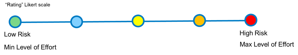
Graphic of Image likert Scale
I will be using a Likert-style sliding scale to easily and generally visualize risk or effort. Lower risk and lower effort will typically be green, transitioning to red for higher risk and/or higher levels of effort.
In some cases, depending on your IT policies, what I consider low risk may be high risk. For example, if you work for a local government that is averse to open data (yes, these organizations do exist), having publicly available data and apps in the cloud may be high risk to the Mayor and Council. Conversely, a neighboring municipality with an open data program may view it as low risk. So, your mileage may vary (YMMV).
The Six Pillars for GIS Project Triage Consideration
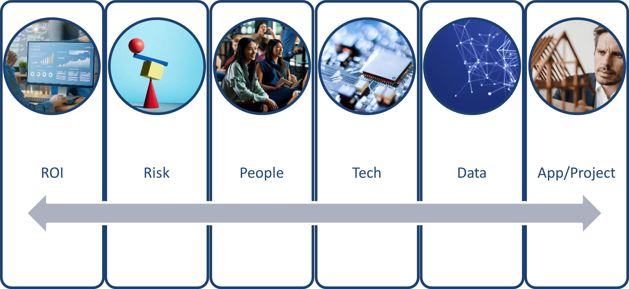
Framework for triaging contains 6 pillars
In this framework, we consider six essential pillars or themes when evaluating a possible GIS project:
- Return on Investment (ROI): Does the project have a tangible return on investment?
- Risk: What associated risks are anticipated with the project?
- People: What capacity is required for the project and its sustainment throughout its typical lifecycle?
- Technology: What pieces of technology or equipment are required to ensure the project's success?
- Data: Is the data involved in the project accurate, secure, accessible, and timely?
- Application & Project: What are the project deliverables, outcomes, and measures of success?
To properly evaluate a project, we should conduct at least a rudimentary survey of its merit within this framework. Each pillar will be explored in its own blog post.
Understanding Return on Investment

Understanding ROI
ROI Triad
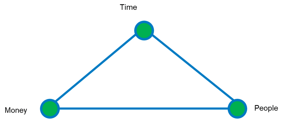
Understanding the ROI Triad
The graphic above illustrates the return on investment (ROI) in terms of Time, Money and People. In the context of a municipality publishing an application publicly or procuring location-based public works and utilities software, consider the following:
- Time: Will it reduce taxpayer and constituent wait times for accessing information or processes? Will this new application increase time efficiency for staff and contractors?
- Money: Will this project save taxpayer money? Or will it help generate more revenue through increased permitting volume? Could a new pay-parking app boost revenue?
- People: Ideally, our applications should invest in our people, whether internal staff or stakeholders. For example, does this new application fulfill our accessibility commitments? Will it empower self-service, thereby reducing queue wait times at the counter? Most organizations have a corporate vision or mission statement regarding their staff and the stakeholders they serve – will this application align with that mission?
The triad is all green – each component should be considered equally.
Understanding the Objectives Within the Geospatial Strategy context
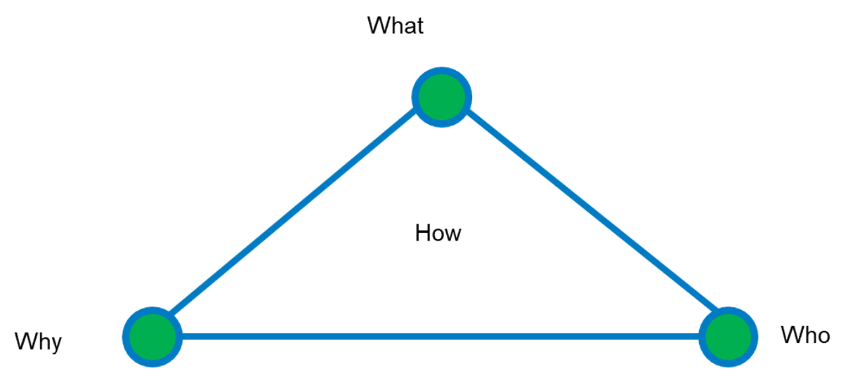
Understanding the objectives within a geospatial strategy
GIS professionals are solutions-oriented people. When faced with a challenge, we tackle it head-on. However, it's sometimes beneficial to pause and consider how a new project aligns with a corporate geospatial vision or strategy. Not sure what that is? Don't have one? We can help.
An organizational geospatial vision or strategy sets the tone and framework for using GIS to enhance decision-making, improve efficiency, manage resources better, increase competitiveness, reduce organizational risk, and enhance collaboration.
In this context, we can assess the merits of a project using some key questions:
- What: What business problem does this project solve? What changes will it bring to the organization if implemented? What organizational objectives does it impact?
- Who: Who is the executive sponsor or champion? Who is requesting the project? Who are the other stakeholders involved and who will be affected?
- Why: Why is this project critical? Why now? Why the change?
- How: How can we successfully deliver this project on time and within budget?
While "Where" and "When" are equally important, they are addressed more in-depth in later posts.
Understanding Measurable Outcomes and Success

Understanding measures of success
To quantify the return on investment (ROI), we need to consider the metrics used to assess the project. Based on my experience, I've identified five themes to assign metrics to, allowing us to validate the ROI:
- Improved Performance: For a GIS project upgrading hardware and software, will we see a 15% improvement in hardware response time? Will moving the GIS to a cloud-hosted environment reduce server downtime by 25%?
- Improved Productivity: Can users accomplish more within the same time and budget after project implementation? Will data accuracy and timeliness improve, making it more effective for users? Are we receiving more positive feedback about the new system? Is it easier to generate reports?
- Saving Taxpayer Money: For municipalities, this is crucial. In a for-profit organization, the question shifts to whether the project will increase shareholder value by generating more revenue and by how much.
- Improved Efficiency: Time is money. Will the project make better use of people's time once implemented? Are there new automation capabilities to handle repetitive tasks? Will implementing generative AI in ArcGIS speed up app development? Can GeoAI for object segmentation and classification increase the efficiency of tasks like pavement marking inventory?
- Improved Service Delivery: The GIS department serves internal departments and the public. Will stakeholders experience better GIS services with the project? For example, if a municipality implements targeted web map applications for different use cases instead of a "kitchen sink" approach, will this increase public engagement?
It's important to understand how a project can provide a positive ROI because it ensures that resources are being used effectively and that the project contributes to the overall goals and success of the organization. By demonstrating a positive ROI, you can justify the investment, gain stakeholder support and make informed decisions about future projects.
Understanding how a project provides measurable ROI is essential as a baseline for discussing other topics in subsequent posts. In my next post, I will explore how we can evaluate potential GIS projects in the context of risk analysis.