The Executive Case for GIS in AEC: Unlocking ROI & Long-Term Value
With the technical foundation of Esri and Autodesk integration established in our last post, organizations must now consider the business impact of these technologies. Beyond operational benefits, GIS delivers measurable financial value, improves risk management and positions firms for long-term success. In this final installment of our blog series, we will examine the executive perspective on GIS adoption, focusing on its return on investment (ROI) and strategic advantages for AEC and Environmental firms.
Overview
For executives in the Architecture, Engineering and Construction (AEC) industry, investments in technology must be justified through measurable returns. Geographic information system (GIS) technology has evolved beyond traditional mapping tools to become a strategic asset that drives efficiency, cost savings, risk mitigation and competitive advantage.
In both AEC and Environmental sectors, GIS adoption is transforming how firms analyze, plan, design, construct and maintain infrastructure. However, executives and senior leadership must consider the broader impact of GIS on operational efficiency, long-term sustainability and financial performance.
This post explores how GIS delivers return on investment (ROI), the key challenges to adoption and the strategies executives can use to maximize their Esri partnership.
The business case for GIS in AEC
Executives evaluating new technology must weigh the upfront investment against long-term gains. GIS adoption in AEC has proven to deliver measurable financial and strategic value across various business functions.
1. Cost savings and operational efficiency
One of the most direct ways GIS generates ROI is by streamlining workflows, reducing redundancies and eliminating inefficiencies.
-
-
Reduced rework and errors: GIS provides a single source of truth for geospatial and project data, ensuring that teams work with accurate, real-time information. This reduces errors caused by outdated blueprints or conflicting datasets, preventing costly rework.
-
-
-
Automated data collection & analysis: GIS tools eliminate manual surveying and reporting processes, reducing labour costs and accelerating project timelines. For example, drone-based GIS surveys can replace weeks of fieldwork with automated, high-resolution data collection in hours.
-
-
-
Optimized construction planning: GIS-driven site selection analysis helps firms avoid costly mistakes, such as building in flood-prone areas or violating zoning restrictions. By identifying potential conflicts early, GIS reduces unexpected costs and delays.
-
2. Health and safety risk mitigation
AEC firms operate in environments where worker safety is a top priority and failure to manage risks effectively can lead to serious injuries, regulatory violations or project delays. GIS provides a proactive approach to health and safety by identifying hazards, improving emergency response and ensuring compliance with safety regulations.
-
-
Worksite hazard identification & mitigation: GIS helps map high-risk areas such as unstable terrain, hazardous materials and restricted zones, enabling teams to implement targeted safety measures.
-
-
-
Regulatory compliance & safety reporting: GIS streamlines the collection and submission of health and safety reports, environmental impact assessments and land use permits, ensuring adherence to workplace safety regulations.
-
-
-
Emergency preparedness & response: By integrating GIS with real-time weather data, sensor networks and historical incident reports, firms can anticipate risks like extreme heat, flooding or structural instability, enhancing on-site emergency planning.
-
-
-
Hazard management & safe routing: GIS enables the geofencing of hazardous or restricted areas to support safe route planning for field crews. By dynamically mapping risks and environmental conditions, organizations can reduce exposure to danger, ensure compliance and improve emergency preparedness.
-
3. Improved asset lifecycle management
Infrastructure and building assets require long-term management, and GIS provides a comprehensive digital twin of physical assets to assess conditions, usage and risks. This enables proactive maintenance, improves reliability and maximizes investments.
-
-
Real-time asset monitoring: GIS integrates with IoT sensors, drones, and field inspections to monitor asset conditions continuously. This enables predictive maintenance, reducing downtime and preventing catastrophic failures.
-
-
-
Optimized resource allocation: GIS helps executives prioritize maintenance investments, focusing on high-risk or high-value assets first.
-
-
-
Extended asset lifespan: By enabling data-driven maintenance schedules, GIS extends the life of bridges, roads, utilities and facilities—reducing costly replacements.
-
4. Competitive advantage and market differentiation
Firms that embrace GIS gain a strategic advantage over competitors who rely on outdated data and disconnected workflows.
-
-
Faster project delivery: GIS accelerates feasibility studies, environmental approvals and construction planning, enabling firms to complete projects faster and win more contracts.
-
-
-
Smart infrastructure and digital transformation: Leading firms use GIS to integrate AI, machine learning and automation, positioning themselves as industry innovators.
-
-
-
Enhanced client engagement: GIS-powered visualizations allow executives to provide interactive 3D project models to investors, government agencies and stakeholders—building trust and winning bids.
-
-
-
Expanding market opportunities: Firms can leverage Esri’s selling programs and partner network to develop digital solutions that differentiate their offerings, capture new markets and maximize revenue from existing clients.
-
Challenges to GIS adoption in AEC & Environmental sectors
Despite its clear benefits, some firms struggle with GIS adoption due to technical, organizational and financial barriers.
1. Upfront investment costs
-
-
Executives may hesitate due to software licensing fees, training costs and the need for skilled personnel.
-
-
-
Solution: A phased implementation approach—starting with pilot projects—helps firms measure ROI before full-scale deployment. Ensure you are using the right tool for the right job.
-
2. Resistance to change
-
-
Many AEC firms rely on traditional CAD/BIM workflows and resist integrating GIS into their processes.
-
-
-
Solution: Leadership must demonstrate innovation via quick wins, such as reducing manual data entry or eliminating redundant workflows, to gain internal buy-in.
-
3. Data silos and integration challenges
-
-
GIS data often exists in fragmented systems, making it difficult to integrate with Autodesk, BIM or ERP software.
-
Solution: Investing in Esri-Autodesk integration tools, such as ArcGIS GeoBIM or other functionality that creates a seamless connection between design and geospatial data.
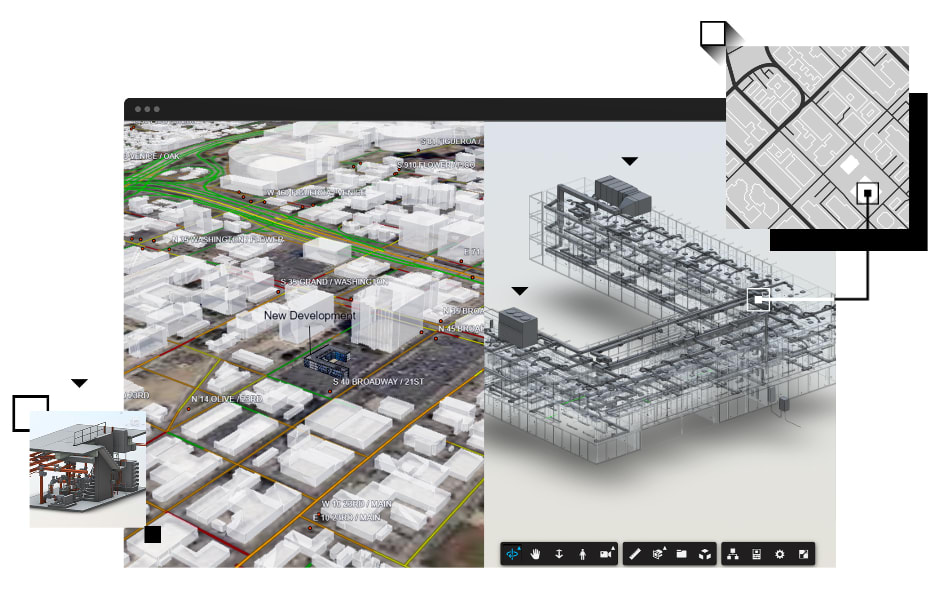 Unifying GIS and BIM to transform workflows and build a better future
-
4. Lack of GIS expertise
-
-
Many firms lack in-house GIS specialists, making adoption difficult.
-
-
-
Solution: Partnering with GIS consultants, investing in training programs and leveraging cloud-based GIS solutions can bridge the expertise gap.
-
Maximizing ROI: A strategic roadmap for executives
To ensure a high return on investment, firms must take a structured approach to GIS adoption.
1. Align GIS with business goals
-
-
Define clear objectives: Are you aiming to reduce costs, improve project timelines or enhance sustainability?
-
-
-
Establish KPIs to track GIS-driven improvements in efficiency, risk reduction and profitability.
-
2. Start with high-impact use cases
-
-
Identify low-risk, high-value applications (e.g., GIS-powered site selection, automated permit processing or drone-based land surveys).
-
-
-
Deliver quick wins to demonstrate value before scaling GIS across the organization.
-
3. Invest in training & change management
-
-
Upskill current staff through training programs, certifications and workshops on GIS-BIM integration.
-
-
-
Develop an internal GIS centre of excellence to drive best practices and knowledge sharing.
-
4. Leverage cloud and AI for scalability
-
-
Cloud-based GIS solutions reduce IT infrastructure costs while enabling real-time collaboration across global teams.
-
-
-
AI-driven GIS analytics automate workflows, enhancing predictive maintenance and risk assessment.
-
5. Measure ROI continuously
-
-
Use dashboards to track GIS adoption metrics, including cost savings, project speed and risk reduction.
-
-
-
Continuously refine GIS strategies based on performance data.
-
Conclusion
For AEC and Environmental sector executives, GIS is no longer just a mapping tool—it is a business-critical technology that drives cost savings, efficiency and competitive advantage.
By investing in GIS-powered workflows, asset management and risk mitigation strategies, firms can future-proof their operations, improve project outcomes and gain a measurable return on investment.
Executives who embrace GIS position their organizations as industry leaders, ready to compete in an increasingly data-driven and digital-first world.
Now is the time to move beyond traditional workflows and unlock the full potential of GIS in AEC and Environmental sectors.
This concludes our blog series, which has explored GIS adoption from three perspectives—industry trends, technical integration and executive strategy. As AEC and Environmental firms navigate the evolving digital landscape, those who invest in GIS will gain a competitive advantage through improved efficiency, cost savings and better decision-making.
Whether your organization is just beginning its GIS journey or refining its existing workflows, the key takeaway is clear: GIS is not just an innovation—it is a necessity for future success. We encourage you to continue exploring, implementing and optimizing GIS solutions to drive real business value.
Questions? Contact us at esri.ca/aec
If you have questions or want to discuss how GIS can support your projects, connect with our team at Esri Canada.
See how Esri technology drives real-world success: esri.ca/aec