School Boards and ArcGIS StoryMaps: My Co-op with Esri Canada
What is it like being a co-op student at Esri Canada? Discover how Sarah Paquin gained insight, confidence, and real-world GIS skills in just four months.
Sarah's experience
I was taught that you can’t learn GIS without throwing yourself into the deep end, and that is exactly what I did during my term at Esri Canada.
This semester I had the opportunity to join Esri Canada’s Education and Research team as a co-op student. During my 4-month stay with the company, I was treated as a full-fledged employee within the department, participating in meetings and social gatherings, and working independently on high-level projects. I learned from experts about constructing large and complex datasets, educating partners about Esri’s products, and working in a professional environment.
I am currently a student at McMaster University where I am pursuing an Honor’s Environmental Sciences degree (B.Sc.) with specializations in both Urban Studies and Planning and GIS. As someone who only learned of GIS during my bachelor’s degree, I was very excited at the prospect of helping to teach those in K-12 education settings about these technologies and their power. Education has long been an important part of my life, as the daughter of two teachers turned principal and curriculum specialist. I am an emergency supply teacher during the summers and a teaching assistant at McMaster University during the fall and winter semesters, making the Education and Research department a perfect fit for my first co-op term.

The co-op term with Esri Canada’s Education and Research group was great, but it went by so quickly.
Dataset Compilation
My primary project this term was the construction of two large datasets: comprehensive collections of all school boards, and all schools in Canada. These datasets are useful for Esri Canada internally, but also for provincial and territorial governments, municipalities, and external organizations. They represent an important contribution from Education and Research to the company’s geospatial infrastructure collection.
In the construction of the School Boards dataset, I became adept at compiling polygon layers from various sources and combining them to produce a unified, polished result. Throughout this project I developed my skills in ArcGIS Pro, and my understanding of federal and provincial educational structures across the country. Each entry in the School Boards dataset includes enrollment information and a field indicating the date to which this figure is accurate, which will allow the data to be maintained and continue to be useful for years to come.
School board structures differ across the country. While some provinces have Catholic school boards (Ontario, Saskatchewan and Alberta), others do not and instead include Catholic schools as either private schools or in public school boards. Ontario is the only province that has a French Catholic school board.
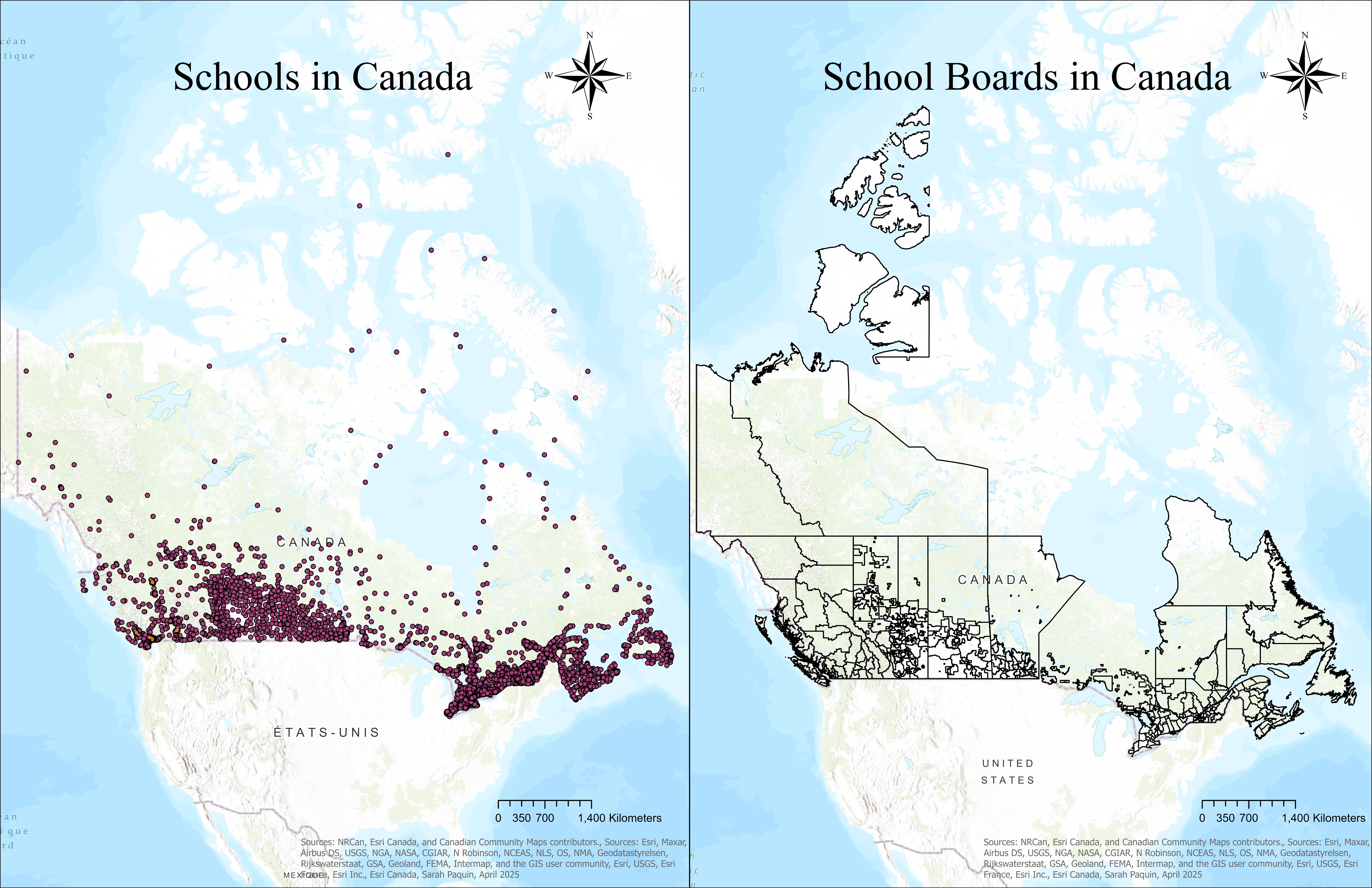
As can be seen on the School Boards in Canada map below, there are some open spaces that do not appear to be included in any school board’s jurisdiction. In Northern Ontario, any schools not covered by a school board are Indigenous schools managed either federally or by individual Indigenous groups. Any public, catholic, French, or French Catholic school in the province is included in one of the defined school boards. In Nunavut, school boards do not have defined boundaries. They are included in the dataset without geometry.

Locations of all public and private schools for primary and secondary education in Canada (left) and boundaries representing Canadian school boards (right).
The second dataset encompassing every primary and secondary school was a much larger undertaking. With over 15,000 schools across the country, Canada’s education system extends beyond public schools and includes Catholic, French, Indigenous, and private schools all under different forms of administration and service. As such, the data for this layer came from hundreds of sources and took roughly two months to compile.
For this project, I started from a dataset that was last updated in 2016, correcting pre-existing errors and updating it based on school closures and openings that had occurred in the past nine years. I am pleased to say that the final product is more than worth the time taken to construct it, as this comprehensive dataset of schools has already been utilized by several education partner organizations for important work in education and beyond. One of the initiatives is using this data to map nature in and around schools in British Columbia to increase access to nature for children.
Other Projects
I was involved in several other projects this term, two of which included giving presentations on ArcGIS StoryMaps to different organizations under the leadership and guidance of Susie Saliola and Tatum Pascal, whom I worked alongside in the Education and Research department.
Another project tied into one of the goals of the Education and Research department this year, to integrate our technology into other disciplines in higher education, specifically targeting public health. I worked closely with Esri Canada's Public Health department to conduct research on current bachelor's and master's public health programs in Canada, and then created a GIS tutorial targeting these groups.
What’s Next?
As I look into the future of my career in GIS, I am excited to be part of the executive committee hosting an upcoming geomatics competition at McMaster University. I will be working with professors and industry professionals to develop a theme for the competition and will be assisting with the logistical side of the event as well. Esri Canada was a sponsor of the competition in 2025, so I look forward to working with the company again to promote the event in 2026. My next co-op position for this spring term will be with the GIS department in the Kingston, Ontario area, where I will be in a field-work-based position working at the municipal and regional level on various projects.
All in all, working at Esri Canada’s Education and Research department was an incredible opportunity.