Maximum City receives Esri Canada’s Making a Difference Award
Toronto-based company recognized for transforming youth civic education and engagement using advanced mapping technology
TORONTO—November 18, 2025—Esri Canada today presented the 2025 Making a Difference Award to Maximum City, a Toronto-based urban education company that is transforming how young people shape the future of cities by using geographic information system (GIS) technology. Through innovative programs and hands-on experiences, Maximum City empowers youth to become active participants in urban planning and systems change, leveraging advanced mapping tools to visualize, analyze and communicate their ideas for healthier, more sustainable communities.
“Maximum City’s pioneering programs give youth a voice in urban planning and policy and tap into their unique creativity to improve the world,” said Alex Miller, president, Esri Canada. “Their outstanding use of GIS demonstrates how the technology contributes to improving civic education and society, engaging youth in building more equitable, greener and more vibrant Canadian cities.”
Maximum City’s programs involve youth in real-world urban problem solving—from reimagining streetscapes to evaluating the impact on youth of major events like the upcoming Men’s FIFA World Cup 2026. Their YouthScore Engagement and Mapping Tool, developed using Esri’s ArcGIS Online software, includes a web-based survey and map that assesses the youth-friendliness of urban places in different categories. An ArcGIS StoryMaps story developed by Maximum City was used to engage youth in the renewal of Toronto’s official city plan, particularly around climate change. Young people’s input was incorporated into policy, including the creation of advisory bodies with designated seats for youth members.
“Young people have the longest future and farthest horizon in our cities. It’s essential that youth voices are front and center in city-building decisions since they will live with the consequences the longest,” says Josh Fullan, executive director of Maximum City. “GIS tools allow young people to connect to place and collect and visualize data about their neighbourhoods, making complex environments easier to understand and improving their ability to advocate for positive change.”
By using GIS mapping applications, students can compare their own experiences—such as feelings of safety, access to green spaces and ease of movement—with objective data like air quality and heat stress. This evidence-based approach not only informs better planning but also gives youth a direct role in shaping their communities.
“Maps and dashboards are powerful tools for communication and connection,” Fullan explains. “They help young people develop spatial awareness, systems thinking and digital skills that are increasingly valuable in today’s workplaces. More importantly, these tools foster a sense of stewardship. When youth are connected to place, they care about it and want to make it better.”
Explore Maximum City’s programs at maximumcity.ca
Learn more about GIS at esri.ca/gis
About Maximum City
Maximum City works at the intersection of urbanism and education, collaborating with cities, schools, and nonprofits to increase agency and build stronger connections—between people, to places, to data and decision making. As child and youth participation experts and IAP2-trained facilitators, the company designs deep learning experiences, facilitates rich engagement processes, develops digital tools for change, and crafts context-sensitive strategy and solutions for clients. Learn more at maximumcity.ca
About Esri Canada
Founded in 1984, Esri Canada provides geographic information system (GIS) solutions that empower people in business, government, and education to make informed and timely decisions by leveraging the power of mapping and spatial analytics. These solutions enable organizations to better manage their resources, plan their future and collaborate within and beyond their organization. Esri Canada’s products and services help advance successful digital transformation. The company serves more than 14,000 organizations from 14 offices across Canada and is based in Toronto. Esri Canada has been recognized as one of Canada’s Best Managed Companies for 13 consecutive years. More information can be found at esri.ca. Follow Esri Canada on X (Twitter), Facebook, YouTube, Instagram and LinkedIn.
For media inquiries, please contact:
Maximum City
team@maximumcity.ca
Esri Canada
press@esri.ca
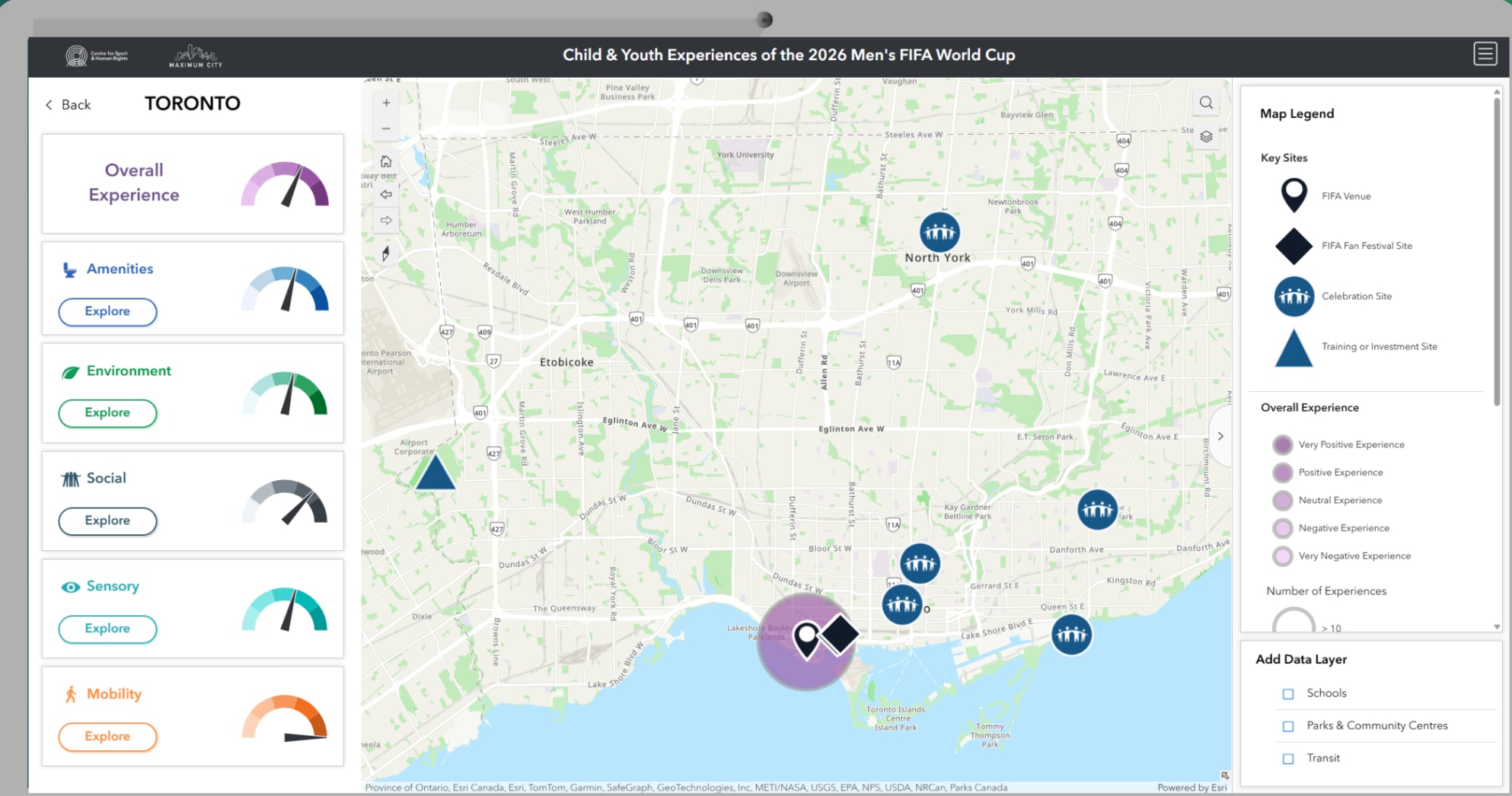
This dashboard visualizes how young people rate their experiences in relation to the upcoming Men’s FIFA World Cup 2026, combining subjective survey data with objective metrics like air quality and heat stress.
Watch this video to learn more about Maximum City’s community impact.