Getting Technical – September 2025
When is GIS Day in Canada? How do I get tickets to Canada’s largest national event for the GIS community? How do I get started using ArcGIS Experience Builder? What are RSS feeds and how do you use them with Esri applications? How do you use the ArcGIS StoryMaps Assistant? Get answers to all these questions and more in this month’s edition of Getting Technical.
Must Reads

Save the date for GIS Day in Canada
GIS day in Canada
GIS Day in Canada is coming up on November 18, 2025! This is a fantastic opportunity to discover how the "where" in your data can open up new avenues for you.
Leaders from various industries, including the municipal sector, retail and urban development, are tapping into location intelligence to uncover trends and enhance their decision-making. Gone are the days of mapping specialists working alone in a closed-off department. Now, location is helping "geo-generalists" craft targeted strategies that help their organizations better connect with people.
On November 18, we'll explore exactly how this is happening, thanks to inspiring stories from Canadian leaders from all different industries. Join us to discover how we can all benefit from becoming geo-generalists!
Register now: GIS day in Canada
Esri Canada Federal GIS Conference
October 7, 2025 | Ottawa, Ontario
This exclusive event explores how the Federal government is using the geographic approach to derive powerful insights and make data-driven decisions for all Canadians. We are happy to share that we are at capacity for this event! Our waiting list is now full, and we will not be accepting in-person registrations. If you are registered and are no longer available to attend, kindly inform us at conferences@esri.ca to allow others on the waitlist to attend. See our detailed agenda here.
Esri Canada User Conference is Back – Register Now!
November 3–4, 2025 | Toronto, Ontario
Join us for Canada’s largest national event for the GIS community. Don’t miss your chance to be part of the movement that’s integrating everything, everywhere to build a smarter, more connected future. Curious about the conference agenda? We’ve got you covered here.
Blogs
No code, no problem: introduction to working with ArcGIS Experience Builder-
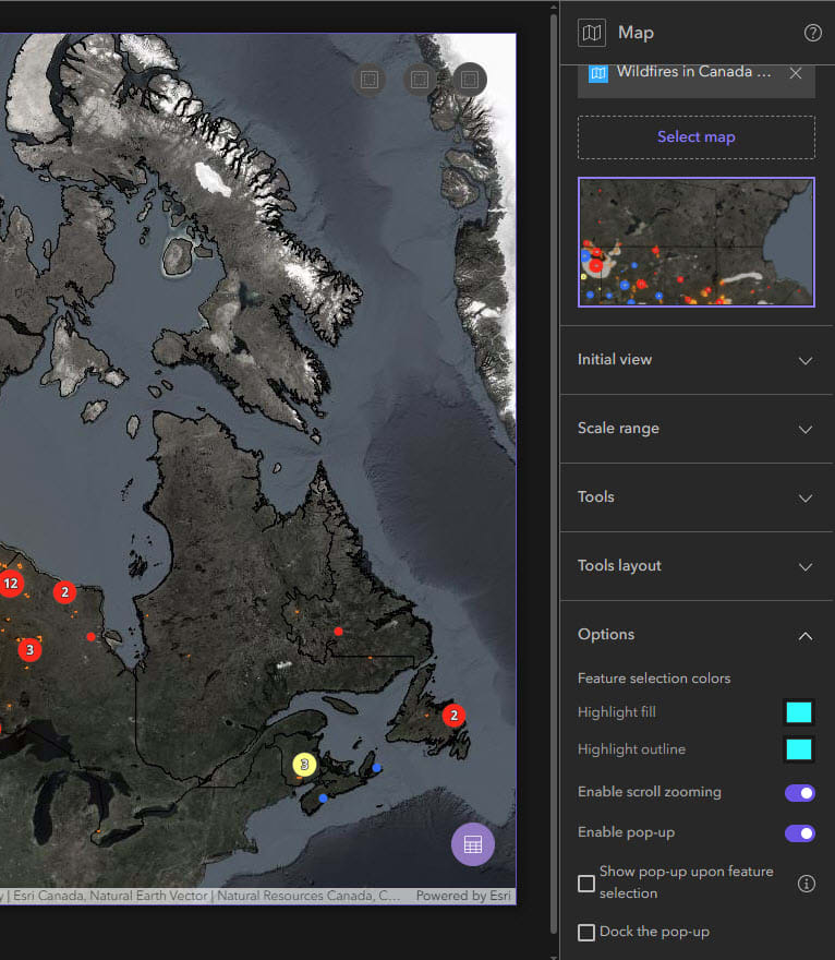
Map widget configuration panel customization options
Want to build a web app but not sure where to start? You’ve come to the right place! ArcGIS Experience Builder offers a streamlined and structured way to build your dream web app without any coding. In our recent webinar, we walked you through 6 simple steps to build your first web app. This blog will break down every step in detail.
No code, no problem: advanced workflows in ArcGIS Experience Builder

ArcGIS Experience Builder is an incredibly versatile application that users can make as straightforward or complex as they’d like. This blog highlights advanced features that will take your app to the next level. In addition to this blog, you can check out the accompanying webinar here.
Delivering real-time updates with Esri RSS feeds in Microsoft Teams
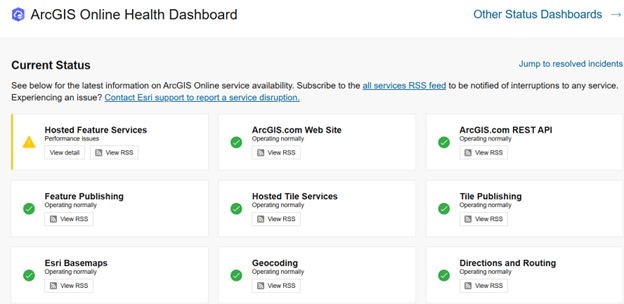
The ArcGIS Online Health Dashboard
Microsoft Teams makes it easy to connect as many RSS feeds as needed, giving your team real-time access to curated content without the need to chase down information. It’s a simple yet powerful way to keep everyone informed and focused.
View all additional blogs on the Esri Canada Blog.
Videos
Esri RSS feeds in Microsoft Teams
Want to keep your team in the loop with the latest tips, blog videos, health dashboards and more? In this GeoSnap, we show you how to integrate our branded RSS feeds directly into Microsoft Teams. With this setup, your colleagues will get automatic updates. It’s a simple way to make sure everyone stays informed and connected to the resources that matter most.
How to use the ArcGIS StoryMaps Assistant
Did you know that there is an ArcGIS StoryMaps Assistant that can be used to help make your ArcGIS StoryMaps more accessible? In this GeoSnap, we walk you through how to get started.
Stay up to date on all of our GeoSnaps by visiting the YouTube playlist.
Training
Imagery Analysis in ArcGIS Pro
Transform pixels into information
This course is for GIS and imagery professionals in the private sector and civilian government agencies who need to extract meaningful information from satellite imagery, unmanned aerial vehicle (UAV)-collected data and other imagery formats. Workflows and considerations to display, process and create derived raster products using ArcGIS Pro and ArcGIS Image Analyst are covered. You'll explore common imagery applications, including disaster recovery, damage assessment and forest canopy assessment and gain experience with the deep learning analysis workflow.
Esri Canada Seminars & Webinars
From Policy to Progress: Digital Tools for Everyday Planners
October 2, 2025

Join us for an engaging and accessible webinar designed specifically for non-technical municipal planning staff. We’ll explore how simple, user-friendly technology can support your community’s growth goals, without requiring a tech background. You will learn how digital tools can improve capacity planning as you update planning policy, connect teams across a shared planning system, build resilient communities to help mitigate climate change and support effective planning for growth in rural areas. Whether you’re working on housing, infrastructure, or long-term development plans, this session will show you how to make technology work for you.
Location Intelligence and the Smart Grid
October 8, 2025

The electricity industry is evolving rapidly with technological advances, rising demand and increasing risks. Understanding how multiple data sources can be leveraged to support operations and planning is key to success. Learn how ArcGIS and ArcFM Solution can drive location intelligence which is a key factor to support a holistic view of a utility’s business drivers. Explore how ArcFM extends the Esri Utility Network with live editing feedback, advanced network intelligence, web and mobile markups and commissioning automation. These capabilities enable fully digitized workflows that link asset health with the entire design-build-commissioning process through to operations.
Ask Me Anything: Everything You Need to Know About NG9-1-1 & GIS – Part 2
October 22, 2025

Back by popular demand, this is the second session in our NG9-1-1 “Ask Me Anything" (AMA) webinar series. We’re bringing you timely insights, peer-driven discussion and more of your questions answered.
The shift to Next Generation 9-1-1 (NG9-1-1) marks a pivotal evolution in emergency response, transforming how emergencies are managed with enhanced data communication and integration. This urgent transition is vital for improving public safety and response capabilities, necessitating swift and efficient adoption by organizations.
Join our interactive AMA session to connect directly with Esri Canada’s NG9-1-1 GIS specialists. Whether you have detailed technical questions or are seeking general insights about NG9-1-1 GIS, this webinar offers a platform to demystify its complexities and guide your organization through this essential transition.
Build Customizable Web Apps with ArcGIS Experience Builder: Easy Peasy! (in French)
October 29, 2025

This technical webinar introducing ArcGIS Experience Builder will provide you with an in-depth overview of the features of this web application creation tool. You will discover how to design interactive and customized experiences by leveraging built-in templates and widgets. Practical demonstrations and concrete examples will enhance your understanding, offering you a visual insight into application design within this intuitive interface. By the end of this webinar, you will leave with the knowledge and inspiration needed to start exploring and harnessing the full potential of ArcGIS Experience Builder!
No Tricks, Just Tips: ArcGIS Survey123 Essentials
October 30, 2025

Efficient field data collection is key for teams that rely on timely, accurate information. This session will show how ArcGIS Survey123 can help modernize your workflows. Using both the web designer and Survey123 Connect, we’ll show you how to build and customize surveys. With live demos and practical tips, you’ll learn which tool to use when and how Survey123 can streamline your field data collection.
Whether you’re just getting started or looking to improve how your team collects and manages data, you’ll find practical ideas and examples to take back with you. Join us to see what’s possible with Survey123 and how it can elevate your field data workflows!
Missed last month’s recording? No problem, check out the recordings here: View recorded seminars | View recorded webinars

Service Packs, Patches & Product Support Updates
Esri Support App
Download the Esri Support app to subscribe to important product updates and bug-related notifications. Also, try its newest feature – scan and solve error messages. You can also take advantage of Esri’s in-app generative AI chatbot to answer some of your questions. This Esri Support AI Chatbot can also be accessed on the Esri Support website.
ArcGIS Trust Center
Visit the ArcGIS Trust Center for critical security announcements and updates to privacy and compliance information.
Migrating from ArcGIS EngineArcGIS Engine is scheduled for retirement on March 1, 2026. In this post, we will delve into deprecation specifics, the impending retirement of ArcGIS Engine, strategies for planning your migration and an introduction to one of the key migration routes leveraging ArcGIS Maps SDKs for Native Apps.
ArcGIS and the Impact of MFA Enforcement in Snowflake
Announcing the Deprecation of ArcGIS Maps SDK for Local Server

Retiring Apps and Features
Below you’ll find more information about the upcoming retirement of several apps and features included in ArcGIS Online and ArcGIS Enterprise.
ArcGIS Engine is Deprecated – Migrate Now
Esri has deprecated ArcGIS Engine, including the ArcGIS Engine Developer Kit and ArcGIS Engine Runtime, to concentrate on client-application developer products that more effectively address the needs of developers within the modern ArcGIS system. ArcGIS Engine entered Mature Support on March 1, 2024, and full retirement is scheduled for March 1, 2026. No further functionality updates, patches, or hotfixes will be available.
We strongly recommend migrating to one of the following alternatives:
- ArcGIS Maps SDKs for Native Apps for desktop and mobile client applications
- ArcGIS Maps SDK for JavaScript for web applications
- ArcGIS Maps SDKs for Unity or ArcGIS Maps SDKs for Unreal Engine for immersive 3D and XR experiences
- ArcGIS Pro SDK for .NET for advanced GIS workflows
- ArcGIS Enterprise SDK and ArcPy for server-side operations and automation
For detailed guidance and resources, visit our guides on migrating:
- Migrating from ArcGIS Engine — Part 1: Deprecation and Migration Paths
- Migrating from ArcGIS Engine — Part 2: Developer Components
Web AppBuilder Retiring with ArcGIS Enterprise 12.0 and Q1 2026 ArcGIS Online Update
ArcGIS Web AppBuilder will no longer be available in ArcGIS Enterprise beginning with the 12.0 release. In ArcGIS Online, while ArcGIS Web AppBuilder will retire in Q1 2026, your existing apps will continue to function. However, after retirement you will no longer be able to create new apps or edit existing ones, and no further bug fixes or enhancements will be provided. Updates to browsers could introduce functional or security issues which will not be addressed by Esri. We recommend that you migrate your apps to ArcGIS Experience Builder. For more information, read the retirement announcement.
ArcGIS Configurable Apps Retiring with Enterprise 12.0 and Q1 2026 ArcGIS Online Update
ArcGIS Configurable Apps will retire with the release of ArcGIS Enterprise 12.0, and in ArcGIS Online beginning with the Q1 2026 update. Apps built using Configurable Apps will no longer be accessible upon retirement. We recommend you begin the process of recreating them in ArcGIS Instant Apps. For more information, read the retirement announcement.
Map Viewer (Classic) Retiring with ArcGIS Enterprise 12.0 and Q1 2026 ArcGIS Online Update
Map Viewer Classic will retire with the release of ArcGIS Enterprise 12.0, and in ArcGIS Online beginning with the Q1 2026 update. You will no longer be able to create maps with Map Viewer Classic, and maps previously saved in Map Viewer Classic will automatically be accessible from Map Viewer. We recommend that you start using Map Viewer, built on Esri’s latest web mapping technology, ArcGIS Maps SDK for JavaScript. For more information, read the retirement announcement.
Esri Story Maps Retiring in ArcGIS Online with the Q1 2026 Update
Esri Story Maps will retire in ArcGIS Online with the Q1 2026 update. At that time, Esri Story Maps will be removed from ArcGIS Online, and any stories created with Esri Story Maps will no longer be available. We recommend that you transition to ArcGIS StoryMaps now to allow sufficient time to recreate existing Esri Story Maps stories and build them in ArcGIS StoryMaps. For more information, read the retirement announcement.
ArcGIS Insights Retiring with ArcGIS Enterprise 12.0 and Q2 2026 ArcGIS Online Update
ArcGIS Insights will retire with the release of ArcGIS Enterprise 12.0, and in ArcGIS Online with the Q2 2026 update. We recommend that you evaluate your current workflows and analytics and select a product that most closely captures your needs, as there is no one-to-one migration option. For more information, read the deprecation notice.
Metadata Editor Classic Will Retire with ArcGIS Enterprise 12.0
Metadata Editor Classic will retire with the release of ArcGIS Enterprise 12.0. Metadata previously saved in Metadata Editor Classic for ArcGIS Online and ArcGIS Enterprise continues to be available using the new metadata editor. We recommend that you identify any workflows using Metadata Editor Classic and proactively begin using the new metadata editor as alternative. For more information, read the retirement announcement.
View all service packs and patches