Cree Nation Government: Mapping for Shared Understanding
The Cree Nation Government is blending Cree knowledge with mapping technology in support of self-determination. Culturally relevant geospatial information helps communities protect what matters and make decisions grounded in lived experience.
Eeyou Istchee, which means the People’s Land, comprises 11 Cree communities across a vast territory in northern Québec. Decisions about infrastructure, safety, land use and services are made every day across this landscape, including road maintenance, water protection, policing and emergency planning.
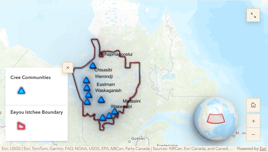 An interactive map showing the Eeyou Istchee territory and the location of the established Cree First Nations in Northern Québec. **Disclaimer: The Eeyou Istchee boundary is an approximate extent and shall not be interpreted as final or definitive.
Geographic information system (GIS) solutions bring land-based information into a single, shared view. For the CNG, digital maps make it easier to understand conditions across the territory and make informed decisions guided by Cree priorities and governance.
The Challenge: Making sense of information across distance
Delivering services across large, remote landscapes brings complex operational realities. Infrastructure teams, environmental staff and public safety staff work across long distances, often with limited time to gather the information they need. Leadership requires a clear understanding of what is happening across communities and departments.
After identifying these challenges, the CNG recognized the limits of disconnected maps, spreadsheets and reports. Information existed, yet it was not always shared in ways that reflected real work or decision-making. Leadership began looking for a way to bring land-based information together to inform both daily operations and strategic planning.
The Solution: A shared approach grounded in Cree values
The CNG developed a regional geospatial strategy using GIS technology to help communities see what is happening across Eeyou Istchee. At the 2025 Esri Canada User Conference, the CNG’s GIS program team shared how they are building a system that makes land and community needs easier to understand.
“GIS technology allows you to create maps to visualize areas of interest but also transform spatial data into meaningful statistics to communicate complex information clearly.”
~ Jonathan Elkhoury, Manager of the GIS program, Cree Nation Government.
The strategy brings together:
- Mapping of community assets and infrastructures with clear geographic context
- Sharing trusted information across departments
- Enabling planning for land use, services and stewardship
- Building internal capacity so knowledge remains within the Nation
CNG’s presentation described the development of a three-year geospatial strategy and road map that began in 2021. The work started with listening and engagement sessions across departments to understand how information was being used and where gaps existed. This process helped bring shared priorities into focus so geographic information could be organized, shared and used more consistently across the Nation.
“Now there are many users contributing to this big system. Non-GIS users are more and more visualizing information on dashboards and going out there to collect data on their phone. All of that is powered by GIS technology on the back end, but it’s made more accessible to the end user.”
~ Jonathan Elkhoury, Manager of the GIS program, Cree Nation Government
The Results: Better coordination, safer work, clearer decisions
CNG’s strategy is ongoing. Early outcomes show how shared location information reshapes coordination across a large territory.
- Greater visibility and easier access to land use and infrastructure information across remote regions
- Leadership conversations grounded in a common understanding of what is happening across the territory
- National recognition of Indigenous leadership in spatial planning, with selection from more than 600 applicants signaling broader value in Indigenous community-driven geospatial work.
Community members and mapping practitioners are seeing how trusted maps and data help with today’s planning and coordination. Over time, this shared information also supports cultural preservation, land negotiations and advocacy for resources.
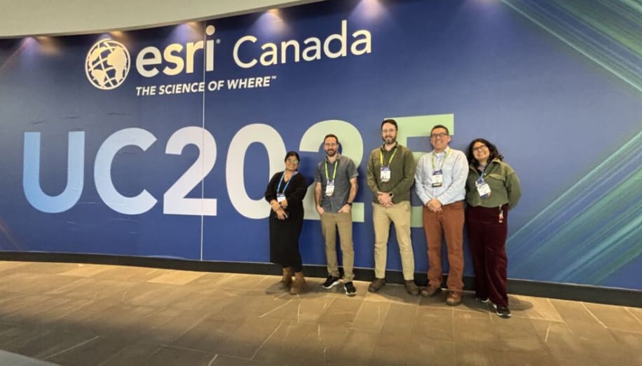 Cree Nation Government’s GIS program team proudly presented its regional geospatial strategy at the Esri Canada User Conference in Toronto on November 4, 2025. From L to R: Bindi S. Dave, Jonathan Elkhoury, Drew Hannen, Robert Shecapio and Abishiktha Charissa
The Benefits for communities today and tomorrow
Sharing location information helps communities build:
- Clear planning for infrastructure and services
When maps are easy to access, teams spend less time tracking down information and more time doing the work in front of them. - Shared understanding across departments
Maps and spatial tools help break down information silos so everyone, from infrastructure planners to field crews, works with the same trusted view of the territory. - Internal skills development and continuity
Developing GIS capabilities internally enhances local skills, capacity and creates pathways for community members to shape how their territory is managed and understood. - Long-term stewardship grounded in language and place
Trusted geographical insight assists decisions about infrastructure care, emergency response and land stewardship in ways that reflect community priorities and culture.
“We’re working on an electronic basemap that will have the Cree names, for people used to using online basemaps such as Google Maps.”
~ John Bishop, Toponymist, Social and Cultural Development Department, Cree Nation Government
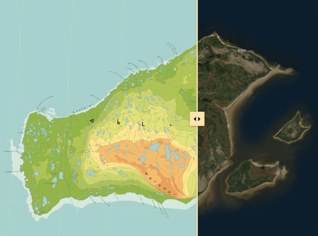
An example of a Cree Language Place Name map shared in CNG's ArcGIS StoryMaps story, The Cree Nation Government Geospatial Strategy. The ArcGIS Swipe tool helps viewers see how place names align across different map layers.
Curious about mapping in your community?
If CNG’s experience resonates with your community’s field work and operational goals, there are three ways to explore more:
- Learn how mapping is being used in Indigenous communities
Visit: Esri Canada Indigenous Communities Resources - Experience this story in an interactive way
Explore the CNG's StoryMaps story, Cree Nation Government Geospatial Strategy - Get practical tools and lessons from coast to coast to coast
Download the free field operations e-book, Lead with location, at esri.ca/field-ops-e-book to see how maps and location information can help your community manage resources, increase capacity and make decisions that support future generations.
Practical examples in this e-book show how communities are improving daily operations and planning for years to come. We hope their stories inspire ideas for your own community’s journey forward.
New to geographic information system (GIS) technology?
Find out What is GIS?
Let’s hear your story
Would you like to highlight your achievements and real-world impact with Indigenous communities? Share your community’s GIS journey here: GIS Success Stories
Learn how Indigenous communities strengthen stewardship and community planning with GIS at esri.ca/indigenous
Esri Canada has a rich history of close partnership with Indigenous peoples, communities and organizations in Canada, fostering meaningful relationships in support of reconciliation and self-determination. We blend traditional knowledge with GIS solutions to foster deep connections to the land that empower and enable future generations.
Learn more at esri.ca/indigenous
Resources
The Cree Nation Government Geospatial Strategy, CNG ArcGIS StoryMaps story, April 9, 2026.
Territorial Ambitions – Cree Nation’s GIS mapping highlighted at industry conference, The Nation Magazine, January 26, 2026.