ArcGIS Adventures: Inspiration in Action!
Showcasing ArcGIS work in the K-12 community can get educators thinking about what new projects they can integrate into their teaching. Summer is a great time to explore possibilities for the new school year! This post highlights work from elementary, secondary, and faculty of education classrooms in the past school year that focus on great tools, sustainability, current events and Indigenous history. We hope this will lead you to try something new with ArcGIS.
Sharing work can have a profound impact on educators across the country. There are times when educators are considering a project but are not sure how to go about doing it. Hearing about how others have done it can make the process clearer and easier to begin. Our network of educators using ArcGIS is a great base for us to learn from.
This school year, educators shared some incredible projects and activities that we want you to consider. Let’s have a look!
Explore this map to see where ArcGIS Adventures occurred this past school year!
ArcGIS Adventures
Starting on the Westcoast, there are a couple of educators that used ArcGIS StoryMaps to engage student learning and exploration.
Scott Alexander, Victoria, BC
Scott regularly uses StoryMaps as a core part of his curriculum because “they provide both academic rigor and an engaging way for students to demonstrate learning. He also values Esri Canada's strong support resources, which help students navigate complex projects successfully.”
The examples below highlight three StoryMap projects Scott did this year with his students:
- First Peoples in BC
In this project, students chose a First Nation in British Columbia and explored its history from pre-contact to the present. They used ArcGIS to showcase communities and places that many people may never visit. - Bowker Creek - focus on local geography
In the Bowker Creek restoration project, students used ArcGIS Online to investigate the importance of watershed stewardship. - Oak Bay – focus on local geography
In the final project for grade 12 geography, the students combined fieldwork, photography, mapping, and storytelling to explain the area’s unique geographic features. StoryMaps enables students to connect place, inquiry, and learning in meaningful ways.
Talia Ferris, Vancouver, BC
Talia was introduced to ArcGIS through her Bachelor of Education program at the University of British Columbia by geography educator Sean Nugent. Since then, she has primarily used StoryMaps, along with National Geographic MapMaker, to support geographic literacy and inquiry-based learning. Talia has plans to continue using ArcGIS when she is teaching full-time in the classroom. Explore the storymap she created about Women Warriers: The Samurai.
Moving on to Manitoba, a champion teacher and long-time user of ArcGIS, shares his work with us.
Rob Langston, Brandon, MB
Rob developed a project using StoryMaps, ArcGIS Online and ArcGIS analysis tools that challenged students to identify a suitable location for a new urban pond and forest using geographic analysis and environmental planning principles. The project gave students an opportunity to apply mapping, critical thinking, analysis, and land-use planning skills to a local challenge. Students connected environmental sustainability concepts with local geography and demonstrated how geographic inquiry can support community planning and decision-making.
This ArcGIS assignment Rob created is a great example of how you can use ArcGIS tools in your classroom.
Jumping to Eastern Canada, let’s have a look at work done in Ontario and Québec.
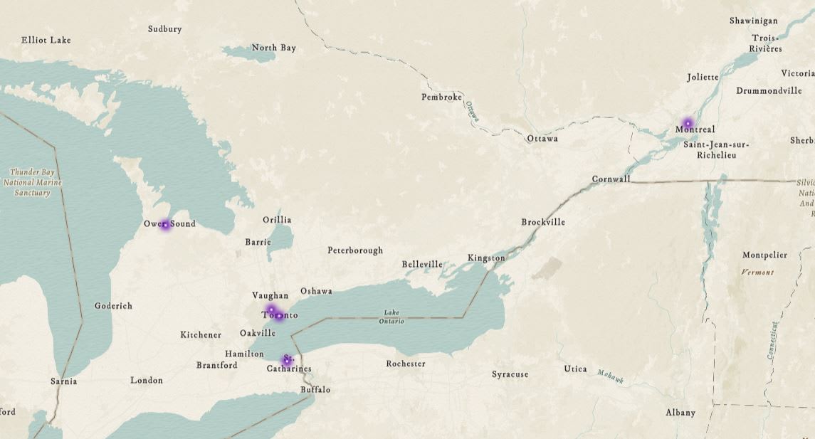 Explore the Eastern Canada locations that ArcGIS Adventures occurred this school year.
Ontario
Cory Munro, Owen Sound, Ontario
Cory, a longtime user of ArcGIS had his grade 9 geography students complete a project centered on a proposed residential development site near the local harbour in Owen Sound, Ontario. Students worked collaboratively in groups to design the space according to a specified set of criteria. They first developed their plans on paper and then transferred their designs into ArcGIS Online, created new feature layers and used points, lines, and polygons to represent different elements of their proposed communities.
Lotfi Djemai and Julien Lagarde, Ontario
French educators Lotfi and Julien from Conseil scolaire Viamonde, support GIS in K-12 by making it accessible and practical for teachers and students through board-wide access to ArcGIS, hands-on training, and ready-to-use learning modules. They integrate GIS into Grades 7-12 courses and certification programs, while promoting inquiry-based and project-based learning that builds students’ critical and problem-solving skills. You can read more about their work in this blog post.
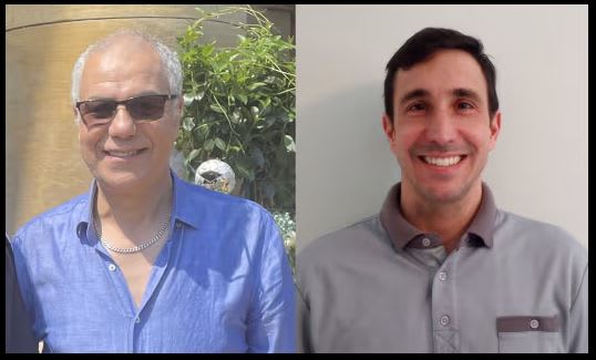
Lotfi Djemai and Julien Lagarde from Conseil scolaire Viamonde are passionate educators
supporting teachers in using ArcGIS in their classrooms.
Tony Cushman, Toronto, Ontario
Tony is an avid user of ArcGIS who created the Kindness Mappers project. This year, he designed a fun mapping challenge where his elementary class was tasked to find 51 beaver statues hiding around their school neighbourhood, each representing a team that is part of the global soccer tournament happening this year and recorded their findings on a shared map using ArcGIS Survey123.
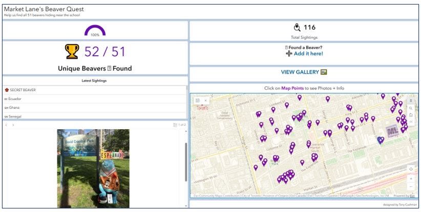 In In this mapping activity, students went outside to do something fun but also to learn about mapping and data collection. Note: The last entry (52) was added after the activity was completed.
Christine Kotesky and Lindsay Warner, St. Catharines, Ontario
Christine and Lindsay had their classes conduct a “Neighbourhood Liveability and Sustainability Audit.” This grade 9 geography activity was linked to the Liveable Communities unit. Students used Survey123, Map Viewer, and StoryMaps to investigate their school’s neighbourhood liveability using the geographic inquiry process. Through this assignment, they asked their own questions, collected data, analyzed information and shared their conclusions. The goal of this assignment was to get students to identify real examples of what makes a community liveable and sustainable.
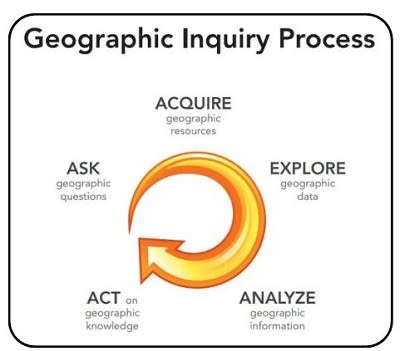 Students can use the Geographic Inquiry Process to explore issues in their community. Image from Esri.
Québec
Stéphanie Paquette, Montréal, Québec
Stéphanie Paquette uses GIS to make social studies more engaging and inquiry-driven by designing hands-on, project-based activities that connect directly to the curriculum. Her students collect and map data such as the origins of their clothing then analyze social, economic, and environmental impacts, encouraging critical thinking and global awareness. Through tools like ArcGIS Survey123 and StoryMaps, she helps students interpret geographic concepts in interactive ways while fostering discussion and reflection. Read more about Stéphanie’s work.
Are you a K-12 educator using ArcGIS?
Tell us what you have done by filling out a short survey, and we might highlight you in a future blog post. Learn more about GIS pathways for K-12 students by reading the Mapping Futures blog post.
New to ArcGIS?
K-12 educators in Canada can sign up today at k12.esri.ca. Begin your journey with the following resources:
Map it in Minutes
6X6 minute mapping activities for students using ArcGIS Online.
ArcCanada Atlas Activities
The ArcCanada Atlas is an interactive atlas that your students can use to uncover the hidden gems of this incredible country and explore other places in our world. Integrate these activities into your teaching next school year.
Happy Mapping!