Campus navigation for all at the University of British Columbia
You’ve arrived on one of the largest university campuses in Canada, but you don’t know how to get to your target destination, so you access the University of British Columbia’s online campus map. Not only does it build a path that takes you around active construction and accounts for the rolling landscape, but it also gives you the option of using keyboard navigation, a screen reader and wheelchair-appropriate routing, among other features. Built by UBC’s Campus + Community Planning with accessibility at its core, the map allows users to select the best route for them, whether they’re on foot, on a bike or using a wheelchair—a feature set that’s improving campus navigation for everyone.
Key takeaways
- The University of British Columbia (UBC), one of Canada’s largest universities, held community consultations that led them to build a campus wayfinding system that centres around accessibility.
- Now, when determining how to get from one location to another on either the Vancouver or Okanagan campus, users of all abilities can use this campus mapping system—built with ArcGIS, FME and an Oracle enterprise geodatabase—to get accurate directions that account for slope, active construction, the accessibility of each entrance and more.
- In this case study, discover how UBC’s Campus + Community Planning, in partnership with UBC’s Centre for Accessibility, built this system.
The University of British Columbia (UBC) is one of Canada’s largest and most research-intensive universities, with two major campuses in Vancouver and the Okanagan. UBC serves a diverse community of students, staff, faculty, residents, visitors and prospective students across extensive indoor and outdoor environments, including complex pedestrian, cycling and accessible routes.
Rachel Wiersma, manager of GIS and Data Systems in UBC’s Campus + Community Planning (C+CP), manages authoritative data for both campuses; GIS analyst Tom Lavery provides programming and development services; GIS systems analyst Jeff Burton in UBC Information Technology (IT) manages the GIS servers, enterprises databases and portals. Together, they provide GIS services, including wayfinding information, to both the University’s campuses.
“The Vancouver campus has a citylike feel with its 30,000 residents living on 400 hectares,” says Rachel. “Also, with its approximately 80,000 students, faculty and staff, getting from one side of campus to the other in all sorts of weather conditions can be difficult. The Okanagan campus is much smaller, with a population of about 14,000, but the hilly nature of the campus poses other challenges. Our job is to provide GIS services for building vibrant, connected and sustainable campuses.”
What problems was UBC’s GIS team facing with their campus wayfinding solution?
UBC’s original, award-winning wayfinding website—built in 2003 and last updated in 2016—was outdated, difficult to maintain and increasingly risky to operate. It suffered from broken links, obsolete content, missing new buildings, a non-mobile-friendly interface and security exposure from aging code. The maintenance model was unsustainable: building footprint maps and accessibility notes originated in CorelDraw and were later updated in Adobe Illustrator—an onerous workflow, especially given that the website covered around 200 academic buildings.
Despite these issues, UBC’s legacy wayfinding site was widely used because it offered detailed building footprint maps with accessibility information. However, the approach simply didn’t scale to evolving campus realities or modern expectations for responsive, mobile-first and assistive-technology-ready experiences. The gaps disproportionately affected users with disabilities (whether students, staff or visitors) who need reliable, current information to navigate safely and efficiently.
The Okanagan campus was an exception in one respect: it had a simple ArcGIS-based map. However, this map wasn’t equipped to reflect the campus’s steep topography, a central accessibility concern.
On top of these issues, consultations held in collaboration with UBC’s Centre for Accessibility surfaced an important nuance: that a person’s role changes their needs.
“Staff and faculty have different needs from students,” says Rachel. “A student may easily be able to get to a seat in a lecture hall, but for a professor to get into position to teach, they may need to use a completely different entrance depending on their accessibility needs.”
People coming to campus for the first time would be in particular need of good wayfinding, so the solution would need to be easy to use for them, too.
In 2016, UBC’s GIS data was being collected in a siloed, piecemeal and inconsistent manner. Over the following three years, the university undertook a campus-wide Geospatial Data Governance Initiative, resulting in the development of a standardized geospatial data model and a centralized authoritative data source accessible through a geospatial data service. This work established the foundation required to convert the data from the static maps on the original website into high-quality, integrated GIS data.
With this foundation in place, UBC then needed a unified, sustainable platform for both campuses that would account for a wide range of accessibility needs, and that would allow for easier, more frequent updates.
How did the UBC GIS team develop their new wayfinding solution?
Rachel and her team were positioned to rebuild the University’s wayfinding platform starting in 2022, with funding from the Centre for Accessibility in partnership with C+CP.
As a first step in the process, the team began by identifying user requirements. Guided by a disability justice approach—and the disability community motto “Nothing for us without us”—they ran a structured engagement process with the Centre for Accessibility, students, staff, faculty and external experts representing a range of access needs.
The feedback they received emphasized the importance of accurate entrances, slope awareness, accessible parking, audio directions and GPS coordinates, screen reader and keyboard navigation, and a way to report problems—plus the need to avoid routing pitfalls like sending users to loading docks or stair-only routes.
Commercially available mapping apps do a great job of getting everyone to campus, so the team narrowed the focus of UBC’s navigation tool to benefit pedestrians, cyclists and wheelchair users whose needs are unique to UBC campus, rather than centring drivers. Also, as it’s possible to navigate to or around most buildings using multiple routes, UBC's team looked for solutions to simplify that complexity, concentrating on first-time users to a building (e.g., those accessing said buildings on the first day of class, or entering a building for the first time to take a final exam).
Having seen a glimmer of potential in the form of the previous Okanagan campus map, the team elected to use ArcGIS as one core component of their campus wayfinding system.
A campus navigation system with accessibility at the core
Together, Rachel’s team built a modern, accessible wayfinding experience (Vancouver campus | Okanagan campus) that improves navigation for everyone—from cane users to wheelchair users to families with strollers.
How it’s built
Grounded in authoritative GIS data and automation, UBC’s updated wayfinding system integrates ArcGIS technologies with FME by Safe Software. The system’s components break down as follows:
- ArcGIS Enterprise (supplied by Oracle Spatial/Oracle Geodatabase): System of record for authoritative geospatial data.
- FME / FME Server: Validates and transforms data; automates updates back into Oracle and publishes to ArcGIS Server (via REST) and ArcGIS Online.
- ArcGIS Server: Hosts the Network Analysis Service for routing.
- Portal for ArcGIS and ArcGIS Online: Split operational model—Portal hosts the network analyst services; ArcGIS Online hosts construction polygons, basemaps and points of interest for broad access and performance.
- ArcGIS Maps SDK for JavaScript: Front-end web application delivering a responsive, accessible user experience.
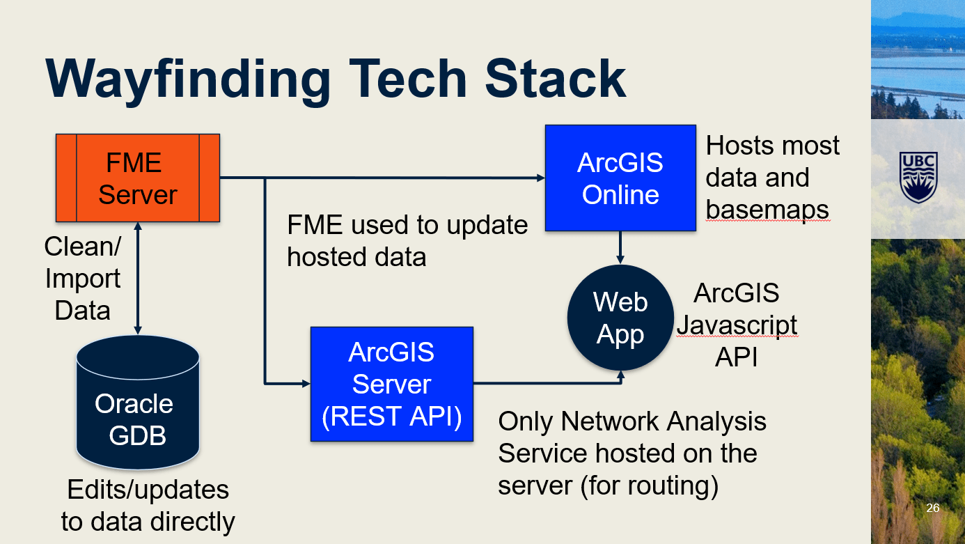
A slide from Rachel Wiersma and Tom Lavery’s presentation titled “University Campus Navigation for All: Wayfinding at UBC”, showcasing the different technology components of UBC’s campus wayfinding system. ArcGIS, Oracle and FME components work together to deliver the mapping and routing output that end users will interact with.
Accessibility-forward routing logic
The system supports multiple modes of transportation—walking, accessible travel and cycling—and allows map viewers to include or exclude certain features from the map they see. For example, the pedestrian view of the map excludes general roads except service lanes, whereas the accessible view excludes stairs, accounts for slopes and considers powered doors into each building.
Slopes are especially critical at UBC Okanagan, and so the solution routes users with slope in mind using data derived from LiDAR.
The system’s routing logic also accounts for construction closures. When temporary closures block entrances or segments, the system reroutes accordingly, enabling wheelchair users and others to plan ahead.
Data lifecycle and governance baked in
The UBC campus wayfinding system receives a constant stream of authoritative data that is continuously maintained and validated through FME. Frequent updates ensure that the system is always being fed high-quality, current information—especially important for users of the system’s accessibility features.
A better campus navigation experience for all
Ultimately, UBC’s wayfinding application (Vancouver | Okanagan) provides a campus navigation experience that feels designed with, not just for, the people who use it:
- Assistive-tech friendly: Users asked for GPS coordinates and audio-friendly directions, and the front end was built with compatibility for screen readers and keyboard navigation in mind.
- Complex spaces handled gracefully: Areas like the Nest, UBC Vancouver’s student hub, can be crowded and confusing. UBC’s campus wayfinding system provides clean wayfinding with appropriate indoor/outdoor transitions.
- Better navigation for everyone: The Centre for Accessibility reports frequent use and positive feedback, and features like step-free routing have proven valuable for community members—e.g., for key buildings where the accessible entrance is actually at the back of a building or for parents using stroller-friendly paths during special events.
Since launching the updated wayfinding sites—for UBC Vancouver in 2023 and for UBC Okanagan in 2024—the university has observed strong adoption:
- ~5,000 daily users at peak periods (September and January)
- 90,000+ routes generated since September 2023, 2,300+ of them accessible
- 210,000+ unique users across 400,000+ sessions
Now, more people than ever are able to easily make use of UBC’s wayfinding information and get around both campuses in ways that are well suited to their needs. And it’s a great foundation for projects to come next, including indoor wayfinding and other indoor GIS applications that are on the UBC GIS team’s radar.
“Considering that better accessibility improves life for everyone, not just people with disabilities, this story needs to be heard by more campus-based ArcGIS users across the country,” says Rachel. “We will keep building on creative solutions to enhance campus accessibility.”
Looking to learn more about using geographic information systems (GIS) for campus planning and wayfinding? Discover how to digitally transform campus operations with ArcGIS. Or, explore licensing options if you’re interested in GIS for facilities management, planning, accessibility analysis, routing, campus safety or asset mapping.