Bridging GIS and BIM: The technical path to integration
Connect spatial context with design precision. In this post, explore how GIS-BIM integration helps AEC teams work smarter, cut delays and deliver more resilient, data-driven projects.
Overview
The integration of geographic information system (GIS) technology and building information modeling (BIM) has become a key focus for the Architecture, Engineering and Construction (AEC) industry. While GIS provides the spatial context necessary for large-scale planning, BIM delivers detailed 3D models essential for design and construction. Bringing these two technologies together allows for a more comprehensive and intelligent approach to project management. While the technical barriers to seamless GIS-BIM integration can be challenging, they can be overcome with the right solutions, offering valuable opportunities for innovation and growth.
This post explores how AEC professionals can successfully integrate Autodesk and Esri solutions, the challenges faced and best practices for a smooth and efficient adoption process.
The need for GIS-BIM integration
AEC projects require both geospatial awareness and precise design details. Historically, GIS and BIM have existed in separate silos, limiting collaboration, creating data redundancies and making it difficult to align projects with their environmental and regulatory contexts.
By integrating these systems, organizations can unlock several key benefits:
1. Enhanced decision-making
AEC professionals can gain a comprehensive view of project environments by incorporating both spatial and design data. GIS provides a macro-level understanding of factors like terrain, land use, environmental impact and transportation networks, while BIM delivers the micro-level details of a specific building or infrastructure component. A key shared benefit of this integration is enhanced clash detection, which allows for the identification and resolution of design conflicts early in the process, ensuring smoother project execution and reducing costly errors.
For example, urban planning projects that incorporate GIS data on existing utilities, zoning regulations and flood risk can be better aligned with BIM models to avoid costly modifications during construction. Engineers can analyze how a new structure will fit into the broader city infrastructure, ensuring that it integrates seamlessly into transportation, water management and emergency response systems.
2. Improved workflow efficiency
Traditional AEC workflows often involve significant duplication of effort, with teams manually transferring data between GIS and BIM platforms. This can lead to inconsistencies, data loss and inefficiencies.
With seamless integration, site planners, civil engineers and architects can collaborate within a common data environment, working with shared datasets that combine spatial and design data. This reduces redundancies and ensures that updates in one system are automatically reflected in the other. For example, when an environmental engineer updates floodplain boundaries in a GIS dataset, BIM designers can instantly incorporate this data into their models, allowing them to adjust foundation designs accordingly.
3. Optimized asset management
GIS and BIM are not just useful during the planning and construction phases; they are equally critical for long-term asset management. When GIS is linked to BIM models, asset managers can track the lifecycle of infrastructure in a spatial context.
For example, a city managing bridges and highways can use GIS, integrated with IoT sensors, to monitor real-time traffic patterns and environmental conditions. Meanwhile, BIM models provide detailed maintenance histories of individual structures. By combining both systems, facility managers can proactively schedule repairs based on live data, reducing downtime and enhancing the longevity of infrastructure.
4. Enabling smart cities and infrastructure
As cities and governments embrace digital transformation, GIS-BIM integration is at the heart of smart infrastructure projects. Smart cities rely on connected data sources to manage resources efficiently, optimize transportation networks and improve public services.
By linking BIM models of buildings, roads and public spaces with GIS data, decision-makers can simulate different urban planning scenarios, improve energy use and enhance sustainability efforts. This enables proactive infrastructure planning that reduces environmental impact and enhances resilience to climate change.
Challenges in GIS-BIM integration
Despite its clear benefits, integrating GIS-BIM presents several technical and operational challenges.
1. Data incompatibility
One of the biggest hurdles in GIS-BIM integration is that GIS and BIM use fundamentally different data structures. GIS operates in geospatial coordinate systems and manages large-scale geographic datasets, while BIM uses detailed 3D object-based models with precise design specifications.
To bridge this gap, industry professionals must use interoperable formats like Industry Foundation Classes (IFC), CityGML or openBIM standards, which provide a common data format for the exchange between systems.
2. Lack of standardized workflows
Many organizations struggle with GIS-BIM integration due to the absence of clear methodologies and standardized processes. Without defined workflows and templates, integration efforts can be inconsistent, leading to fragmented data and misaligned project phases.
To overcome this, firms should develop best practices for data management, find clear use cases for integration and establish a team of GIS-BIM specialists to promote and support collaboration.
3. Legacy systems and data silos
Many AEC firms rely on legacy IT systems that are not designed for modern GIS-BIM integration. These outdated systems may lack APIs, cloud connectivity or the computing power needed to process complex datasets.
A phased migration to cloud-based GIS-BIM platforms can help organizations modernize their workflows while ensuring backward compatibility with older datasets.
4. Lack of government standards for public sector work
A significant challenge is the absence of government-mandated standards for GIS-BIM integration in public sector projects. Without clear regulations or standards, public sector organizations often face inconsistencies in data quality, format and integration practices. This lack of oversight can lead to inefficiencies and hinder the full potential of GIS-BIM integration.
To address this, industry stakeholders can advocate for the adoption of international standards, such as ISO 19650, which focuses on information management for BIM, alongside other relevant GIS standards.
Esri and Autodesk: A connected ecosystem
Recognizing these challenges, Esri and Autodesk have developed a suite of integration solutions to bridge the gap between GIS and BIM.
1. ArcGIS GeoBIM
A web-based application that seamlessly connects the Esri ArcGIS system with the Autodesk Platform, including Autodesk Construction Cloud, enabling project teams to visualize GIS data alongside BIM models in a geospatial context. This integration enhances coordination between design and construction teams, helping to reduce project delays and minimize rework.
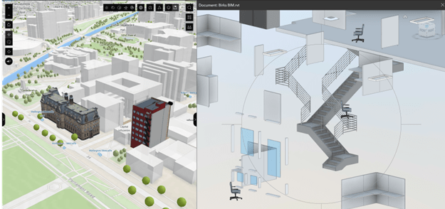
ArcGIS GeoBIM – A screenshot showcasing GIS and BIM data side by side in a real-world project.
2. ArcGIS for AutoCAD
A plugin that provides access to GIS data directly within AutoCAD, allowing designers to overlay spatial datasets on CAD drawings without leaving the Autodesk environment.
3. Data interoperability workflows
By using industry-standard formats like IFC and CityGML, as well as Esri’s API tools, organizations can automate data exchange between GIS and BIM platforms, reducing manual processing time.
Best practices for successful GIS-BIM integration
To successfully integrate GIS and BIM, AEC firms should follow these key strategies:
- Adopt open standards – Use interoperable formats and APIs to ensure seamless data exchange between GIS and BIM platforms.
- Develop standardized workflows – Establish best practices for GIS-BIM integration, ensuring consistency across projects.
- Leverage cloud-based solutions – Utilize platforms like ArcGIS GeoBIM to enable real-time collaboration and remote accessibility.
- Start with pilot projects – Test GIS-BIM integration on smaller projects before scaling across the organization.
Conclusion
The integration of GIS and BIM is no longer just a theoretical possibility—it’s a critical necessity for modern AEC workflows. By leveraging solutions like ArcGIS GeoBIM, ArcGIS for AutoCAD and open data standards, organizations can eliminate data silos, improve collaboration and significantly enhance project outcomes.
This integration reduces the need for ETL (extract, transform, load) processes, eliminating manual data duplication and ensuring that all teams work with the most current, accurate information. As a result, firms can save valuable time and resources, leading to faster project delivery and reduced errors.
With GIS and BIM technologies rapidly evolving, their convergence is quickly becoming an industry standard rather than an optional enhancement. Firms that invest in GIS-BIM integration now will benefit from improved efficiency, innovation and sustainability, giving them a competitive edge in the built environment.
In the next post, we’ll explore the executive value of GIS adoption and how organizations can measure return on investment (ROI), making a strong business case for GIS integration in AEC and Environmental sectors.
Stay tuned!
Questions? Contact us at esri.ca/aec
Explore real-world success stories and discover how Esri Canada can support your projects today: resources.esri.ca/aec
Don’t miss the first blog in this series:
Embracing GIS in AEC: The key to industry-wide digital transformation
In our first post, we explored how the AEC industry is embracing GIS and the benefits of integrating geospatial intelligence into projects.