9 common ArcGIS Survey123 errors and how to troubleshoot them
Have you encountered errors in ArcGIS Survey123 before and have no idea where to start in tackling them? Well, in this blog post, I’ll show you how to interpret and solve errors like a pro in ArcGIS Survey123 Connect.-
Did you recently get an error in ArcGIS Survey123 and do not know where to start troubleshooting? Don’t worry, we’ve got you covered! This blog post will go over nine common ArcGIS Survey123 errors and how to fix them. You’ll be tackling errors like a tech support pro in no time.
The different types of errors
Let’s look at the common errors users encounter when using ArcGIS Survey123.
Note: This blog post covers errors you might encounter in ArcGIS Survey123 Connect, not the web designer.
There are three main types of errors:
- Saving errors
- Publishing errors
- Send errors
1) Saving errors
Saving errors occur when attempting to save a survey in ArcGIS Survey123 Connect. These are generally caused by improper use of the .xlsx sheet when creating the survey.
Example save error
2) Publishing errors
Publishing errors occur when you try to publish the survey. They will either not let you publish or cause the software to fail to publish your survey.
Example publishing error
3) Submission errors/send errors
Submission errors occur when submitting or sending a survey. For example, if a user downloads and submits a survey entry, they will receive an error message (in red) or a warning (in gold).

Example sending error from the ArcGIS Survey123 field app
![Screenshot of a survey error in ArcGIS Survey123. The top of the screen displays a red dialogue box. The box has text stating: “Failed to submit.” Below this is a dark red box with the following text: “[{“id”:0”addResults”:[{“objectId”:-1”uniqueID”:-1,”GlobalID”:”{89FA472A-0091-4429-82D1-77371348802}”,”success”:false,”error”:{“code”:1000,”description”:”String or binary data would be truncated.\r\nThe statement has been terminated.”}}]}]](https://res.cloudinary.com/uf-528100/image/upload/v1727889116/Example_save_error_2_nkbe8w.png)
Example error from an ArcGIS Survey123 web submission
Example warning from an ArcGIS Survey123 web submission
Common errors and how to solve them
In this section I will show you nine common errors, three for each different type of error. I’ll discuss their causes and how to fix them.
Save errors
-
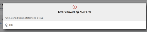
Error: Unmatched begin statement: group.
-
Error: Something broke the parser (dependency cycle amongst the Xpath expressions: related question).
-
Error: There has been a problem trying to replace ${field} with the Xpath to the survey element named ‘field’. There is no survey element by this name.
Publishing errors
-
Error: Unmatched begin statement: group.
-
Error: Something broke the parser (dependency cycle amongst the Xpath expressions: related question).
-
Error: There has been a problem trying to replace ${field} with the Xpath to the survey element named ‘field’. There is no survey element by this name.
Submission/send errors
-
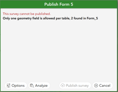
Error: Only one geometry field is allowed per table, 2 found in Survey_Name.
-
Error: Warning: This survey has already been published. The existing feature service is not compatible with the survey.
-
Error: The custom feature service submission_url is not compatible with this survey.
Common save errors
Error: Unmatched begin statement: group.
Cause: This error is caused when you open a group or repeat statement in ArcGIS Survey123 but don’t close it, or vice versa.
Solution: To include a group in your survey, you must have both a begin group/end group enclosing your questions. Otherwise, these need to be deleted to successfully resolve the error. Same applies to repeat portions.
Error: Something broke the parser (dependency cycle amongst the Xpath expressions: related question).
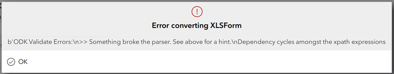
Cause: This error is caused when a calculation loops back on itself. A question with a calculation cannot include itself in the calculation. For example, if your question is called “square”, you can’t put that in a calculation on the “square” question as it will endlessly loop the calculation.
Solution: Scroll through the error by hovering over it to identify where the error is occurring in the survey. Then, delete the problematic calculation and place it in a hidden field. This way, you can still achieve the desired result without breaking the survey.
Error: There has been a problem trying to replace ${field} with the XPath to the survey element named ‘field’. There is no survey element by this name.
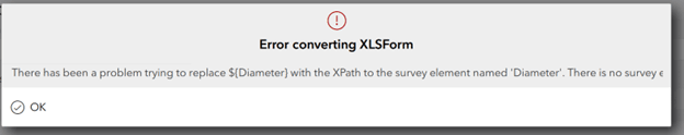
Cause: This error is caused by not having the suggested field name/question in your survey. This generally happens because when you add dynamic values to the calculation field. These are case-sensitive, which makes it easier to get them wrong.
Solution: Scroll through the error by hovering over it to identify where the error is occurring in the survey. Then change the calculation to the proper name of the field with the proper casing.
Common publishing errors
Error: Only one geometry field is allowed per table, 2 found in Survey_Name.
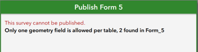
Cause: This error is caused by having two geometry questions in a survey at the same time. For example, both a geopoint and a geotrace question.
Solution: Delete the extra geometry question by right-clicking on the row it’s associated with and pressing delete. If you would like the user to input multiple points into a survey, use a repeat question instead.
Error: Warning: This survey has already been published. The existing feature service is not compatible with the survey.
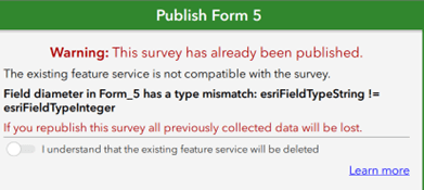
Cause: This error occurs when you attempt to republish a survey after changing the question type of an already published question.
Note: This error does not prevent you from publishing, but it will delete all current records and produce a new feature service with a different URL/ID.
Solution: When republishing a survey, make sure that all fields are the same type as in the previous upload. If you overwrite your local file, you can restart the editing process by redownloading the survey. Additionally, if you do not need to transfer attachments, you can copy the current records from the existing feature service and append them to the new feature service.
Error: The custom feature service submission_url is not compatible with this survey.
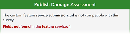
Cause: This error occurs when the submission URL for the feature service is not the same as the survey, making it incompatible with the survey.
Solution: Make sure the submission URL in your survey is pointing to the correct hosted feature layer in your ArcGIS Online or ArcGIS Enterprise organization account and that it has all the same fields in the survey.
Common submission errors
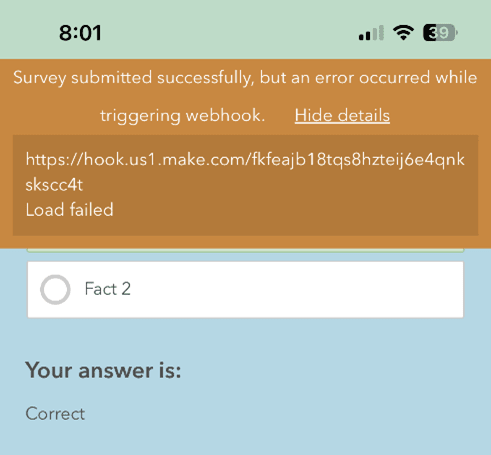
Error: Survey submitted successfully, but an error occurred while triggering webhook.
Cause: This error indicates that a webhook attached to your survey did not trigger correctly. The cause could be anything from the webhook being disabled or insufficient credits in your webhook account.
Solution: Delete the webhook if it is not needed or fix it if you plan to continue using it.
Note: If this warning appears, the survey will still be submitted and recorded in ArcGIS Survey123, but the webhook will not run.
Error: String or binary data would be truncated. This statement has been terminated.
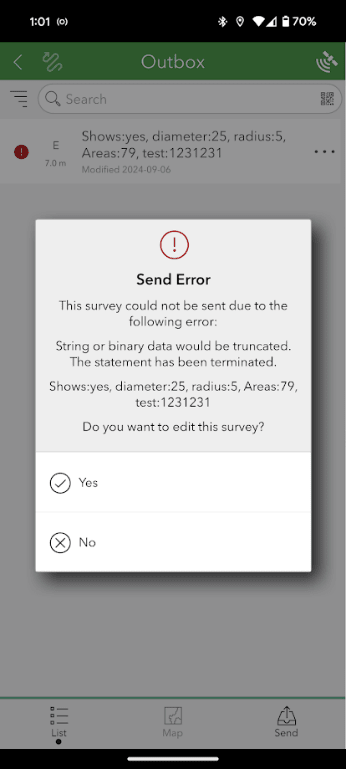
Cause: This error occurs when a select_one or select_multiple question exceeds the characters available in the field length. For example, a select_one answer that exceeds the default limit of 255 characters.
Solution: Adjust the possible survey answers to meet the 255-character limit. If you need more than 255 characters, you can increase the character limit for a survey field by specifying a greater field length in the bind::esri:fieldLength column for that field/question.
Error: Error connecting to ArcGIS Online. Error code:3 host not found. 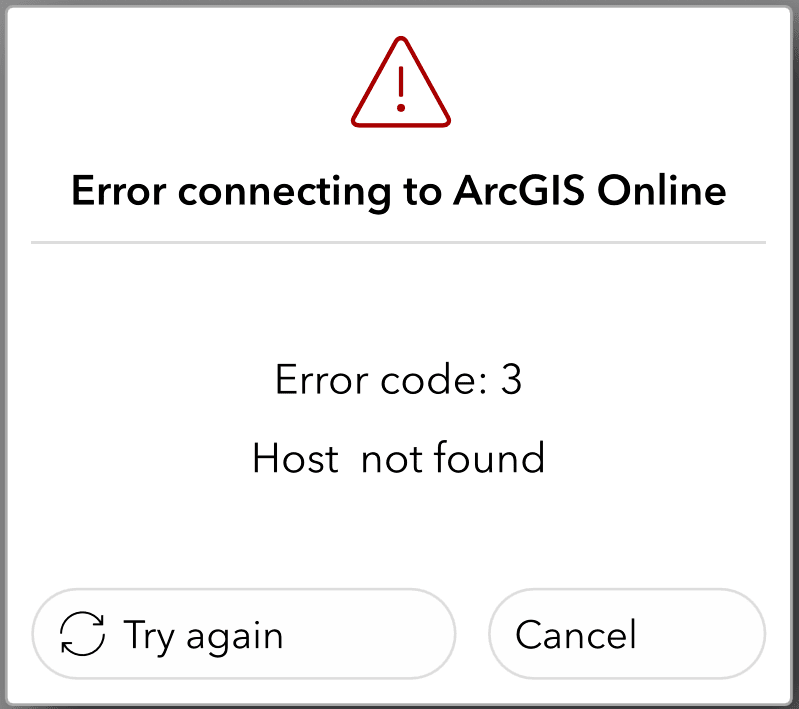
Cause: This error occurs when there is an insufficient connection to send the survey—for example, when connected to a wi-fi source without an internet connection to send the entry (example: printer wi-fi).
Solution: Run an internet speed test to ensure you have a recommended minimum upload speed of 5 Mbps on your current connection. If not, connect to a faster/stronger connection point and resend the survey. If you need to use your survey offline, look here for more information.
How to troubleshoot errors on your own
What if your error isn’t listed above? In this section, we will explore how to view and interpret errors, as well as how to use ArcGIS Survey123 Connect’s built-in troubleshooting tools to gain a better understanding of errors.
Interpreting an error
Most errors provide the line number or question name where the issue occurs in the survey file, helping you locate the problem for effective troubleshooting. It’s a good idea to search for these errors on the Esri Community to see if other users have encountered them. Often, users have faced similar issues and found solutions.
Analyzing a survey for errors
Before publishing or republishing a survey in ArcGIS Survey123 Connect, you can analyze it for errors or readability problems. Just click on the Analyze button on the publish dialogue box and ArcGIS Survey123 will notify you about any potential errors with your survey.
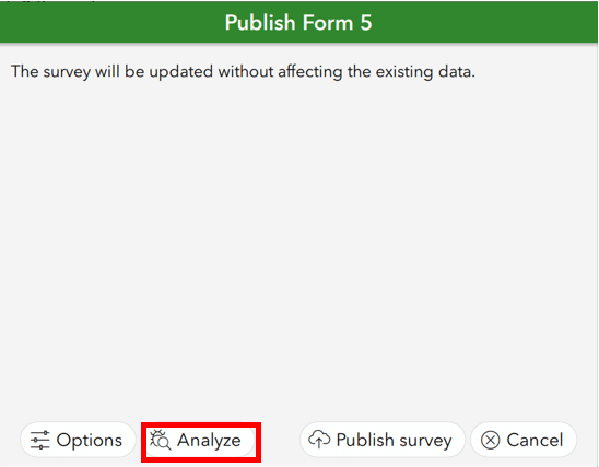
Click on “Analyze”
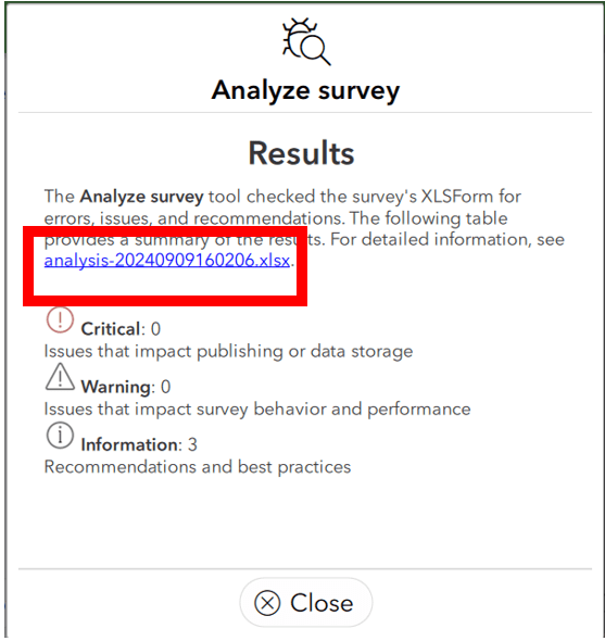
In this dialogue box, ArcGIS Survey123 will inform you of critical errors, warnings and information problems.
-
Critical errors are urgent and should always be resolved before moving forward.
-
Warnings may cause problems, depending on your survey, so it’s advisable to review them.
-
Information problems/recommendations are best practice recommendations for your survey.
-
For example, adding a survey title.
-
More detailed information is provided in the Excel error report attached to the analysis.
Click on the error report
When using the Analyze survey tool report, problems like the “string would be truncated” error can be found before the survey is published. You can also access direct documentation links to learn more about any errors and easily resolve them.

Example error report record
Final thoughts
When creating a survey in ArcGIS Survey123 Connect, errors can be frustrating, especially if you’re unsure where to start. However, with the information in this blog post, you can tackle these errors with confidence. Understanding why the errors occur will help you address them effectively, reducing the need to contact tech support. However, if this blog did not resolve your error, please contact us at Esri Canada Technical Support or your local distributor.
Do not live in terror and fear an error! You now have the skills to be an ArcGIS Survey123 Connect error repairer.