On the Map with Earth Rangers: Finding the Caribou
Earth Rangers fosters youth engagement through interactive, hands-on activities. Their integration of ArcGIS into the Finding the Caribou activity deepens connections to science, Indigenous-based learning, social studies, and environmental stewardship making it an inspiring way to honour Earth Day and empower young people to protect the natural world.
Esri Canada’s K-12 Education group is excited to collaborate with partners across Canada who use ArcGIS to help youth develop geographic literacy, spatial awareness, critical thinking, and analytical skills. One such partner is Earth Rangers - a charity that transforms children’s concerns about the environment into positive action with a mission to create a new generation of conservationists.
In the development of the Finding the Caribou activity, we worked closely with Stephanie Doyle, the Director of Education at Earth Rangers. She is a passionate and experienced leader in environmental education who created an impactful, student-centred resource. We are very proud to have her as a partner in education and to share her vision of the activity.
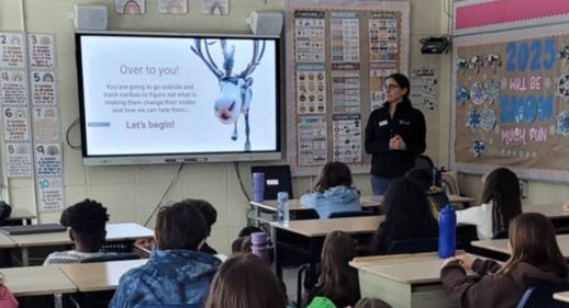
Stephanie getting grade 5 students ready to head outside and start the Finding the Caribou activity.
Finding the Caribou
The Earth Rangers Finding the Caribou activity, designed for grade 5 and 6 classes, immerses students in Canada’s Northern region through outdoor learning that deepens their understanding of biodiversity and conservation science no matter where they live. The learning goals include:
- Develop new perspectives (Indigenous and Western) on conservation and the role of technology, like ArcGIS in research
- Assess the impacts of human activity and climate change on Arctic biodiversity and Northern communities
- Create a local conservation action plan
- Inspire interest in studies and careers in the natural sciences
Learning steps
The activity introduces students to how animal tracking and mapping support real conservation decisions, based on a real-world example from the Vuntut Gwitchin First Nation community of Old Crow in Northern Yukon. Students first learn about the Porcupine Caribou, a barren-ground herd that migrates more than 2,400-km each year, making it the longest land migration of any mammal on Earth. Then they head outdoors to take on the role of either a caribou or a tracker, bringing the learning to life through movement and observation.
In the first round, the “caribou” leave coloured hoof print markers (tracks) around the schoolyard. Using an ArcGIS Survey123 created survey on a mobile device, they log their location and answer migration-related questions each time they stop to leave a track. Questions explore topics such as locating food sources, safe resting areas for caribou, and the impacts of wildfires on lichen. To answer them, students use resources that draw on both Indigenous and Western perspectives to build an understanding of the effects of climate change on Arctic biodiversity and its direct impact on Northern communities.
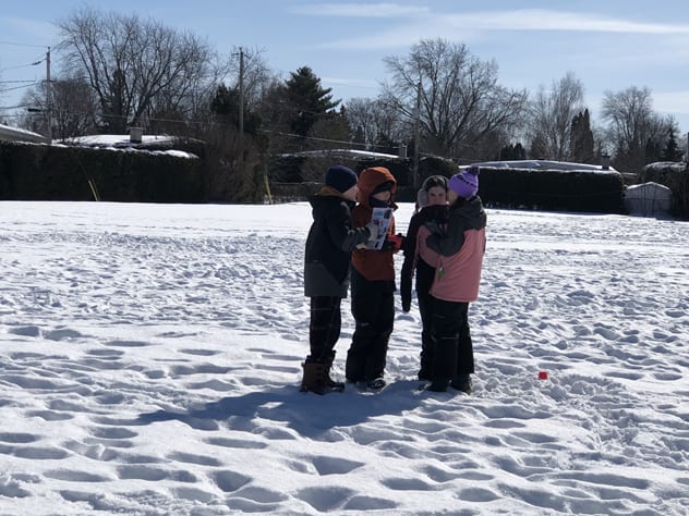
A group of Grade 6 students working together to answer a question on the Survey 123 App.
In the next round, the “trackers” head out to follow the hoof prints in sequence, also using the survey to respond to questions and map their route. While one group is leaving or following tracks, the other group is working on a complementary activity to deepen learning about changes in Arctic ecosystems.
In the final step of the activity, students apply their learning by creating an action plan to support conservation in their own community.
Interested in bringing the activity to your classroom?
Book a session to discover how Find the Caribou can fit into your classroom and you will receive a free kit to get started.
Why ArcGIS was used for this activity
ArcGIS is a geographic information system (GIS) platform that provides users the ability to create maps, surveys and apps, conduct analysis, tell a story, collect data and much more.
Stephanie wanted to offer students first-hand experience with the same type of technology that scientists use, and to understand how animal tracking supports conservation research. At the same time, it was important to choose a learning tool that is available to educators at no cost and easy to use, ensuring the experience is accessible for all.
ArcGIS is a valuable tool for teaching and learning
Students are excited to use “real” tools, just like scientists in the field. These ArcGIS tools can be used to study different topics and are used in a wide range of sectors by professionals globally.
In the Finding the Caribou activity, they explore the web maps in ArcGIS that include the survey data they collect in the field collaboratively. This helps them visualize how their class used the space and allows them to see other schools that participated in the activity.
Coming up in 2026
A French version of this activity will be available soon. We look forward to sharing the resource with educators!
Stephanie extends her sincere thanks to Natural Sciences and Engineering Research Council of Canada (NSERC) and the Weston Family Foundation, as well as researcher Karl-Antoine Hogue for their support in developing this activity.
“We are always looking for new collaborations and creative ways to support teachers and students with engaging activities that integrate technology.”
She also recognizes the Education and Research Team at Esri Canada and expresses her gratitude.
“This activity would not have come to life without their generous support. They dedicated time and expertise to developing innovative solutions to ensure students have the best learning experience possible. Thank you!”
Resources for Earth Day
Earth Rangers - Spring Quest
A fun way to make a difference for wildlife right where you learn and play!
Mapping the Future: How GIS Tackles Climate Change
Learn how GIS empowers us to understand, mitigate and adapt to climate change.
Protecting our Ecosystems
Explore ArcGIS content that covers biodiversity, sustainability and conservation in Canada.
New to ArcGIS?
K-12 educators in Canada can sign up today at k12.esri.ca. Begin your journey with the following resources:
Map it in Minutes
6X6 minute mapping activities for students using ArcGIS Online.
ArcCanada Atlas Activities
The ArcCanada Atlas is an interactive atlas that your students can use to uncover the hidden gems of this incredible country and explore other places in our world. Integrate these activities into your teaching this school year.