Getting Technical – September 2024
What are the benefits of adopting named users? How do you make an imagery basemap POP with embossed streets and borders? Where can you access the new low-code/no-code app builders developer guide? How do you participate in the 2024 ArcGIS StoryMaps competition? What's new in ArcGIS Earth Mobile 2.2? How do you improve the accessibility of your dashboard? How do you time-enable a layer in ArcGIS Online? Get answers to all these questions and more in this month’s edition of Getting Technical.
Features
Action Required: ArcGIS Online SAML Customers
ArcGIS Online's SAML signing and encryption certificate expired on September 24, 2024. It is necessary to take action to ensure that your organization can continue to use your Enterprise Identity Provider (IDP). This certificate is required when an organization has enabled signed requests or encrypted assertions. Find out how to enable your IDP.
Embracing User Types: Unlocking the Benefits of Adopting Named Users
This blog post covers the best ways to navigate the newly available user types.
ArcGIS for Microsoft 365: FAQ
Answers to the frequently asked questions about the ArcGIS for Microsoft 365 products
Stop, collaborate, and listen: getting the most out of collaboration in ArcGIS
Collaboration enables ArcGIS Online and ArcGIS Enterp organizations to share content with one another - read on for the details.
Enter the 2024 ArcGIS StoryMaps Competition to Build a Better World Together
Use your unique talents — from cartography and data analysis to photography and design — to tell your story with ArcGIS StoryMaps. Then submit it to the 2024 ArcGIS StoryMaps Competition: Storytelling for a better world.
More ArcGIS Users Now Have Access to Imagery Hosting and Analysis in ArcGIS Online
Creator user types and higher can host imagery, and Professional user types and higher can perform image analysis—without needing any additional extensions.
Prepare for the September 2024 release of ArcGIS Navigator: Rebuilding Locators in MMPKs
The September 2024 release of ArcGIS Navigator brings significant performance enhancements and bug fixes. For organizations that use custom Mobile Map Packages (MMPKs) it may be necessary to rebuild the Locator and MMPK to maintain optimal performance when searching for addresses and assets. This article guides you through the necessary steps to ensure a smooth upgrade.
Zoning Mapping Best Practices
Dive into our brief blog post and our linked ArcGIS StoryMap for some seamless zoning mapping and bylaw strategies ensuring less friction and enabling better and faster decisions for sustainable development.
Discover A New Way to Geocode Large Files
Esri is excited to introduce an innovative new solution: a Batch Geocode service.
Leverage the Unique Capabilities of BA Mobile App
Read about the on-the-go capabilities of BA Mobile App, which make it a useful companion to ArcGIS Business Analyst Web App.
Design Service Areas with Living Atlas and the Build Balanced Zones Tool
This blog post walks through a simple workflow designing areas in the state of Virginia to serve the veteran population.
Guide to the File Geodatabase API
This blog covers the ins and outs of the File Geodatabase API.
Demographic Data Enrichment in ArcGIS for Power BI
You can use ArcGIS for Power BI to add detailed data-driven map visualizations with spatial analysis to your Microsoft Power BI reports with demographic data enrichment.
Get Creative with Image Choreography Using Media Layers
This post covers the seemingly endless creative opportunities for image choreography in visual storytelling.
Introducing the New Low-code/no-code App Builders Guide for Developers
We recently released the new Low-code/no-code app builders developer guide. The new guide helps developers use ArcGIS app builders so that they can create web apps by writing little to no code. This article provides an overview of the guide including key topics to help you build web apps with the four main app builders: ArcGIS Instant Apps, ArcGIS Dashboards, ArcGIS StoryMaps and ArcGIS Experience Builder.
Introducing the New Portal and Data Services Guide for Developers
We have recently released the new Portal and data services developer guide. The guide is designed to help developers use tools and build geospatial applications. This article provides an overview of what you can expect to find in the guide including key developer topics to help you build applications with the portal tools, portal service, and data services.
Simplifying ArcGIS Utility Network Migrations
A new tutorial has been released that demonstrates how to use these simpler tools and models: Load data into the ArcGIS Utility Network.
Bridging the Gap Between your IFC Files and ArcGIS Indoors
BIM (Building Information Modeling) provides tools for planning, design, and construction of buildings. After project completion, organizations can also operationalize the digital models created with BIM to inform facility maintenance and operation. BIM enables the visualization of buildings in true-to-life 3D space. The ArcGIS ecosystem has powerful GIS and BIM integration tools that enable AEC and facilities management professionals to understand how their built environment fits into the physical environment and how separate construction projects interact with each other.
Gain Insights about your Constituents with the Elections and Voting Overview Infographic Template in Business Analyst
Business Analyst infographics are helpful tools for understanding the demographics, behaviors, and priorities of people living in a specific location. Decision makers can learn about their constituents by running an infographic, such as Community Summary, to capture a snapshot of an area.
Make an Imagery Basemap POP with Embossed Streets and Borders
The World Imagery Basemap is a lovely resource spanning the Earth in all directions at all scales. If you want to add a level of context you can always add a reference overlay. But what about baking a reference overlay into the imagery in a way that makes it look, like, sort of 3D?! Is it even possible? Should we try it? Are we allowed to? Let’s try it in ArcGIS Online…
Living Atlas Data at Your Fingertips in ArcGIS Pro
ArcGIS Pro users enjoy ready-to-use data at their fingertips!
Use Business Analyst's Target Marketing Wizard to find Customers in a New Area
In this article, we will demonstrate how to leverage your existing customer data to identify the population segments most likely to utilize your services and pinpoint where to find new customers within these segments.
Edit Schema Reports for Conversion
The launch of the Convert Schema Report geoprocessing tool in ArcGIS Pro 3.3 changed the way you can share, design, and modify geodatabase schemas. Managing schemas can be a daunting task, but with this new tool, you can design a schema that suits your needs.
What's New in ArcGIS Earth Mobile 2.2 (September 2024)
The latest ArcGIS Earth mobile release enhances how users interact with geospatial content. The improvements help boost field operations, create more efficient workflows, and increase understanding of GIS data. Key highlights from this release include offline support for raster data types, legend support, optimized colors for symbology, and the ability to search and filter 3D Tiles, in addition to managing KML sub-layers.
What's New in ArcGIS Image Dedicated (August 2024)
The post covers the key highlights and enhancements of the August 2024 release of ArcGIS Image Dedicated.
More ArcGIS Users Now Have Access to Imagery Hosting and Analysis in ArcGIS Online
Whether you’re using imagery to provide context through visualization or conducting analyses ranging from simple hillshade calculations to complex feature extraction and suitability assessments, ArcGIS Online offers the ideal solution. This SaaS-based platform allows you to host, manage, analyze, and visualize your imagery seamlessly, without the hassle of deploying and maintaining on-premises infrastructure.
Display "Quantity by Category" Symbology in ArcGIS Pro
When symbolizing a point feature layer in ArcMap, you have the option to use “Quantity by category” symbology. This multivariate symbology option is a combination of unique values and graduated symbology – for each unique value present in the field (typically a text field), you can display its symbol with a range of colors or sizes using a numeric field.
Improving the Accessibility of your Dashboard
In this blog, we’ll share what you as a dashboard author can do today to make your dashboard more accessible to a wider audience. These new features and capabilities were introduced with the June 2024 ArcGIS Online update and will be available in the ArcGIS Enterprise 11.4 release.
GeoSnaps: Viewshed Analysis Tool in ArcGIS Online’s Map Viewer
Check out this GeoSnap to see how this zero-credit analysis tool is a simple solution for viewshed analyses! It uses Esri’s World Elevation Services in the background, requiring only a point Feature Class as input data.
FAQ: How to Time-Enable a Layer in ArcGIS Online
To learn how to enable time on a layer through the layer’s item page, watch the short video or follow the steps outlined in this Esri Community post.
Hot Tip: Use Response Caching as a Shortcut for Servers
Response caching is a backend server mechanism that stores the results of a query so that when the same query is made again, the server can quickly provide the stored answer instead of processing the request again.
View all product specific blogs on the ArcGIS Blog site.
Announcements
What's new in ArcGIS StoryMaps (August 2024)
What's New in ArcGIS Monitor 2024.0
View more announcements in the ArcGIS Blog | My Esri on Esri Community
Service Packs, Patches & Product Support Updates
Get the Most from the Support Site with the Esri Support AI Chatbot
The Esri Support AI Chatbot is now live on support.esri.com. Use it to get answers to your questions and discover fixes for issues.
Impact of Google Chrome and Microsoft Edge 127 updates on ArcGIS Enterprise
An update to Google Chrome and Microsoft Edge in July 2024 that negatively impacts and breaks key parts of the ArcGIS Enterprise portal experience for versions prior to ArcGIS Enterprise 11.3.
Esri released a series of patches, beginning in June 2024, to resolve this issue. All ArcGIS Enterprise deployments whose users interact with the ArcGIS Enterprise portal and ArcGIS Enterprise-based web applications in ArcGIS Enterprise 11.2 or earlier, using Google Chrome or Microsoft Edge, must install these patches to avoid service interruptions.
Deprecation FAQ: ArcGIS Developer Subscriptions
ArcGIS Developer Subscriptions at the Essentials, Builder, Professional, Premium, and Enterprise plan levels have been deprecated. This is part of an effort to streamline and simplify our developer offerings. Read the FAQ to learn about the new ArcGIS Developer Bundle.
Deprecation Notice: ArcGIS StreetMap Premium Attributes
If you use the StreetMap Premium streets.gdb or mapping.gdb directly in your internal processes or workflows, there are some upcoming changes that you should be aware of.
ArcGIS Configurable Apps Roadmap for Retirement
ArcGIS Configurable Apps is reaching its retirement, and we are eager to provide you with a clear understanding of the timelines and specifics involved. At the point of retirement, you will no longer be able to create new configurable apps. In addition, apps built using Configurable Apps will no longer be accessible, so we strongly encourage you to begin the process of migrating them to ArcGIS Instant Apps. This transition not only ensures access to new capabilities within ArcGIS Instant Apps but also keeps you aligned with the latest enhancements in Esri web mapping and geospatial web applications. Read the full article to find the outlined timelines and essential details.
Deprecation Notice for ArcGIS Community Analyst: Transition to ArcGIS Business Analyst Web App
ArcGIS Community Analyst is being deprecated entirely. The final release of Community Analyst will be in October 2024. Community Analyst will remain accessible to users until their next annual renewal date after December 1, 2024.
Portal for ArcGIS Security 2024 Update 1 released
The Portal for ArcGIS Security 2024 Update 1 is available. Install these patches at your earliest opportunity to address these vulnerabilities.
Announcement: Deprecation of ArcGIS Field Maps on Windows Subsystem for Android
ArcGIS Field Maps was released on Windows 11 via the Windows Subsystem for Android in 2023. Microsoft is retiring the Windows Subsystem for Android on March 5, 2025, and the Amazon App Store will no longer be available on Windows 11 starting March 6, 2024. ArcGIS Field Maps on Windows 11 via the Windows Subsystem for Android will be retired on March 5, 2025.
Announcement: Deprecation of ArcGIS GeoPlanner
ArcGIS GeoPlanner, an extension for ArcGIS Enterprise and ArcGIS Online, is being deprecated. Read the blog for more details.
Announcing the Deprecation of ArcGIS Maps SDK for Java
The ArcGIS Maps SDK for Java is being deprecated, with its final release scheduled for November 2024 in the form of Version 200.6.
Deprecation notice: ArcGIS Collector on Windows platform to retire
ArcGIS Collector on Windows platform to retire; replaced by Field Maps on Windows 11 WSA.
Deprecation of ArcGIS Workflow Manager (Classic)
The final release of ArcGIS Workflow Manager (Classic) is scheduled for Q4 2024, at the release of ArcGIS Pro 3.4/ArcGIS Enterprise 11.4.
ArcGIS AppStudio Retirement Roadmap and Beyond
AppStudio 5.5 will be a “Long-Term Support” (LTS) release of the product and the last major release of AppStudio. The ArcGIS AppStudio product will be officially retired in February 2025.
ArcGIS Web AppBuilder Roadmap for Retirement
ArcGIS Web App Builder is retiring, and we want to share the retirement timelines and details with you. While your ArcGIS Web AppBuilder apps that you have built will continue to work, Esri’s recommended path for taking advantage of new capabilities in ArcGIS as well as for staying abreast of the changes in browser technology is to migrate applications to ArcGIS Experience Builder. Read the article for the timelines and details.
Important Notice for ArcMap Users with Subscription Licenses
If you are using ArcMap today as part of production workflows and have an ArcGIS Desktop subscription license, there is some important information in this blog for you to consider.
ArcMap entered Mature support on March 1, 2024
ArcMap has entered the Mature Support phase of its product life cycle on March 1, 2024, marking the end of software updates and patches. Now is the ideal time to transition to ArcGIS Pro if you haven't already made the move. We have curated several resources here to help guide your migration journey.
ArcGIS 10.8.2 is the current release of ArcMap and will continue to be supported until March 1, 2026, as established in the ArcGIS Desktop Product Life Cycle. This was a maintenance release only and does not include new functionality. This update does not extend the ArcGIS 10.8.x product life cycle. Esri does not have plans to release an ArcMap 10.9. The ArcMap Continued Support page, will be able to answer your questions regarding continued support of ArcMap as well as contains resources to help you transition your work moving forward into several Esri products such as ArcGIS Pro.
ArcGIS Field Maps 24.2.1 release
A focused patch release to the iOS and Android mobile apps, 24.2.1 has some strategic bug fixes and enhancements for mobile users.
Deprecation Notice for ArcGIS Community Analyst: Transition to ArcGIS Business Analyst Web App
ArcGIS Community Analyst is being deprecated entirely, including ArcGIS Community Analyst’s inclusion in ArcGIS Hub Premium subscriptions. For ArcGIS Hub customers, please view the ArcGIS Hub Premium subscription section.
Reminder: ArcGIS Collector on Windows platform to retire
On Oct 1, 2024, ArcGIS Collector on Windows will be officially retired and no longer supported by Esri.
Web Watch – Blogs, Podcasts and Useful Resources
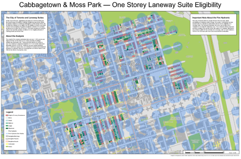
Map of the Month: Cabbagetown & Moss Park – One-Storey Laneway Suite Eligibility
This map constitutes an analysis of all parcels in the Toronto neighbourhoods of Cabbagetown and Moss Park to determine eligibility for the construction of a one-storey ancillary building containing a laneway suite. The analysis was conducted using the spatial conditions set out in the City of Toronto’s laneway suite by-law along with data provided by Open Data Toronto.
This map was originally published in the 2021 Map Calendar.
Spatial Report Podcast Season 1 | Episode 18: Mapping the Climate
We’re going to pumpkin spice up your GIS in this episode of the podcast. First, we’ll look at how our user community is using GIS to better understand and confront climate change. Then our ArcGIS Pro GeoGeek will share what’s new in ArcGIS Spatial Analyst.
Don’t miss an episode. Get a quarterly roundup of resources sent right to your inbox by visiting our Communication Preference Centre and selecting “Getting Technical” under Esri Canada Blog Digests.
View more articles in ArcUser | ArcNews | ArcWatch
Training
Location Analytics Using ArcGIS Insights
Build skills to quickly identify data patterns and relationships using drag-and-drop functionality, powerful analysis tools and interactive maps, charts and tables. This course provides a solid grounding in ArcGIS Insights capabilities and components. Learn how to structure an analysis and dynamically visualize and analyze nonspatial and spatial data together, then share your work using attractive visual themes and repeatable analysis workflow models. Course concepts apply to all ArcGIS Insights deployment options. Attendees will use Insights desktop in course exercises.
Esri Canada Seminars & Webinars
Technology for Inclusion: Accessibility Across the ArcGIS System
Sep 26, 2024
Maps help users discover our world but only if they can be understood by all who read them. There should be no barriers to what you achieve with Esri software. This webinar will define accessibility in ArcGIS, provide examples of inclusive design and highlight recent innovations in creating accessible GIS applications.
Neighbourhood Planning with ArcGIS Urban
Oct 17, 2024
ArcGIS Urban is designed to empower planners to explore how planning initiatives can foster urban growth. This webinar will take you through the lifecycle of a plan in ArcGIS Urban, focusing on how the software can be used to address planning challenges around affordable housing and inclusionary zoning.
Ask Me Anything: Everything You Need to Know About NG9-1-1 & GIS
Oct 22, 2024
Join our AMA-style webinar to engage with Esri Canada’s NG9-1-1 GIS experts. Get all your GIS questions answered, from specific data to general insights on transitioning to NG9-1-1 GIS. Address the challenge of understanding and implementing NG9-1-1 GIS requirements effectively.
Anticipating the Biggest Changes in the Future for the Property Assessment Industry
Oct 23, 2024
With technological advancements and evolving stakeholder expectations, the assessment industry is transforming. Attend this webinar for insights on how you can anticipate and embrace these significant changes to prepare yourself for the future.
A GIS App for Every Need: Choosing the Right App in the ArcGIS Web Ecosystem
Oct 24, 2024
Whether you're a seasoned GIS professional or a newcomer to the field, this webinar will guide you through the diverse landscape of ArcGIS web applications. Don't miss this opportunity to enhance your GIS toolkit and learn how to make confident choices when selecting apps in the ArcGIS web ecosystem.