Get more from your investment in geo with a GIS workforce assessment: pt. 2
GIS tools and data management maturity will only get you so far. To leverage organization-wide location intelligence, your workforce needs to be structured, managed and trained. In this conclusion to his two-part blog post series, Esri Canada management consultant Darren Sutton describes how to conduct a gap analysis on your GIS workforce, then create a plan to fill those gaps.
Key takeaways
· Once you’ve finished describing the current state of your GIS workforce, conduct a gap analysis by comparing the current and future state descriptions you created in part 1 of this two-part blog post series. Identify gaps, using plain language and diagrams to describe what’s missing.
· Then, perform a GIS skill and competency assessment by looking at five skill categories that build on one another. From most foundational to most specific: non-technical skills and competencies; cross-industry GIS and IT skills and competencies; Esri product skills; GIS skills for industry-specific applications; and GIS leadership skills. Determine targets for each skill using a three-to-five-point scale, then score your existing workforce’s proficiency. This way, you’ll easily be able to create a skill uplift plan when it comes time.
· Once your gap analysis is complete, develop a workforce development plan with concise recommendations, as well as a skill uplift plan that identifies priority areas.
· Finally, turn your plans into a sequence of activities to start addressing gaps.
Welcome back!
In part 1 of this blog post series, I took you through how to describe the current state of your geographic information system (GIS) workforce to make it easier to determine where you stand. Now that you’ve completed that part of the assessment, you’re ready to proceed to the next step: the gap analysis.
Take up the current and future state descriptions you created in part 1. Compare the two, paying attention to the key elements defined in my previous post (organizational context, roles, processes and skills & capabilities). What are the notable differences between states? These represent gaps in your GIS workforce that you’ll need to fill to attain your organization’s GIS objectives. While every organization is different, asking yourself the following questions can help you identify the kinds of gaps you may encounter.
|
Organization |
|
| Role definitions |
|
| Effectiveness of processes |
|
| Skills and training |
|
Look for gaps falling within these categories, then cast your view wider. Describe the gaps you observe with a broad audience in mind. Your gap analysis will certainly be of interest to staff with a background and interest in GIS, but you will also need to gain support from those who know very little about it. Use plain language, avoid technical terms and be as descriptive as possible. To articulate an organizational problem, don’t assume that your reader follows your logic: show it to them!
Diagrams can be very helpful in this context. Consider using a high-level diagram of your organization that includes major departments. Then, add on major GIS uses and highlight the gaps and why they are significant to the organization. Process diagrams are also helpful to highlight inefficiencies or bottlenecks. Compare “as is” and “should be” process diagrams and highlight the major gaps. These diagrams are not just analytically useful, they are effective ways to show the gaps in your organization.
Evaluating GIS skills and competencies
A gap analysis is valuable by itself and can form the basis of a powerful GIS workforce enhancement plan. However, I highly recommend you take a deeper look by performing a GIS skill and competency assessment. The breadth and depth of skills that an organization now needs to maximize its location intelligence has outpaced training programs, role requirements and competency matrices alike. The odds overwhelmingly are that your organization could do with uplifts to its GIS skillsets. But first, you need to know what skills to target.
At Esri Canada, we divide GIS skills and competencies into five categories. Naturally, every organization has different priorities, and the skills and competencies that are evaluated should be chosen accordingly. Broadly speaking, the following five categories serve as a useful guide to help identify the full range of GIS skills and competencies.
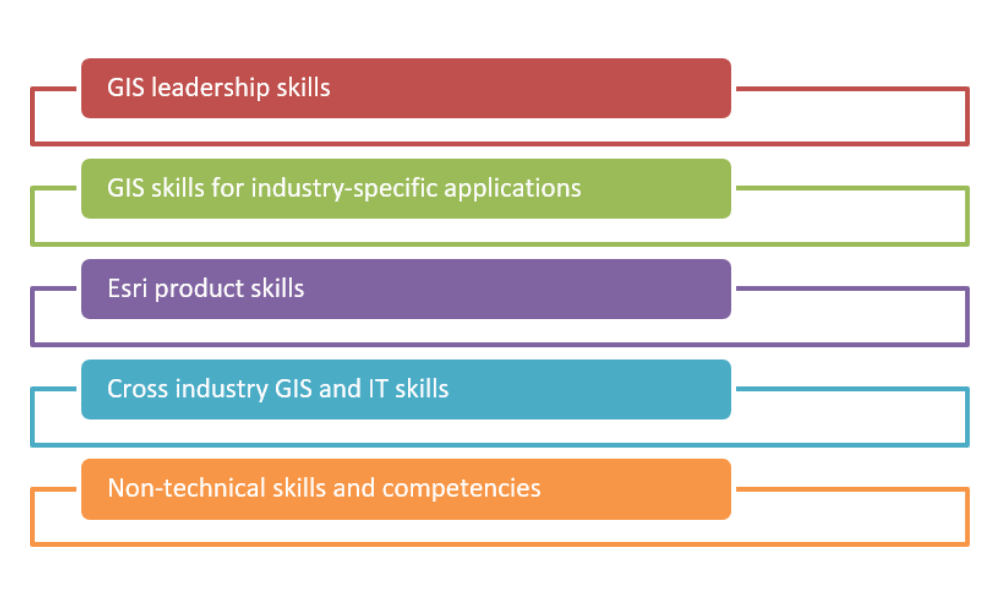
As the stacked structure above implies, these skills build upon one another. In fact, a candidate’s readiness for promotion or job enlargement may be based on their proficiency with skills in each progressive category. To elaborate on specific skills, consider the following sample descriptions.
| Category | Sample skills and competencies |
| GIS leadership | Leadership skills that apply in particular to GIS include project management, service level management and risk management. |
| Industry-specific | GIS skills applicable to specific industries, such as land management, network topology or permitting. |
| Esri products | Esri’s product set includes ArcGIS Online, various ArcGIS applications (such as ArcGIS Survey123) and development tools such as ArcGIS Notebooks. |
| Cross-industry GIS and IT | Broadly applicable GIS competencies include cartography, spatial data management, remote sensing and LiDAR. |
| Non-technical | Foundational skills such as writing, communication and problem solving. |
To evaluate your organization’s GIS skillsets, prepare a list of skills and competencies falling into the five categories identified above. You will want to determine targets for these skills and competencies for each GIS role I discussed in part 1 of this blog post series. Your target score indicates how proficient you want each role, on average, to be within your organization. This doesn’t need to be a very precise exercise. For instance, you can use a simple three-to-five-point scale where points represent a range from beginner to expert.
Next, score your workforce’s proficiency in each skill or competency. You can do this in different ways. You might ask your staff to do self-assessments and collect the results. Or, you could do guided assessments with a sample of staff or ask managers for their input. Try to gather as many sample assessments as you can so that individual results don’t bias your evaluation. Try also to get coverage from as many departments as possible so that you can offer targeted recommendations.
Finally, compare the scores you gathered with your targets. This will lead to a list of skills and competencies that you will prioritize for uplift. Remember that different roles are likely to have different priorities, so you should include a breakdown by role in your analysis. You may also find it useful to compare average scores for different departments. Some department staff may score lower simply because they don’t have access to GIS training resources!
Finally, define a skill uplift plan that targets the high priorities you have identified for each GIS role. Each plan can include a mix of resources and approaches, depending on the skill and role. Here are some options you can consider.
| Method | Description |
| Facilitated training | In-person or virtual training courses with defined lessons, materials and evaluations. |
| Self-directed learning | Virtual training resources, books, blog posts and other resources by which learners manage their own knowledge acquisition. |
| Knowledge sharing | An opportunity for staff to learn from one another. For example, experienced GIS users might give some of their time to share their learnings and experience with more junior users. |
| Coaching | A coaching relationship pairs a less experienced staff member with a more experienced one for a defined period of time. Coaches provide ongoing support and guidance to a more junior GIS user as they grow in their role or prepare for a new one. |
Example
Esri Canada recently worked with a regional municipality that wanted to evaluate its current GIS skills and competencies and form a plan to keep pace with changing industry standards and evolving technologies. We worked with their GIS leaders to determine five GIS roles, then develop a matrix of skills and competencies with target scores. We then conducted a survey of staff to gather self-evaluations. We collected our results in a scored skill matrix that identified priority gaps and built a skill uplift plan for the regional municipality to help them address the gaps.
Forming a plan
Having identified workforce gaps and done a skill and competency assessment, your final step should be to collect your results into a plan. After seeing your findings, your colleagues are likely to ask: “okay, but how do we address this”? Your plan should answer this question. While the level of detail and format you include will depend on your organization and context, I recommend you cover three important elements.
1. Workforce development plan
Your workforce development plan will be based on your gap analysis. Develop concise recommendations to help fill the gaps. In many cases, your plan can include a set of options for each gap. Since each organization is unique, you can’t assume there are templated solutions available, but GIS workforce development often involves the following steps:
- Step 1: Reorganize the GIS workforce to fill service delivery gaps.
- Step 2: Introduce new positions to help fill gaps in processes or capabilities.
- Step 3: Transfer staff to place them in the optimal situation for their GIS skillsets.
This sequence ensures that changes to the workforce flow from the top down, which will help avoid confusion and misalignment during implementation.
2. Skill uplift plan
Your skill uplift plan should be based on your GIS skill and competency assessment, which features prioritized skill gaps and recommended methods for each GIS role. These should be sequenced into a plan that will progressively implement the needed uplifts. Skill uplift plans have to be adaptable to context, but the following guidelines can be useful:
- Introduce role-based training plans at the outset. Explain the sequence of training methods and the rationale behind selecting them.
- After launching, introduce coaching or knowledge-sharing opportunities. Your plan should include support for these important relationships.
- Include a mechanism for tracking the uptake of training and monitoring coaching and knowledge-sharing.
3. Putting it all together
Assemble your workforce and skill uplift plans into a schedule of activities. You don’t need to be very specific about the timeframe and duration. It’s more important to plan the sequence of activities. Spread your workforce and skill uplift activities out to avoid overwhelming people with concentrations of change.
In all of this, don’t forget that communication is essential when implementing any change. I recommend that your plan also include targeted messaging to establish the rationale for change, as well as opportunities for feedback from affected staff. This will help you address issues and concerns as they arise.
Note: Change management for GIS is a larger topic that you can read more about here.
We can help!
I hope you’ve found this blog post series informative and useful. If you’re ready for a GIS workforce assessment in your organization, Esri Canada’s Management Consulting team can help. We work with customers to assess their current workforce, identify gaps, do GIS skill and competency assessments, and develop plans to implement our recommendations. Contact us to learn more.