Find health GIS open data easily with the new Esri Canada Health GIS Hub
Here at Esri Canada, we recognize the need for accessible, authoritative data essential for public health and healthcare analytics that seamlessly integrates with geographic information systems (GIS). Enter the Esri Canada Health GIS Hub, a health-focused GIS open data site, entirely connected and compatible with Esri technology. In this blog post, we delve into the features of our new health community hub and how you can benefit from its offerings in your daily work.
Many of the health challenges we are faced with in Canada are inherently geographic: where are the hot spots of measles cases? Where are Canadians at risk of heat waves in the summer? Where should Canadians seek urgent care when their local emergency room is closed? In what neighourhoods should we expand mental health services? In effect, the use of georeferenced health data, GIS and location intelligence by Canada’s health community is growing.
Health information professionals, epidemiologists, policy analysts and health systems planners increasingly rely on spatial data to better understand communities in need to inform public health interventions at a hyper-local level, to connect patients to care and reduce health inequity.
Despite the existence of data on health outcomes, demographics and social determinants of health, and health facilities, access to good health data is often limited. Georeferenced health data is often stored on premises within a health institution or haven’t been georeferenced in the first place. And while there’s never been more health data openly available in Canada, it can be daunting to discern whether the data is up to date, authoritative or in a format capable of integration with your pre-existing internal data. These collective challenges limit health professionals from developing location intelligence— insight gained from visualizing and analyzing geospatial data—for public health programs or improved access to primary and acute care.
This is why we created the Esri Canada Health GIS Hub, a health-focused GIS open data site, entirely connected and compatible with Esri technology.
The power of geospatial information
GIS has long been a staple in urban planning, environmental monitoring and disaster response. But the potential of GIS stretches far beyond these areas. By adding health data into the mix, GIS becomes a powerful tool for understanding the spatial dimensions of health and healthcare, opening doors to new insights and strategies for disease prevention, resource allocation and improved patient outcomes.
A treasure trove of georeferenced health data and apps
The Esri Canada Health GIS Hub is a virtual platform that acts as a repository of geospatial data, a health GIS-related project platform and a health community geospatial resource site. Data holdings are curated, maintained and updated by a team of health GIS experts at Esri Canada. This site serves as a portal for complex georeferenced health data served via user-friendly visualizations offered by Esri software. Researchers, policymakers, healthcare professionals and the public now have access to a treasure trove of information and applications that can drive informed decision-making and cost-effective strategic planning.
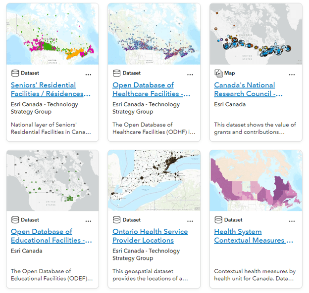
The Health Hub features dozens of curated health-GIS datasets and applications from across Canada.
Take advantage of these benefits
- Informed Decision-Making: Policymakers can make data-driven decisions about healthcare resource allocation, infrastructure development and public health campaigns.
- Targeted Interventions: By identifying specific geographic areas with higher disease risk, public health interventions can be tailored to address the needs of those communities effectively.
- Community Engagement: The open nature of the platform invites the health community— including the public—to engage with open georeferenced health data. This transparency can foster a greater understanding of health challenges and promote community involvement in finding solutions.
- Research Enhancement: Researchers can access a wealth of data without the need for time-consuming data collection, enabling them to focus on analysis and generating insights.
Explore these key features
- Data Portal: This site collates a wide range of data sources, from health administrative boundaries to public infrastructure and healthcare facility locations. This diversity of information allows users to explore the intersections between health and various social determinants.
- Interactive Maps: The heart of this platform lies in its interactive maps. Like all ArcGIS Online products, users can visualize health data overlaid on geographic maps, identifying clusters of diseases, healthcare deserts and patterns that might otherwise remain hidden in spreadsheets.
- Community Hub: Health is a team sport! Researchers and professionals with access to ArcGIS Online can collaborate on projects by sharing their own geospatial datasets and maps. This Hub fosters a collaborative approach to data-driven problem-solving and accelerates innovation.
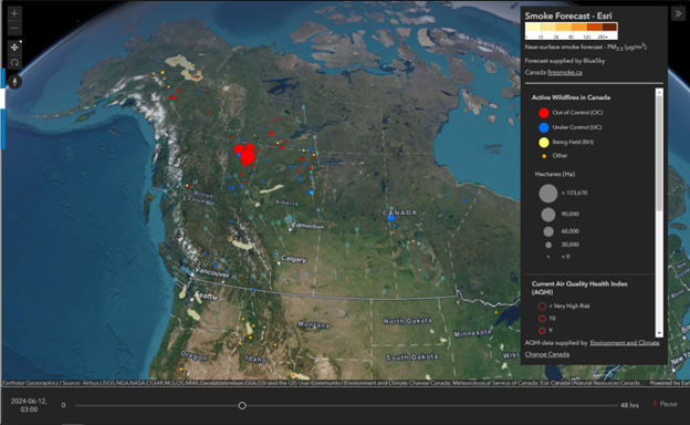
An animated 48hr smoke forecast in 3D, with current Air Quality Health Index (AQHI) from IoT sensors.
After years providing up-to-date, standardized and georeferenced COVID-19 data in the Esri Canada COVID Hub, the Health GIS Hub marks an exciting new milestone in Esri Canada’s dedication to supporting our health industry. As our public health and healthcare systems evolve into a tech-centric future, harnessing the power of GIS and health data will support more cost-effective interventions, healthier communities and a brighter future for all Canadians. We’re excited to be a part of this transformative change!
Visit the Esri Canada Health GIS Hub and let us know what you think by commenting below.