What’s new in the Living Atlas: Indigenous datasets
New Indigenous datasets just dropped in the Living Atlas! Explore and celebrate the power of Indigenous knowledge. Start your journey today.
In a world where data drives decisions, the importance of accurate and culturally relevant information cannot be overstated. As Indigenous communities across Canada strive for self-determination and the preservation of their rich cultural heritage, the role of curated Indigenous datasets becomes paramount. The Living Atlas, a comprehensive repository of geographical and cultural content, stands as a beacon of this effort, offering invaluable resources that empower Indigenous communities and foster a deeper understanding among all Canadians.
One of the standout features of the Living Atlas is the Indigenous Geographical Names dataset. This extensive collection includes nearly 30,000 official place names of Indigenous origin, reflecting the profound connection between Indigenous peoples and their lands. From the serene waters of lakes and rivers to the majestic peaks of mountains, these names encapsulate the essence of Indigenous worldviews and languages. Updated weekly, this dataset ensures that the evolving landscape of Indigenous nomenclature is accurately represented, honoring the traditions and histories of First Nations, Inuit and Métis communities.
Beyond geographical names, the Living Atlas encompasses a wide array of datasets that highlight the diverse aspects of Indigenous cultures and lifestyles. The Remote Communities Energy Database, for instance, sheds light on the energy needs and solutions in remote Indigenous communities, while the Tribal Council Locations dataset maps the locations of the many council hubs that play a crucial role in governance and community support. Additionally, datasets on Indigenous community infrastructure, mining agreements, and treaties provide a comprehensive view of the socio-economic and political landscape of Indigenous Canada.
Through these meticulously curated datasets, the Living Atlas not only preserves the rich tapestry of Indigenous cultures but also serves as a powerful tool for advocacy, education, and sustainable development. By supporting this initiative, donors, volunteers, and stakeholders can contribute to a future where Indigenous knowledge and perspectives are integral to the fabric of Canadian society.
Highlighted below are the Indigenous datasets included in the Living Atlas:
Indigenous Geographical Names in Canada
In Canada, close to 30,000 official place names are of Indigenous origin, and efforts are ongoing to restore traditional names to reflect Indigenous cultures. The Indigenous Geographical Names dataset includes the names of populated places and administrative areas, water features such as lakes, rivers and bays, and terrain features like mountains, capes and valleys. This dataset was extracted from the Canadian Geographical Names Database, Canada's authoritative national database of place names and contains over 60 Indigenous languages with origins in First Nations, Inuit and Métis world-views. As more Indigenous names in the Canadian Geographical Names Database are identified and as more Indigenous names are officially recognized and adopted, the dataset will continue to grow and is updated weekly to reflect any changes.
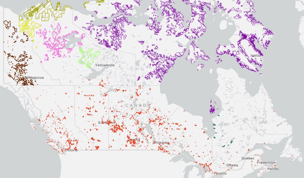
Indigenous Lands of Canada dataset
Indigenous Lands of Canada
The Indigenous Lands dataset depicts the administrative boundaries of lands where the title has been vested in specific Aboriginal Groups of Canada or were set aside for their exclusive benefit. The dataset includes but is not limited to; Indian Reserves, Cree-Naskapi Category 1A and 1A-N Lands, Yukon First Nation Settlement Lands, Kanesatake Mohawk Interim Land Base, the Inuit Owned Lands, Tlicho Lands, Inuvialuit Lands, Gwich’in Lands, and Sahtu Lands. The dataset is maintained monthly by the Surveyor General Branch (SGB).
First Nations Locations in Canada
The First Nations geographic location dataset contains the geographic location of each First Nation’s administrative office address as it is registered in the Indigenous Services Canada (ISC) Band Governance Management System (BGMS). This dataset is the official source of First Nation geographic locations for Crown-Indigenous Relations and Northern Affairs Canada (CIRNAC) and Indigenous Services Canada (ISC).
Tribal Council Locations in Canada
The tribal council geographic location dataset is the official source for Tribal Councils geographic map location for Indigenous Services Canada (ISC) and Crown-Indigenous Relations and Northern Affairs Canada (CIRNAC). Each tribal council point represents an address as it is registered in Indigenous and Northern Affairs Canada (INAC) Indian Government Support System (IGSS). A connection with the IGSS is in place to ensure that any update to the system is reflected in the attributes data associated with the geography of each tribal council.
Remote Communities Energy Database
The Remote Communities Energy Database is the only national data source on energy sources in remote communities that is publicly available in one centralized location. The database is a tool designed to collect and display pertinent information about the generation and use of electricity and other energy sources for all remote communities in Canada. This data is collected from several sources, including Indigenous and Northern Affairs Canada (INAC), Natural Resources Canada (NRCan) and various stakeholders involved in these communities.
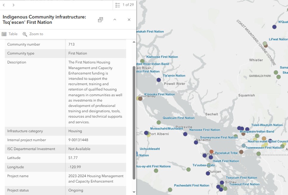
Indigenous Community Infrastructure dataset
Indigenous Community Infrastructure
The Indigenous Community Infrastructure dataset presents infrastructure projects across Canada that are supported by Indigenous Services Canada (ISC) supported by targeted infrastructure funding. The communities linked to these projects on the map are First Nations, Tribal Councils or other Indigenous organizations that have received project funds and/or are intended users of these projects. The dataset is used to showcase where and how investments are carried out and demonstrate the government’s commitment to addressing socio-economic gaps between Indigenous and non-Indigenous communities in Canada and improving access to high-quality services. The dataset is updated quarterly to reflect new or changes to existing projects.
Indigenous Mining Agreements - Active
The Indigenous Mining Agreements dataset shows the location of and provides information on the Indigenous community's signatory to agreements, the types of agreements negotiated, exploration projects, and producing mines. The dataset is maintained and updated on an annual basis.
The following three datasets are included in the Crown-Indigenous treaties and agreements geospatial dataset collection. They represent the geographic boundaries of the solemn agreements between the Crown and Indigenous peoples that set out promises, obligations and benefits for parties.
Modern Treaties in Canada
The Modern Treaties (formerly known as the Post-1975 Treaties) dataset contains geographic boundaries as well as basic attribute data representing signed agreements that were negotiated between Indigenous groups, the Government of Canada and provincial and territorial governments after 1975. These boundaries represent the result of a negotiated First Nation’s claimed area. These boundaries are usually not surveyed but help to delineate the geographic extent of the rights of Indigenous beneficiaries defined within the agreement.
Historic Treaties in Canada
The Historic Treaties (formerly known as the Pre-1975 Treaties) dataset contains geographic boundaries as well as basic attribute data representing signed treaties that were negotiated between Indigenous peoples and the Crown between 1725 and 1929. These boundaries represent the historic treaties signed after 1763, which designated large areas of First Nations land, to the Crown (transferring their Aboriginal title to the Crown) in exchange for reserve lands and other benefits.
Indigenous Agreements in Canada
The Indigenous agreements dataset contains geographic boundaries as well as basic attribute data representing established protocols in place for consultation processes, self-government agreements and other signed agreements between Indigenous groups and the Crown. These arrangements address many Indigenous and northern affairs related matters, such as education, economic development, child and family services, health, and housing, that have not been addressed by treaties or through other means.