Enabling infrastructure project collaboration with GeoVerra’s ArcGIS solutions
Communication and collaboration are at the core of effectively facilitating infrastructure projects, both big and small. However, with numerous stakeholders involved, such as project managers, contractors, consultants, and owner operators, achieving a common understanding of a project’s status can be a challenge.
While project hub sites and online portals can be effective for organizing and communicating a project’s status, accessing reliable and consistent data still stands as a primary challenge in delivering infrastructure projects on time, within design specification, and on budget. Information is often trickled down through progress meetings and reports from a variety of disciplines, such as engineering, designers, environmental consultants, surveyors, and legal teams. Project data from each group is frequently siloed, and in different formats, which can cause confusion among consultants, leading to project delays and increased costs.
AEC (Architecture, Engineering, and Construction) firms are at the forefront of infrastructure projects in Canada by driving innovation and ensuring the effective execution of complex initiatives. They are pivotal in designing and constructing essential infrastructure such as transportation networks, utility systems, and buildings. Their expertise not only ensures compliance with regulatory standards but also integrates advancements in smart infrastructure and environmental stewardship, contributing to the development of resilient, future-ready infrastructure across Canada.
However, according to a report by McKinsey & Company, these AEC firms overspend on 80% of their projects and over a third of a worker’s time is spent on handling conflicts, managing issues, and recreating data that is not transferred between project phases. Although the industry has seen an increased investment in digitization, particularly over the last few years, the move away from an analog environment has been slow in comparison to other markets. Still today, many AEC organization have yet to adopt digital analytical solutions to their full potential.
“In the old days, everybody's data was on separate maps. You had a map for environmental, you had a map with the design, and you had another map with the network alignment on it and they didn't all come together,” explains Cindy Genkin, National Manager of Applied GIS at GeoVerra. “It was hard to keep up with what was going on, so this situation created the question, ‘How can we make the accessibility of the data better, more reliable and more consistent?’”
Established in 2020, as a result of a merger between the geomatics divisions of WSP and Altus Group, GeoVerra is recognized as one of Canada’s largest geomatics firms with over 100 years of legacy company experience. The service organization provides land surveying, engineering, mapping, forestry, environmental and geospatial solutions for clients across diverse sectors including energy, transportation, and utilities. Having launched during the pandemic, GeoVerra has been hybrid from the start and identified early on the need to connect online to ensure productive collaboration with clients and as an organization.
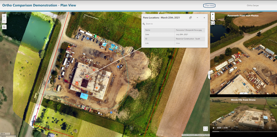
A custom GIS portal by GeoVerra for the City of Grimsby’s construction monitoring.
Pulling data together with ArcGIS
GeoVerra has partnered with Esri Canada since its inception. Using ArcGIS Enterprise as the backbone of its custom portals and their proprietary solution, GV View, GeoVerra can pull project data from its own Enterprise Resource Planning (ERP) system into the ArcGIS environment. By doing so, GeoVerra offers their AEC clients comprehensive mapping and GIS solutions that can significantly reduce inefficiencies, risks, and miscommunications on projects.
With all location-based project insights, deliverables, and visualizations in one place, collaboration and communication between all levels of contractors and project stakeholders are streamlined and more transparent.
“ArcGIS tools empower AEC firms to seamlessly collaborate on infrastructure projects by providing a unified platform for data integration, real-time analysis, and stakeholder engagement,” explains Robert Murdoch, Director for the AEC team at Esri Canada. “This approach is exemplified by firms like GeoVerra, whose innovative use of ArcGIS has significantly enhanced many project outcomes, demonstrating the critical role of advanced technology in delivering successful infrastructure projects.”
Driving collective understanding and collaboration with project portals
In contrast to the difficulty of keeping paper maps accurately updated within tight timeframes and continuously verifying on-hand information, GeoVerra’s online GIS portals make data more readily accessible throughout a project. “It is a meeting place of data,” explains Genkin. “They are a wealth of information and you understand that it is current, correct, and as up-to-date as possible.”
GeoVerra’s portals provide a visual reference point for all those working on a project, whether remotely in the field or office, and are scalable to projects of all sizes. With more reliable and consistent data that reflects ongoing project progress in one convenient location, teams can openly collaborate and make data-driven decisions.
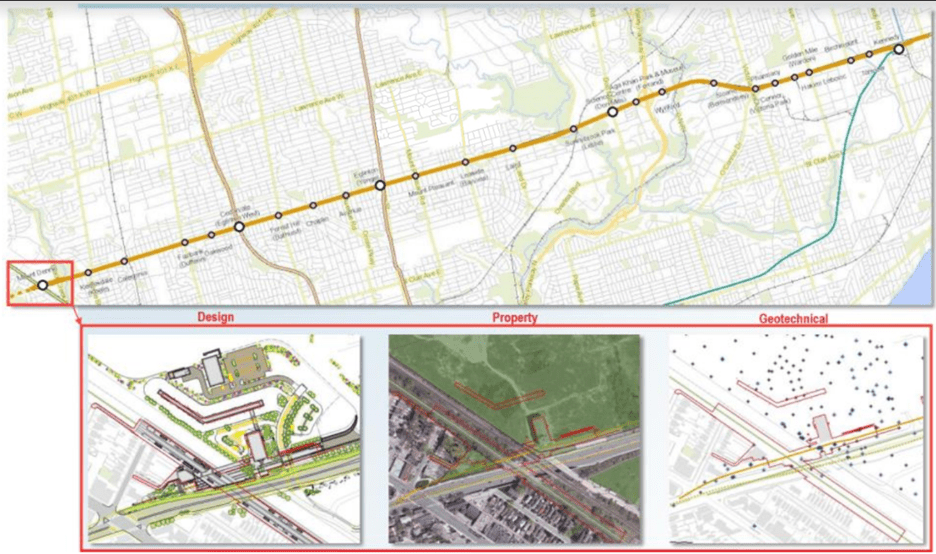
A custom portal for Eglinton Crosstown demonstrating a multi-disciplinary project (design, geotechnical and property).
Missing pieces of critical data, such as a right-of-way in a new development or project issues can also be more easily identified and communicated, avoiding potential project delays or extra costs, and mitigating risks. For example, on a recent municipal project in Ontario, once all the boundary maps were brought together in the portal, it became clear that a needed easement was missed for a location where work was required. “If that had gone unnoticed into the next stage, into construction…that could have been a delay and it could have been very costly,” says Genkin. “In the past, who knows when that would have been caught? Just because the data wasn't all in one place.”
Additionally, the tailored portals allow for enhanced communication and collaboration between field crews, consultants, and project managers through real-time updates.
![]()
GeoVerra project tracking dashboard showcasing sidewalk inspection statistics.
In supporting a sidewalk inspection project, GeoVerra created a custom portal that visualized each region of the city and divided the regions into manageable areas needing inspection for tripping hazards. The mobile-accessible portal indicated which areas had already been assigned and which remained to be addressed. With all the information staff needed tracked in a central location, project efficiency and productivity increased by three or four times compared to the previous manual process of tracking through Microsoft Excel.
Strengthening internal information sharing
GeoVerra’s team members use GV View as a central spatial data repository, where standardized information can be shared across the company, ensuring that everyone is using the most current data. It acts as a “single source of truth,” explains Patrick Leclair, GIS Systems Lead at GeoVerra, and means “everyone’s speaking the same language” when maps and project data are referenced.
With a central hub housing all legacy organization projects as well as current project plans, both GeoVerra project managers and clients can easily access and review project information, schedules and deliverables. Through the ArcGIS API for Javascript, 560,000 projects are currently viewable on the GV View Map, including 471,000 projects from the legacy companies that formed GeoVerra.
This allows project managers to quickly visualize the location of current and historical work, while clients can access their own projects. For example, a client in the upstream Oil & Gas sector can view the hundreds of wellsites and pipelines surveyed by GeoVerra. “[GV View] is a one-stop shop for any spatial information and data. It can really help the collaboration between the different project managers and their clients in a secure environment,” says Leclair.
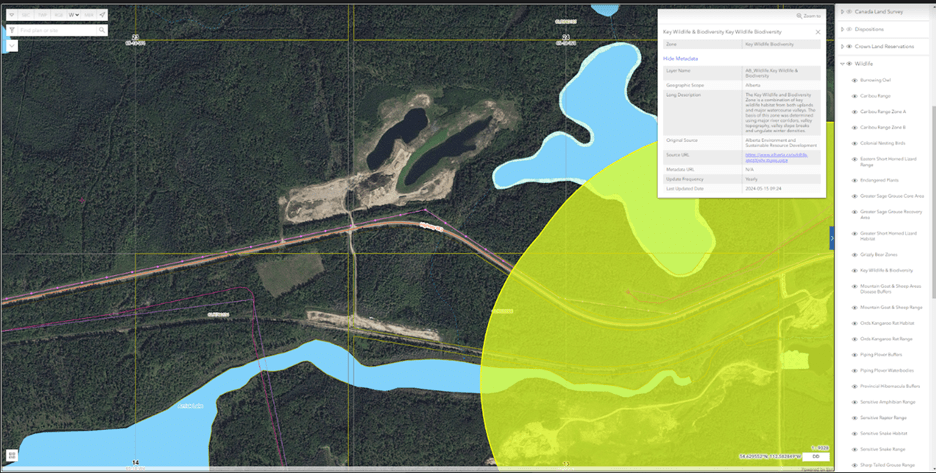
GV View Map illustrating regulatory data layer of wildlife sensitive area.
With everything viewable on a single map, and stakeholders able to access, add, and modify datasets, the number of data silos and effort to keep data up-to-date is reduced, improving work processes and quality. Additionally, 400+ spatial data layers – acquired from dozens of data providers on GV View – can be visualized on GV View Map with individual project data, providing teams with critical information to make decisions.
As the AEC industry evolves and projects expand to include greater amounts of information, the adoption of innovative digitization tools and GIS mapping solutions will propel effective collaboration.
Visit our AEC industry page for more.