Embracing GIS in AEC: The key to industry-wide digital transformation
Avoid costly mistakes and spot risks early. In this first post of our series, see how connected data helps you tackle challenges like land-use conflicts and outdated designs for smoother, smarter workflows.
Overview
The Architecture, Engineering and Construction (AEC) industry is experiencing a significant shift toward digital transformation. Geographic information system (GIS) solutions are at the forefront of this movement, providing powerful tools that integrate spatial intelligence with traditional project workflows. However, despite the proven benefits of GIS, adoption across the industry remains uneven. In this post, we’ll explore the value of GIS in AEC, common challenges in adoption and how organizations can successfully integrate GIS into their existing processes.
The growing need for GIS in AEC
The AEC industry is under constant pressure to improve efficiency, reduce costs and enhance collaboration. GIS offers a comprehensive solution by providing location-based insights that improve planning, design and asset management. Some of the key benefits include:
- Enhanced decision-making: GIS enables data-driven decision-making by visualizing and analyzing spatial relationships. It allows decision-makers to assess project scenarios by integrating multiple datasets—such as traffic patterns, population density, environmental constraints, flood zones and zoning regulations—into a single, interactive map. Beyond physical factors, GIS supports social impact assessments by analyzing demographics and service accessibility. It also aids economic evaluations through cost-benefit analysis, investment optimization and technical considerations like asset management and risk assessment. By providing a holistic view of spatial, environmental, social and economic factors, GIS enhances predictive capabilities and ensures more informed, sustainable planning.
- Improved collaboration: Stakeholders across different disciplines can access and share geospatial data seamlessly. Traditional AEC workflows often involve multiple teams working in silos, leading to inefficiencies and miscommunication. Data copies and transfers between systems further complicate collaboration, creating version control issues and outdated information. With GIS, engineers, architects and project managers can collaborate in real time, accessing a Common Data Environment (CDE) of spatial data that updates dynamically. This ensures that design changes, environmental impacts and construction progress are consistently reflected across all teams, reducing the risk of errors, redundancies and costly rework.
- Risk reduction: GIS helps identify potential project risks such as environmental constraints, land-use conflicts and regulatory compliance issues. By integrating GIS into the project lifecycle, AEC firms can perform early risk assessments and scenario planning. For instance, a construction company can overlay land-use data with seismic activity records to determine whether a site is at high risk for earthquakes. Additionally, GIS enables real-time monitoring of environmental conditions, allowing teams to mitigate risks related to erosion, water contamination or habitat disruption before they become liabilities. Beyond environmental and regulatory risks, GIS also enhances worker health and safety by identifying hazardous conditions, optimizing site logistics, and ensuring compliance with safety regulations. By mapping high-risk zones, monitoring weather conditions and tracking site access, GIS helps reduce workplace accidents and improve emergency response planning.
- Lifecycle management: From site selection to asset maintenance, GIS plays a crucial role in managing infrastructure projects over time. Rather than treating GIS as a one-time planning tool, AEC firms can leverage it for ongoing asset management. By creating digital twins—virtual replicas of physical assets that integrate real-time data—organizations can monitor infrastructure health, schedule predictive maintenance and optimize operational efficiency. This results in reduced maintenance costs and extends the lifespan of critical infrastructure.
Improved data flows will drive better decisions and shape the next evolution of how we design, manage and optimize infrastructure, utilities, transportation and logistics.
-
Sustainability and resilience: GIS supports environmental assessments and helps organizations plan for climate change impacts, ensuring long-term resilience. As global climate concerns rise, AEC firms are increasingly required to consider sustainability in their designs. GIS enables firms to model future climate scenarios, such as sea level rise and extreme weather events, to develop resilient infrastructure. Additionally, GIS facilitates green infrastructure planning by identifying optimal locations for renewable energy installations, sustainable drainage systems and urban green spaces.
Despite these benefits, many AEC firms are still in the early stages of GIS adoption. So, what are the barriers holding them back?
Challenges in GIS adoption
Several factors contribute to the slow adoption of GIS in the AEC industry, including:
-
Lack of awareness and understanding: Many firms see GIS as a niche tool rather than a core component of their workflows. A common misconception is that GIS is only relevant to geographers or surveyors, rather than being a tool that enhances every stage of the AEC workflow. More than just a mapping tool, GIS is a comprehensive data science platform that enables advanced spatial analysis, predictive modeling and real-time data integration, providing insights far beyond a simple map. To bridge this knowledge gap, companies must invest in educational initiatives and training programs that demonstrate GIS’s practical applications in design, construction and facility management.
-
Resistance to change: Traditional workflows are deeply ingrained, and adopting new technology requires a shift in mindset and processes. Many AEC professionals are comfortable with existing CAD and BIM software, and integrating GIS may initially seem like an unnecessary disruption. However, firms that successfully implement GIS adoption strategies—such as appointing GIS champions within teams and gradually introducing GIS-based solutions—can ease the transition and improve acceptance.
-
Data silos: AEC projects involve multiple disciplines, with each department relying on its own data management solutions, making system integration challenging. Often, geospatial data is collected and stored separately from engineering data, leading to inefficiencies and duplicated efforts. To address this, firms should implement data governance policies and interoperability frameworks that enable seamless data sharing between GIS, BIM and CAD platforms.
-
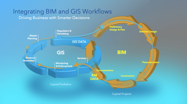
Interoperability concerns: Many AEC professionals rely on Autodesk solutions such as AutoCAD and Revit, and they are unsure how GIS fits into their design and construction workflows. This challenge can be addressed through software integrations, such as Esri’s ArcGIS GeoBIM, which connects geospatial intelligence with BIM models, enabling users to visualize infrastructure projects in their broader spatial context. Through the strategic alliance agreement between Esri and Autodesk, these integrations continue to evolve, ensuring seamless data exchange and enhanced collaboration between GIS and BIM environments. This advancement ultimately drives more efficient and informed decision-making.
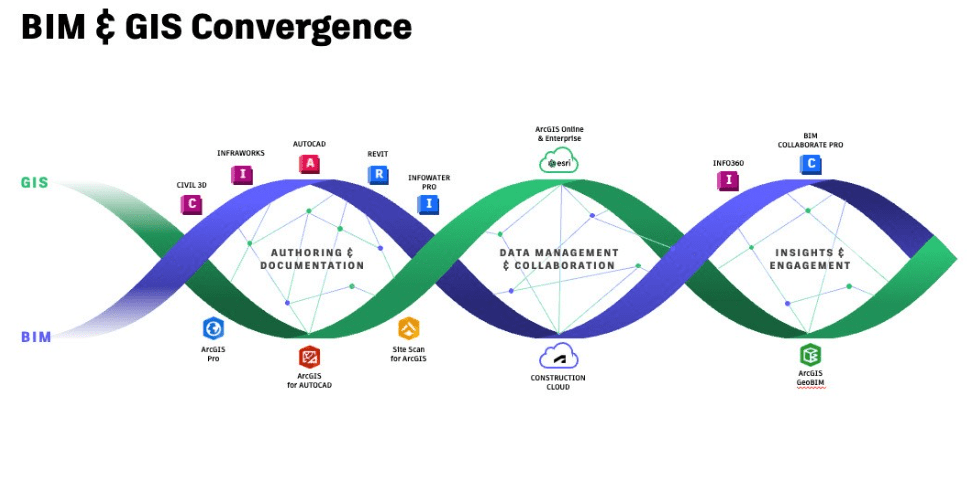 From desktop applications to cloud-based GIS integrations, the convergence of BIM and GIS is transforming how infrastructure assets are planned, designed, delivered and managed.
-
Perceived high costs: The initial investment in GIS technology and training can deter firms from adopting it, even if the long-term benefits outweigh the costs. Organizations should conduct cost-benefit analyses to quantify the savings and efficiencies gained through GIS adoption. Additionally, cloud-based GIS solutions and Software-as-a-Service (SaaS) models provide more flexible and scalable options that reduce upfront costs.
Strategies for successful GIS adoption
To successfully adopt GIS, AEC firms should focus on the following key strategies:
-
Education and awareness: Providing training and resources to help teams understand the value of GIS and how it complements existing workflows.
-
Seamless integration with existing tools: Leveraging solutions such as Esri’s integration with Autodesk, including ArcGIS GeoBIM, connects GIS and BIM for a more holistic project view.
-
Leadership buy-in: Gaining support from management to drive digital transformation initiatives and allocate resources for GIS implementation.
-
Pilot projects: Starting small with pilot projects to demonstrate the real-world impact of GIS before scaling up adoption. These projects help showcase measurable ROI and time savings while minimizing data duplication and versioning risks, providing a clear case for broader implementation.
-
Breaking down data silos: Establishing data-sharing protocols to ensure geospatial information is accessible across departments.
-
Developing a GIS strategy: Creating a roadmap for long-term GIS adoption, including goals, benchmarks and key performance indicators (KPIs).
Conclusion
The adoption of GIS in the AEC industry is not just a technological upgrade—it’s a strategic imperative for firms looking to stay competitive in a rapidly evolving landscape. While challenges exist, organizations that invest in GIS education, integration and leadership support will reap the benefits of improved decision-making, collaboration and project success.
GIS is becoming a critical part of AEC workflows, and firms that take proactive steps toward adoption will be better positioned for future success. By embracing GIS technology and leveraging its integration with Autodesk tools, AEC professionals can drive innovation, efficiency and resilience in their projects.
In our next post, we’ll take a deeper dive into the technical integration of Autodesk and Esri tools, exploring how technology is making GIS adoption more seamless for AEC professionals. Stay tuned!
Questions? Contact us at esri.ca/aec
Learn how your AEC peers are improving efficiency, reducing risks and strengthening decision-making with GIS: resources.esri.ca/aec.