ArcGIS AllSource: Intelligence analysis powered by GIS
ArcGIS AllSource enables intelligence operations to action geographic information system (GIS)-based information by combining relational geodatabases, 2D and 3D visualization, field applications and data analysis capabilities into a single powerful solution. Discover a few of AllSource’s capabilities, as well as further reading and training resources, in this blog post by Esri Canada certified ArcGIS instructor Raymond Caron.
If GIS is the science of where, then ArcGIS AllSource is the solution that enables military, intelligence and law enforcement agencies as well as private sector organizations to apply information derived from that science to their activities. AllSource is a suite of tools that work together within the ArcGIS geospatial platform to provide comprehensive information management and action capabilities to intelligence organizations. It’s only limited by the accuracy and coverage of the datasets, technical know-how and imagination that go into it. Esri Canada is well placed to show you how to use it—you only need to imagine what you want to do.
Logistical asset management
The power of a geodatabase is directly correlated to the accuracy of the information contained within it. Even with the advent of artificial intelligence, what you can accomplish with your GIS is limited by the datasets stored within your geodatabase. The ArcGIS database functionality is what sets it apart from other relational databases. It provides tools to enable the creation or updating of datapoints from the field, in real time, using mobile applications in a secure environment. ArcGIS also supports the integration of multiple sources of real-time information to help visualize events as they unfold and to provide the means to make informed, up-to-the-minute decisions to support activities.
By leveraging relational geodatabase functionality and through the use of many highly customizable ArcGIS mobile applications such as ArcGIS Field Maps, ArcGIS Survey123, ArcGIS QuickCapture and the web application ArcGIS Dashboards, the ArcGIS geospatial platform can manage not only the location and visualization of assets in real time, but also the manpower, equipment, parts and status of the components that form that asset, and the requests for that asset.
For instance, if a critical asset in the field experiences a malfunction due to a part that is in short supply, AllSource can create a notification for that event, then help locate a working part in an underutilized asset. AllSource can then be used to submit a request to appropriate the part using the fastest transportation options available, also determined using AllSource.
Simplicity in asset tracking
ArcGIS AllSource simplifies the application and use of a wide array of symbols used to identify and visualize specific assets and their capabilities in 2D or 3D, while streamlining the asset information update workflow. It allows users to apply a wide range of standard military symbologies to their mapping and can construct or integrate new symbols. AllSource supports real-time data updates and is compatible with ArcGIS Velocity, which can manage, process and integrate datasets to provide comprehensive real-time tracking of assets using dictionary symbology.
Operational environment
By combining high-resolution remote sensing from satellite, LiDAR or drone imagery with intelligence, AllSource can create a 2D or 3D model of the operational environment, enabling planning activities. Using tools specifically designed for AllSource, a user can identify potential vantage points and construct a plan that can be updated in real time as strategic intelligence becomes available. AllSource can also analyze terrain for traversal difficulty, providing a travel time/distance analysis for logistics.
Using visualization effects and layer grouping, different aspects of the operational environment can be visualized, such as effective radar or GPS jamming range.
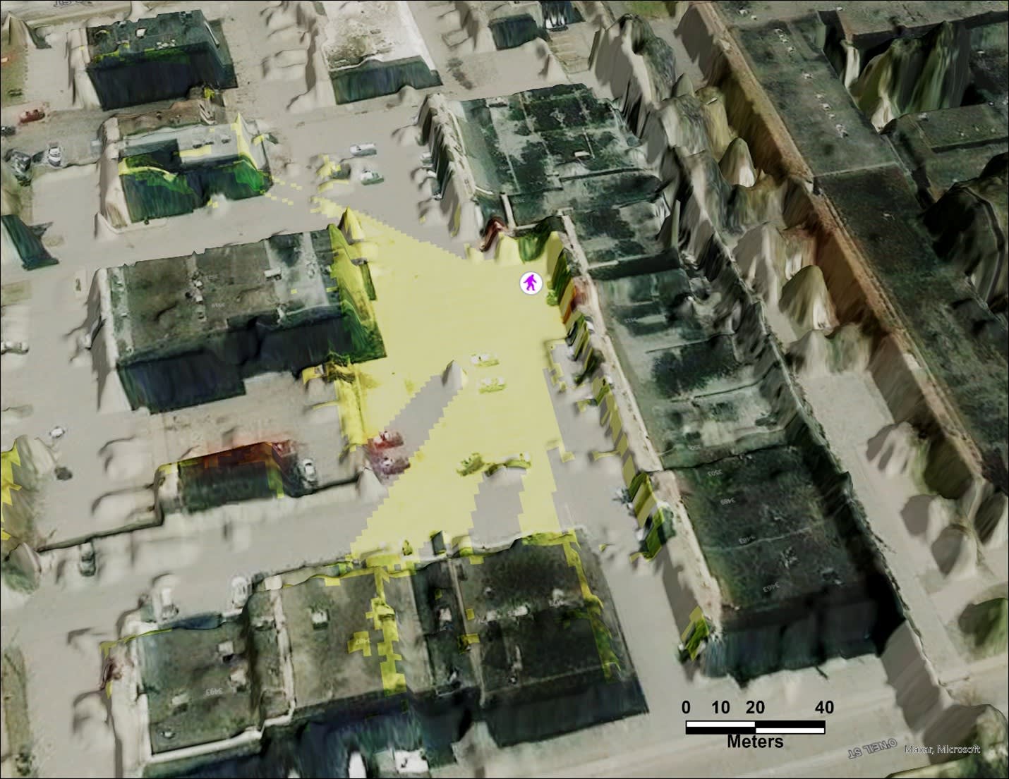
Example simple visibility analysis was conducted using only two operational layers: a point layer to represent the observer (person walking), and a digital surface model created using LiDAR at a resolution of one metre. A satellite imagery basemap is included with AllSource. Areas that are visible to the observer are shown in yellow.
Data analysis & intelligence
AllSource incorporates standard data analysis tools such as a suitability modeller, network analysis, visibility analysis and exploratory analysis. It also includes tools that can analyze large datasets for statistical significance in time and space, such as a movement analysis toolset that can comb cellular data for co-travelers, meeting locations, frequented locations and more. It can also create a customized link chart to help visualize relational anomalies in data.
AllSource also includes the LocateXT analysis toolset, which can analyze unstructured data across an array of standard file types and pick out location information with associated attributes.
When combined with ArcGIS Velocity, intelligence and a sensor network, specific events can be quickly triangulated and located in real time.
Related reading
- Link charts in ArcGIS AllSource
- ArcGIS LocateXT: Geo-enabling your unstructured data
- ArcGIS AllSource articles
- Asset tracking and analysis
Related training
Want to discover the power of ArcGIS AllSource in a guided learning environment? As Esri-certified GIS instructors familiar with geoscience datasets, Esri Canada’s Training team can guide you through the essential geoscience workflows in an instructor-led course customized for military, intelligence and law enforcement. Our ArcGIS AllSource courses, Introduction to Geospatial Concepts for Intelligence Using ArcGIS AllSource and the more advanced Using ArcGIS AllSource for Geospatial Intelligence Analysis, both cover a wide range of functionality and workflows.
Want to explore the field mobility capabilities of ArcGIS, including applications like Field Maps, Survey123, QuickCapture and Dashboards? Our instructor-led Field Data Collection and Management Using ArcGIS course is right for you.
To stay informed about all the latest training opportunities at Esri Canada, visit Esri Canada’s Communication Preference Centre and select the “Training” checkbox to get a monthly roundup straight to your inbox.