Mascouche propels its team forward with Esri Canada's Advantage Program
The dynamic city of Mascouche, located in Montréal's northern suburbs, stands out for its rapid growth and daring municipal innovation. In recent years, the municipality has chosen to focus on GIS to upgrade its services and better meet the needs of its citizens. Esri Canada's Advantage Program is at the heart of this transformation, serving as a strategic partner offering customized support, cutting-edge tools, and renowned expertise.
Mission-driven leadership and a committed team
Martin Fafard, head of GIS, and his team's adaptability have been key to Mascouche's success. Since the GIS division was created in January 2022, Mascouche has attracted talented people and built a culture of innovation based on the use of geospatial technologies.
“Our goal is to offer more efficient and transparent services to citizens while also optimizing the management of municipal infrastructure,” explains Martin Fafard. This vision became a reality with support from Esri Canada, which adapted its solutions to the city's realities and ambitions.
ArcGIS Enterprise: Moving toward integrated and collaborative management
The July 2022 implementation of ArcGIS Enterprise was a key milestone in upgrading municipal services. With support from a team of experts at Esri Canada, Mascouche was able to:
- install and configure a GIS architecture adapted to its needs.
- migrate its data towards a secure and expandable platform.
- encourage collaboration between different municipal departments (urban planning, public works, environment).
- gain access to specialized training and online learning resources to strengthen internal skills.
This digital transformation has enabled the city to improve the quality of its web maps, promote the use of authorized geospatial information and implement clear and standardized processes for data management.
ArcGIS Utility Network: Expertise-driven transformation
The implementation of ArcGIS Utility Network in Mascouche was more than a simple technology rollout; it was a comprehensive professional support project, coordinated through Esri Canada’s Advantage Program in proof-of-concept mode. From the very beginning, the city enlisted Esri Canada's consulting services to conduct a proof of concept on its water network. The goal was to enable the municipal team to become self-sufficient in using this cutting-edge solution.
- There were many challenges:
- Lack of topological AutoCAD drawings
- Lack of a solution in place for viewing in the field
- The need to review the exact positioning of assets
Despite these challenges, Martin Fafard selected a cutting-edge solution: Utility Network!
The project was built on a structured and progressive approach:
- Prior training: Before starting the workshops, the Mascouche team underwent ArcGIS training in utility network management, ensuring a solid knowledge base.
- Customized coaching: Esri Canada then offered five half-day hands-on workshops led by experts like Trevor Webb (application specialist, Public Services Group) and Jimmy Bernatchez (benefits program advisor). This coaching provided an opportunity to work on data modelling, water network configuration, subnetwork management, application of connectivity rules and process documentation.
- Ongoing support: Throughout the project, Esri Canada provided rigorous follow-up, working closely with Martin Fafard, head of GIS at the City of Mascouche. Communications were structured, deliverables were validated at each stage and decisions were made collaboratively to ensure the project's success.
The results that Utility Network achieved for Mascouche
- Precise and dynamic visuals of the water and wastewater networks
- Decrease in emergency responses due to better tracking
- Optimization of operating costs
- Increased independence for the municipal team with the use of ArcGIS Field Maps in the field
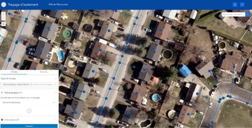
Figure 1: Tracking with ArcGIS Experience Builder
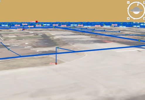
One part of the network in 3D
To sum up, the success of Utility Network in Mascouche is based on a collaborative approach, where Esri Canada's expertise has been a key factor in transforming municipal management and promoting innovation for a better service to citizens.
Testing community technologies with the Citizen Problem Reporter and ArcGIS Solutions
Innovation in Mascouche is driven by experimentation and acceptance of new technologies. Rather than settling on a single solution, the city has chosen to test several tools to better understand the expectations of its residents and adapt its municipal services accordingly.
Among these initiatives, the Citizen Problem Reporter application integrated into the ArcGIS Solutions suite was assessed as a means of bringing the administration closer to the public. This pilot project enabled the GIS team to analyze the concrete impact of collaborative technologies, gather feedback and adjust its choices based on actual needs in the field.
A partnership focused on training, transfer of knowledge and access to Esri Canada's experienced experts!
Esri Canada's Advantage Program goes beyond technology projects to focus on knowledge transfer and ongoing training. Mascouche has gained exclusive access to online courses, webinars and specialized workshops, allowing the team to stay at the forefront of geospatial innovation.
Regular meetings with Esri Canada experts have enabled the exchange of best practices, resolution of technical challenges and forecasting of future needs. This training component ensures the city's sustainability and independence.
Thanks to its leadership, the commitment of its team and the strength of its partnership with Esri Canada, Mascouche has established itself as a model in municipal geomatics. Esri Canada's Advantage Program has proven to be a catalyst for success, propelling the city toward smart, collaborative, community-based management.
If you have ambitious plans for your organization’s GIS function but need help implementing them, Esri Canada’s Advantage Program is right for you. Or, if you’re interested in a 360 evaluation of your organization’s current geospatial maturity that provides rapid time-to-value, consider our Location Intelligence 360 service.
This post was written in French by Jimmy Bernatchez and can be viewed here.