Beyond the hype: how geospatial AI creates value across organizations
Geospatial AI is rapidly evolving in every conversation across industries, but where does it actually create meaningful value? Beyond the hype, the real opportunity isn't just what geospatial AI can do, but what it can enable. In this blog, you’ll discover five key ways organizations can leverage geospatial AI to improve operations today while building capacity, resilience and innovation for the future.
Available diverse geospatial data coupled with advances in AI models, assistants and emerging agents are expanding what organizations can automate, analyze and understand at scale. But as new AI capabilities and headlines emerge almost daily, keeping up with the technology is only part of the challenge.
For organizations, the more important question is: where can geospatial AI create meaningful value for us?
Answering it requires moving beyond what geospatial AI can do to what it can enable. To find those opportunities, we first need to understand what makes geospatial AI distinct and why adding geographic context to AI matters.
What makes geospatial AI different? Geography as context
AI can interpret text, tables, images and other data, but many organizational questions depend on something more fundamental: where. A model might identify infrastructure at risk, for example, but understanding which assets are actually exposed to a wildfire requires geographic context such as proximity to the fire, terrain, surrounding conditions and how those factors change over time.
This is the geospatial gap that geospatial AI helps bridge. By grounding AI in trusted geospatial data and spatial relationships, such as distance, connectivity and spatial-temporal patterns, geospatial AI connects AI reasoning to real-world context.
For organizations, this distinction matters. Geography is not simply another data attribute; when location influences an outcome, spatial context can turn AI-generated information into more relevant and actionable intelligence.
Geospatial AI organizational value: balancing exploitation and exploration
Organizations can approach AI in two complementary ways: exploitation, using AI to improve and optimize what they already do; and exploration, using it to discover new possibilities and capabilities. The ability to pursue both is often described as AI ambidexterity – the capacity to optimize what works today while exploring what could create value tomorrow.
Drawing on insights from industry perspectives and academic resources, five recurring pathways emerge through which organizations can realize geospatial AI ambidexterity:
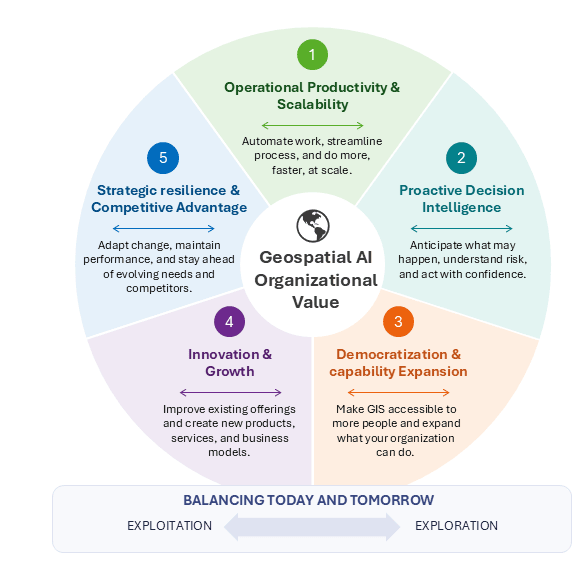
Five pathways through which geospatial AI creates organizational value
1. Operational efficiency & scalability
Geospatial AI can automate and accelerate routine geospatial work, reducing the human effort required for tasks such as feature extraction, change detection and code generation. For example, pre-trained AI models can accelerate feature extraction and change detection, while AI assistants can support Python code generation. More importantly, geospatial AI enables organizations to process volumes of imagery, sensor data and other geospatial information at a speed and scale that may not be practical through traditional approaches. The value goes beyond simply doing the same work faster: geospatial AI can expand operational capacity, optimize limited resources and make previously impractical workflows achievable at scale.
2. Proactive decision intelligence
Geospatial AI can help organizations move from understanding what is happening and where, to anticipating what may happen next. By integrating diverse historical data sources, applying predictive modelling and identifying spatial and temporal patterns, geospatial AI strengthens situational awareness, enables prediction and supports earlier risk identification. These insights can then be translated into actionable information through maps, dashboards and other decision-support tools. For example, predicted wildfire risk can be analyzed using machine learning methods, shared through web maps and dashboards and communicated to decision-makers and communities. The result is a shift from reactive responses toward more informed, proactive decisions.
3. Democratization & capability expansion
Geospatial AI can expand who can access, create and act on geospatial intelligence. Generative AI and natural-language interfaces lower technical barriers, enabling more people to ask spatial questions, discover data, generate code, perform analysis and interpret results. Agentic mapping solutions, like ArcGIS Data Explorer, are an example of how spatial insights can be accessible beyond GIS specialists. In doing so, geospatial AI augments existing human expertise by adding knowledge, tools and technical vocabulary to what people already know, extending what they are capable of accomplishing. This combination of broader access and human augmentation can expand organizational capacity while empowering more people to benefit from geospatial intelligence.
4. Innovation & growth
Geospatial AI can create value beyond improving existing operations by enabling new capabilities, services, and ways of working. AI assistants, for example, can make existing ArcGIS experiences more accessible and intuitive through natural-language interaction. At the same time, automation and AI-assisted content generation can free time and resources for experimentation and innovation. This creates opportunities to move beyond enhancing what already exists toward developing new offerings and solutions. What those opportunities look like will differ across organizations, shaped by their unique challenges, knowledge, communities and capacity to imagine what their future possibilities are.
5. Strategic resilience & competitive advantage
Geospatial AI can help organizations maintain performance as their workforce, resources and expectations change. For example, as experienced employees retire, AI agents can help capture and operate their knowledge, making established processes and expertise more accessible to others. Also, as expectations for faster and more accessible services grow, geospatial AI can help organizations modernize how people access location-based information and services, including through natural-language interactions and more responsive, context-aware experiences. Organizations that build these capabilities early are also better positioned to adopt emerging technologies and keep pace with changing needs, which can strengthen both long-term resilience and competitive advantage.
Conclusion: finding what geospatial AI can do for you
Finding value in geospatial AI starts with the organizational needs, not the technology itself. First, ask whether location and spatial relationships matter to the problem. Then consider where geospatial AI could make a meaningful difference:
- Efficiency: Can it reduce manual effort, optimize resources or increase capacity?
- Decision intelligence: Can it help us make faster, better or more proactive decisions?
- Democratization: Can it empower more people to access and use geospatial insights?
- Innovation: Can it improve an existing service and enable something new?
- Resilience & competitive advantage: Can it help us adapt to change, maintain performance and stay ahead of evolving needs?
Not every geospatial AI initiative needs to deliver value across all five areas. The goal is to identify where it can make the greatest measurable difference for your organization and the communities you serve.