Assembling a Basemap and Building Community with the Community Map of Canada
Read about how the Community Map of Canada creates Canada’s authoritative basemap and builds community along the way.
There is a certain Scandinavian big-box home store that sells out-of-the-box, often scalable, furniture that easily suits different tastes and needs (I think we all know which one it is!). I am currently moving apartments as I write this, so I have been thinking a lot about the assembly and disassembly of furniture lately. In doing so, I began wondering about how the building of furniture was similar to how we build an authoritative basemap like the Community Map of Canada.
Indeed, if moving into a new space means customizing it to best represent you – your personal style, your unique needs and your unique space and furniture arrangement – we become interior designers. If that’s the case, does that make us on the Community Map of Canada team… exterior designers (or even GeoDesigners)?
Check out the before and after of some of these communities’ contributions. In our opinion, the comparisons give the same satisfaction as room makeovers.
 Saint-Hyacinthe, Québec, on the Community Map of Canada before contribution (above) compared to after contribution (below).
All kidding aside, the Community Map of Canada works directly with communities to ensure that the basemap best represents their space (community), to assemble their data as if we were putting together a bookshelf and to design it in such a way that ensures the style suits their needs.
In this blog article, I’ll dive deeper into what it takes to assemble the Community Map of Canada basemap and to build community from coast to coast to coast.
Ready Out-of-the-Box and with Style Variations
Just like most items from this large Scandinavian furniture company, the Community Map of Canada is ready, out-of-the-box, with six main basemap styles. It also boasts multiple other stylistic variations easily available to suit your needs and style.
Want a minimal grey map that uses muted light grey colours that make your vector data pop? Consider using the LIGHT GREY basemap style.
Looking for a map that shows the orthometric imagery of the World and vector data of Canadian communities superposed atop it? Choose the HYBRID IMAGERY basemap style.
If you're looking for other creative basemap styles to complement your creative apps and maps, check out our Halloween basemap or our honeybee basemap styled like honey and with a bee’s black stripes? Using the ArcGIS Vector Tile Style Editor, dozens of custom basemap styles have been created and are available for use in our Custom Basemap Gallery.
Screenshots of creative custom basemap styles created by the Community Map of Canada team and available for use in the Custom Basemap Gallery. Clockwise from top left: Light Grey Topographic basemap style, Hybrid Imagery basemap style, Halloween basemap style, Honeybee basemap style.
Scalable and usable
This particular Scandinavian furniture and home brand is well-known for its scalability and usability across unique use cases. In terms of scalability, if you’re looking for a map with authoritative data at the federal, provincial and municipal scales, the Community Map of Canada accepts data from all levels of Canadian government as well as from First Nations. Look here to see all the communities we accept data from.

Locations of the 400+ Community Map of Canada contributors as of June 2024.
The Community Map of Canada is also focused on suiting various use cases. The Community Map can be accessed across the ArcGIS system for use in maps and apps and can also be easily set up as your organization’s default basemap.
Assembling the basemap
Unlike the previously mentioned furniture company, Esri Canada takes care of putting the basemap together once you’ve sent us your data. That’s what the Community Map of Canada team is for!
Nevertheless, here’s a fun infographic (or an ‘assembly manual’) outlining some of the steps involved in being a Community Map of Canada data contributor.
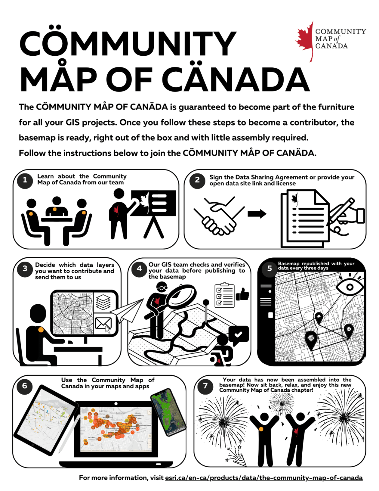
A Community Map of Canada basemap assembly ‘manual’ detailing the 7 main steps to build a basemap (with a simplicity inspired by a certain Scandinavian furniture brand).
Step 1: Learn about the Community Map of Canada from our team

Every Canadian community is different. That’s why the Community Map of Canada team (made from collaboration between regionally dedicated GIS Analysts and Technical Solutions Specialists) meets with each contributor before beginning the onboarding process to have a Discovery Call. These Calls help us learn about the unique context of each community. This helps us better collaborate with each community as they join the Community Map program and allows us to tailor the discussion and introduction to address their particular needs.
Step 2: Sign the Data Sharing Agreement (required for some sharing methods) or provide your open data site link and license

To share data to the Community Map of Canada basemap, signing a Data Sharing Agreement is necessary to outline all terms of data use and align expectations. This is only required for map package and REST URL contributions, not for contributors of open data. To share via Open Data, all you need is the link to an open data site (that also includes a valid open data license).
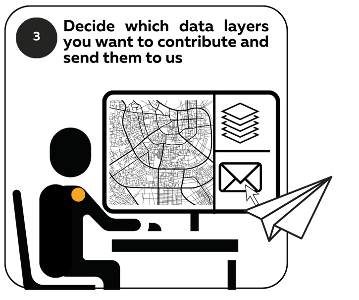
Step 3: Decide which data layers you want to contribute and send them to us. Take a look at a list of all data accepted and consider the different data contribution methods
Here is a list of all the ‘parts’ involved in the building of a basemap – all the data accepted to the Community Map of Canada:
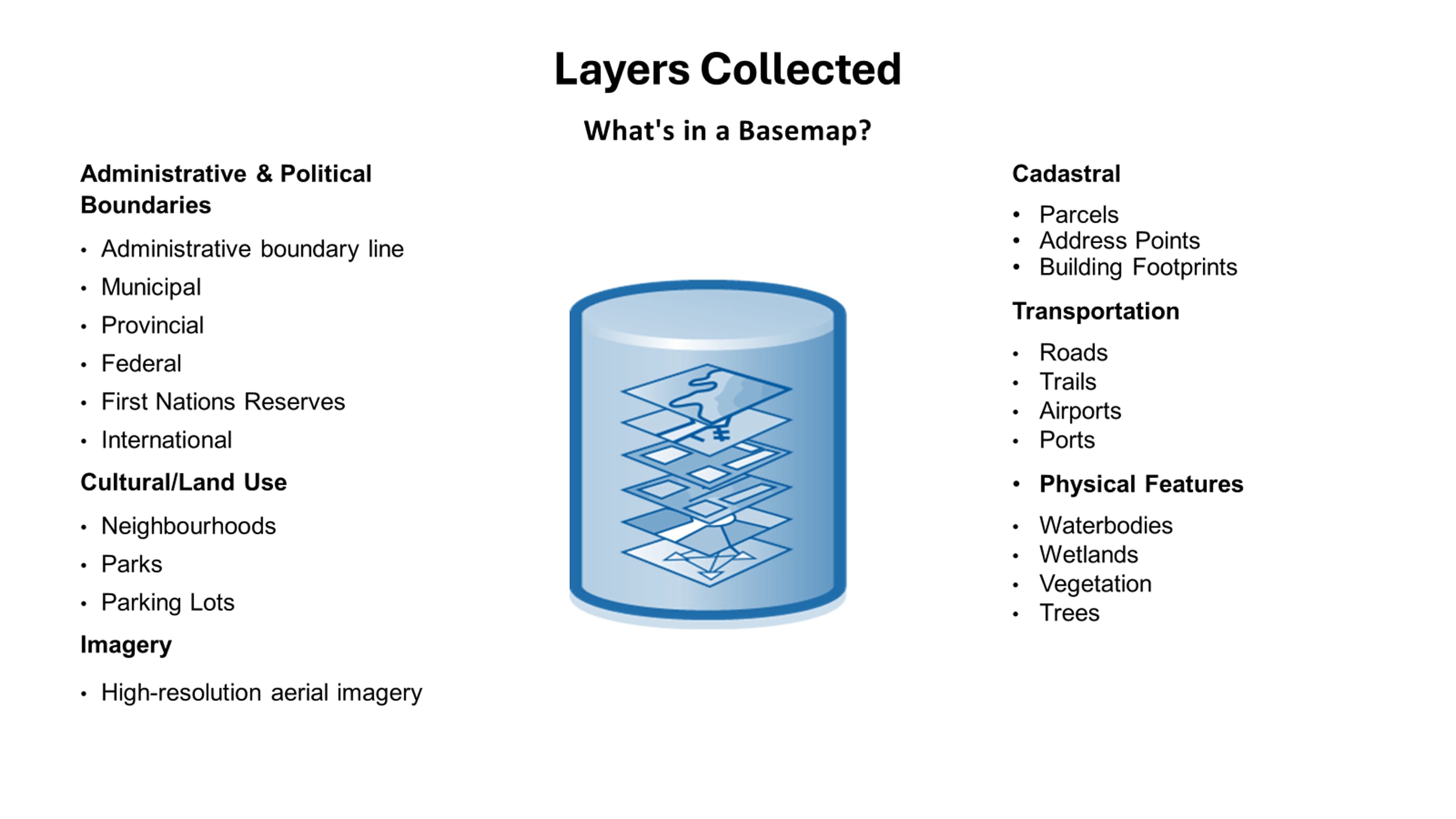
The list of data layers that communities can contribute to the Community Map of Canada for publication and inclusion.
With regards to how to get your data on the map, there are three main data contribution methods:
-
-
- Contribute data via Map Package: Simply ‘package up’ your data (like the GIS version of a ZIP folder or taping up a moving box) and share it with our ArcGIS Online group (we create the group and add your ArcGIS Online username to it). The process takes less than five minutes.
- Contribute data via REST URLs: If your organization has Hosted Feature Services with REST URLs, we are able to access the data and its updates dynamically. This is analogous to organizing movers who do the lifting for you!
- Contribute data via an Open Data Site: If your organization has an Open Data Site, the data is already available for use and integration in the Community Map of Canada. All that is required is the link and presence of a valid open data license on the site!
-
Step 4: Our GIS team checks and verifies your data before publishing to the basemap

Hang tight while the Community Map of Canada team works on integrating your data into our schema. The initial upload to the basemap takes a bit longer as it requires a review, but after the first contribution, further updates are much quicker. Uploading data to the basemap involves creating links between your data and the data schema in the GeoFoundation Exchange (GFX) which is an innovative cloud-based service that facilitates a collaborative data exchange to coordinate basemap production. This process is called ‘field mapping’ and involves matching community data to our basemap schema. Every community organizes their data differently and has their own schema for data management, so rather than asking communities to change the way they store their data, we work on incorporating communities’ data however it comes to us by ‘matching’ their fields with those of the GFX schema.
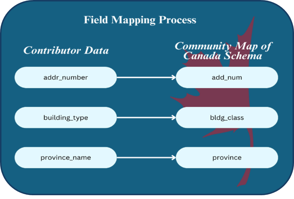
The field mapping process involves matching community data to Community Map of Canada schema.
Step 5: The basemap is republished with your data every three days
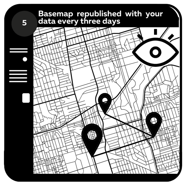
This rate of publication for a national basemap of this size is unparalleled and is definitely an upgrade for Canadian GIS users compared to other basemaps covering Canada (other default basemaps use external commercial sources for data and only update Canadian content quarterly).
As we all do in our own homes, if something is broken, we fix it and if our style and décor preferences have changed, we alter our homes to reflect those updates. We treat the Community Map of Canada the same way! If you spot an error on the basemap, you can use the Feedback App to submit the error and the team will work on getting the error resolved as quickly as possible.
And if you as a data contributor have updated data that would improve the representation of your community (e.g. street name change, new tree planted, old buildings demolished and replaced with a new building), simply re-send us your data contribution and it will be processed into the basemap. The Community Map is synced nightly and is republished every 72 hours, so any changes are almost immediately reflected on the basemap. How’s that for no assembly required?
Step 6: Use the Community Map of Canada in your maps and apps
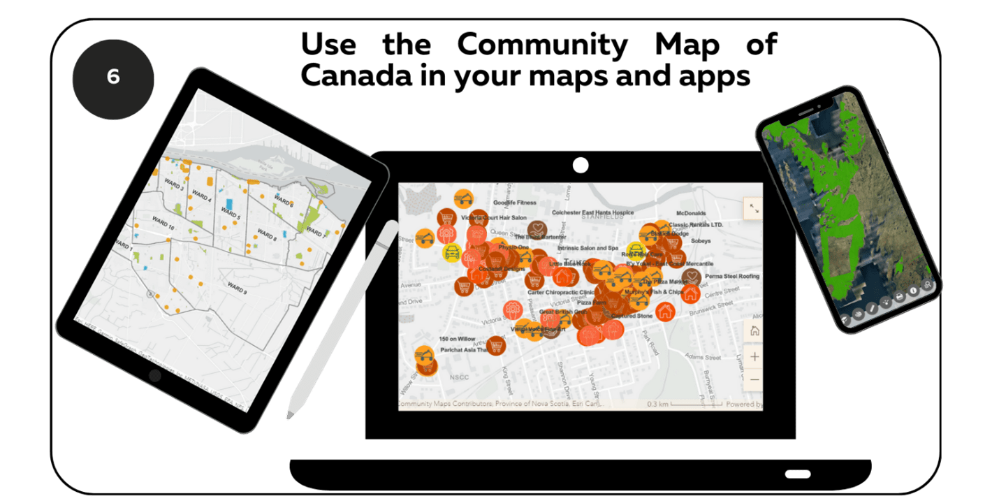
As mentioned above, the Community Map of Canada can be used in your apps and maps across the ArcGIS system. From ArcGIS Pro and ArcGIS Enterprise to ArcGIS Online and Experience Builder and from the Vector Tile Style Editor to ArcGIS StoryMaps, make sure you as a Canadian GIS user are using the Community Map as your default authoritative basemap!
Step 7: Your data has now been assembled into the basemap!

Now that your data has been contributed and assembled into the basemap by our team, sit back, relax and enjoy this new Community Map of Canada chapter. Share this new resource with your peers and colleagues - consider it a kind of housewarming party.
Building Community
Speaking of a party… while we might not have a food court boasting delicious Swedish meatballs, ice cream, and lingonberry jelly, we do organize quarterly virtual Happy Hour networking events available to our 400+ communities (in which we offer virtual food and drinks).
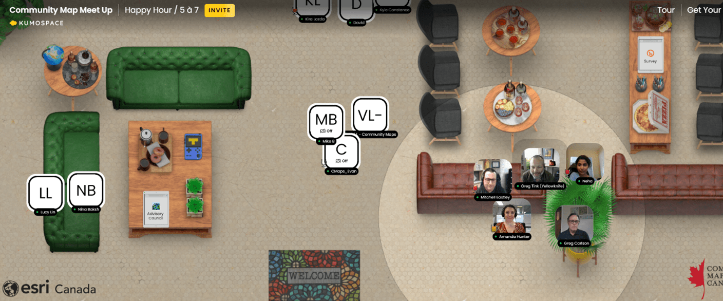
Screenshot from a Community Map of Canada networking event taking place in Kumospace, a virtual room where dozens of Canadian communities gather for bimonthly French and English events and to share their stories, best practices and successes. Note the virtual couches, refreshments, individuals and the sound radius (mimicking real-life audio ranges while at events) – don’t they all just make you want to join in on the fun?
The events involve community lightning presentations on informative topics like how GIS professionals and municipalities will be involved in Next Generation 9-1-1, how to level up your GIS game through participating in the Community Map and building municipal Hub Sites and how the Community Map of Canada helped the City of Yellowknife evacuate during a wildfire emergency. These events (hosted in French and in English) bring together dozens of Community Map communities and GIS professionals from across the country into a virtual space to share best practices, share lessons learned and, through the networking period, connect with others in similar professions and facing similar successes and challenges.
The Community Map of Canada also has a dedicated Advisory Council made up of a dozen community contributors and GIS professionals as well as Esri Canada and Community Map of Canada staff, all of whom unite quarterly to advocate for communities’ unique needs and to provide direction for the advancement of the Community Map.
For any general or specific questions about the Community Map of Canada or for help ‘assembling’ anything to do with your maps, apps and Community Map of Canada contributions, you can always email the team at communitymaps@esri.ca for a quick response.