Teaching and Learning GIS in the Age of AI (Part 2 of 3)
The GIS students who will stand out in the age of AI won't be the ones who use it most. They'll be the ones who use it with the clearest sense of what they're doing and why. That difference comes down to four skill clusters—and knowing which tools to reach for is only part of the story.
The first part of this series made a simple argument: AI tools are only as good as the judgment behind them. Building that judgment takes real engagement with spatial problems, not just exposure to polished outputs. For students entering GIS and geospatial programs today in Canada and elsewhere, that argument has immediate practical weight. The tools are already in students’ hands. AI is becoming part of how spatial data is collected, analyzed, visualized, and communicated. The real question is whether students are also building the foundations needed to use these tools critically and responsibly.
This post focuses on what those foundations actually look like: four interconnected skill clusters that matter for any GIS or geospatial student navigating an AI-saturated field. None of these are about avoiding AI; all of them are about using it well.
What the Tools Can't Tell You
There's a real tension at the centre of learning GIS right now. Students arrive with access to tools that can generate spatial workflows, write analysis code, suggest datasets, and produce polished map outputs in minutes. That's a genuine advantage, and it would be wrong to frame it otherwise. But there's a gap we need to be honest about. A tool that produces a reasonable-looking spatial output gives no signal about whether the reasoning behind it is indeed sound. And without enough experience to scrutinize that reasoning, students may have no reliable way of knowing when something has gone wrong.
The core issue is that spatial data is not neutral, and AI tools have no inherent awareness of that. What gets measured, how a study area gets divided, and what scale an analysis runs at are not incidental choices. They actively shape what an analysis can and cannot find. A result that looks robust under one set of geographic conditions may behave very differently under another. These are the kinds of sensitivities that take time and practice to develop an instinct for. Reading AI-generated outputs is not a substitute for that process.
The four skill areas below are where students begin to build that instinct.
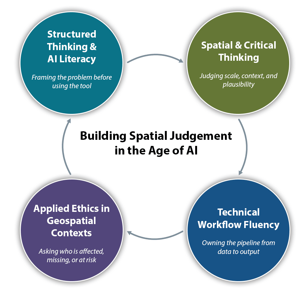
Four interconnected skill clusters GIS learners need to develop in the age of AI: structured thinking and AI literacy, spatial and critical thinking, technical workflow fluency, and applied ethics in geospatial contexts.
1. Structured Thinking and AI Literacy
Knowing how to frame a spatial problem before reaching for a tool is more important than knowing which tool to reach for. This means being able to translate a messy, real-world question into something an AI system can meaningfully engage with. It also means knowing how to ask for explanations, assumptions, and alternatives, rather than just answers.
Prompt quality is a useful concrete illustration. Consider the difference between these two approaches to the same problem:
Weak prompt: "Use AI to find the best place to build a new health clinic in Toronto."
Stronger prompt: "Help me design a GIS-based suitability workflow to identify candidate locations for a new public health clinic in Toronto. Consider population density, travel time to existing clinics, transit access, and neighbourhoods with higher proportions of seniors and low-income residents. Explain what datasets I would need, what spatial assumptions I should make explicit, how scale or aggregation could affect the result, and how I should validate the final suitability map."
The second prompt doesn't just request an output. It asks the system to make its reasoning visible. The difference isn't really about prompt engineering as a technical skill. It's about whether the student has already done the thinking that makes a useful prompt possible. You can't ask the right questions of a tool unless you already understand the problem well enough to know what the right questions are.
2. Spatial and Critical Thinking
This is the area where GIS learners have the most to lose if AI fills the gap prematurely, and the most to gain if they develop it deliberately. Spatial thinking means understanding that location, scale, and context are not just background details: they are active variables that shape what an analysis finds.
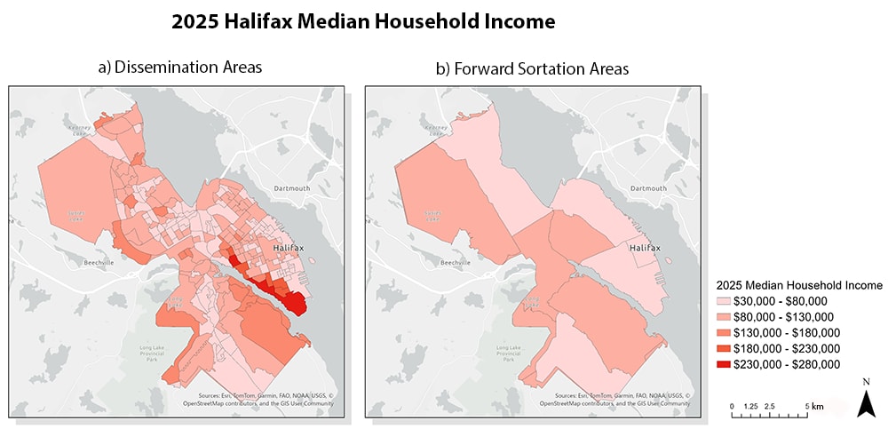
The same 2025 median household income data for Halifax mapped at two different levels of geographic aggregation. The underlying data is identical in both panels; only the boundary unit changes. Data source: Environics Analytics, 2025.
A good illustration is the modifiable areal unit problem, or MAUP. The same underlying data can produce meaningfully different patterns depending on the scale of aggregation or the boundaries used to summarize it. The two Halifax maps above show this directly: the income variation visible at the dissemination area level—concentrated pockets of high and low income across the city—flattens almost entirely when the same data is summarized using larger postal code boundaries (known as forward sortation areas). The underlying population has not changed; the geography has. The choice of areal unit and scale are judgment calls that require experience and domain knowledge. They cannot be reliably outsourced to a tool that doesn't know the landscape, literally or figuratively.
A related skill is data provenance literacy: knowing where a dataset came from, how it was produced, what it leaves out, and what uncertainty comes with it. AI can hide these issues by producing clean-looking outputs from imperfect data.
AI pipeline literacy belongs here too. In AI-based geospatial workflows, understanding what a model was trained on, how the training data was defined, and under what conditions the model should be expected to perform well or poorly is not advanced knowledge. It's basic due diligence. A land cover classification model trained on imagery from one biogeographic region may perform poorly on another. A model built on historical patterns may degrade as conditions change. Knowing when to trust an output, and when to question it, starts with understanding how the data was collected and how the pipeline was built.
3. Technical Workflow Fluency
Less glamorous than the others, but equally important, is the ability to understand data pipelines, write reproducible code, validate outputs, and diagnose problems when something goes wrong. AI can assist with all of these tasks, often impressively. But students who rely on AI-generated code without understanding it are building on an unstable foundation.
When something breaks in a real-world workflow—and it will—fixing it requires genuine understanding of what the pipeline is doing at each step. Fluency here doesn't mean memorizing syntax. It means understanding the logic well enough to take ownership of the process, to recognize when an output doesn't make sense, and to identify where in the chain the problem likely occurred.
This also means being able to explain methodological choices and uncertainties, not just the outputs that were produced. Employers across the GeoAI sector consistently look for graduates who can articulate the reasoning behind their work to colleagues, clients, and stakeholders who may not share the same technical background.
4. Applied Ethics in Geospatial Contexts
Generic AI ethics training tends to stay abstract: be fair, be transparent, respect privacy. In geospatial work, these aren't just values. They are operational requirements with specific, place-based implications.
Location data is among the most sensitive kinds of data there is. It can reveal where people live, worship, gather, and move. In spatial AI work, fairness means asking where a model is accurate and where it fails, and who bears the cost when an apparently objective map is wrong. Transparency means being explicit about what's in the training data and what isn't. Privacy means understanding the specific risks that location-based data introduces, not just data in the abstract.
In Canada, questions of Indigenous data sovereignty are a particularly concrete example of why geospatial ethics can't stay at the level of slogans. The OCAP® principles (Ownership, Control, Access, and Possession), established by the First Nations Information Governance Centre, make clear that First Nations data should be governed under First Nations authority at every stage: collection, storage, use, and sharing. For students going into public sector work, environmental assessment, or any project that touches on Indigenous communities or territories, this isn't a footnote. It's a professional obligation.
This is why geospatial ethics has to be taught as practice, not just principle. Students need to learn how ethical questions appear inside ordinary workflow decisions: which data to use, where the data comes from, who has authority over the data, which communities are represented, which uncertainties are disclosed, and who may be affected by the final output.
The Skills That Compound
The GeoAI roles employers are posting for right now don't just ask for technical proficiency. They ask for candidates who can evaluate outputs, communicate uncertainty, make defensible methodological choices, and navigate complex governance requirements. Those capabilities don't come from knowing how to use the current generation of tools. They come from knowing how to judge any generation of tools.
That's the compounding advantage. A student who builds genuine spatial understanding now will get more out of every future tool. The tools will change; the fundamentals of spatial reasoning, critical evaluation, and responsible practice will not. In a field where AI is accelerating what is possible, the students who stand out will not be the ones who use it most. They will be the ones who use it with purpose, with caution, and with a clear understanding of what they are doing, why they are doing it, and what the consequences may be.