On the Map with the Université Laval's Geography Department
Université Laval's Geography Department and Esri Canada's Education team co-hosted a mapmaking workshop at Collège de Champigny.
As part of activities surrounding the celebration of GIS Day, Université Laval's Geography Department organized an interactive mapmaking workshop with grade 7 students at the Collège de Champigny, located in the Sainte-Foy-Sillery-Cap-Rouge borough of Québec City. On October 17, Karine Tessier, who was behind the project, visited Collège de Champigny accompanied by Albert Chalifoux, a Bachelor’s student in Geography. The K-12 Education group was able to lend a hand by co-hosting the remote workshop.

Karine Tessier, a teaching and research technician, and Albert Chalifoux, a Bachelor's student in Geography
Some 50 students took part in the event, under the guidance of Laurie Fortin and Kevin Trudel, who both teach social studies at Collège de Champigny. The mapmaking workshop, Montréal, a metropolis: Explore the infrastructure (in French), is the result of a superb collaboration between Université Laval's Geography Department, Esri Canada and teacher Laurie Fortin from Collège de Champigny.
The mapmaking workshop: Montréal, a metropolis: Explore the infrastructure (in French)
Laurie Fortin proposed the theme of the metropolis, which can be seen in the curriculumfor grade 7 under “Territoire urbain”. The teacher also provided the educational activity using Montréal, Québec's metropolis as a concrete context for the students. Karine Tessier of Université Laval enhanced the workshop by providing two feature layers, one containing the boundaries of the Montréal Metropolitan Community (MMC) and the other containing population density data from the 2021 census. I had the privilege of putting all this together in an ArcGIS StoryMaps story to support the workshop. It also included a short section giving students an introduction to the concept of geographic information systems (GIS).
Skills acquired by students
During the hour-long workshop, students developed a number of cartographic skills and explored various elements that characterize a metropolis. Students learned how to create data to map twelve typical locations found in a metropolis. The data were created as a feature layer. This makes it possible to document the mapped elements by offering the possibility of changing the symbology for each element, customizing the legend display, using filters or performing analyses on the attributes. Addressing the creation of data as feature layers provides an opportunity to discuss how data is collected, organized and interacted with.
To map the various locations, the students used a visual analysis of satellite imagery and the Map Viewer search tool. The students then chose the appropriate symbols for each element and organized their legend. They also explored population density data and visually represented it using style options adapted to digital data visualization.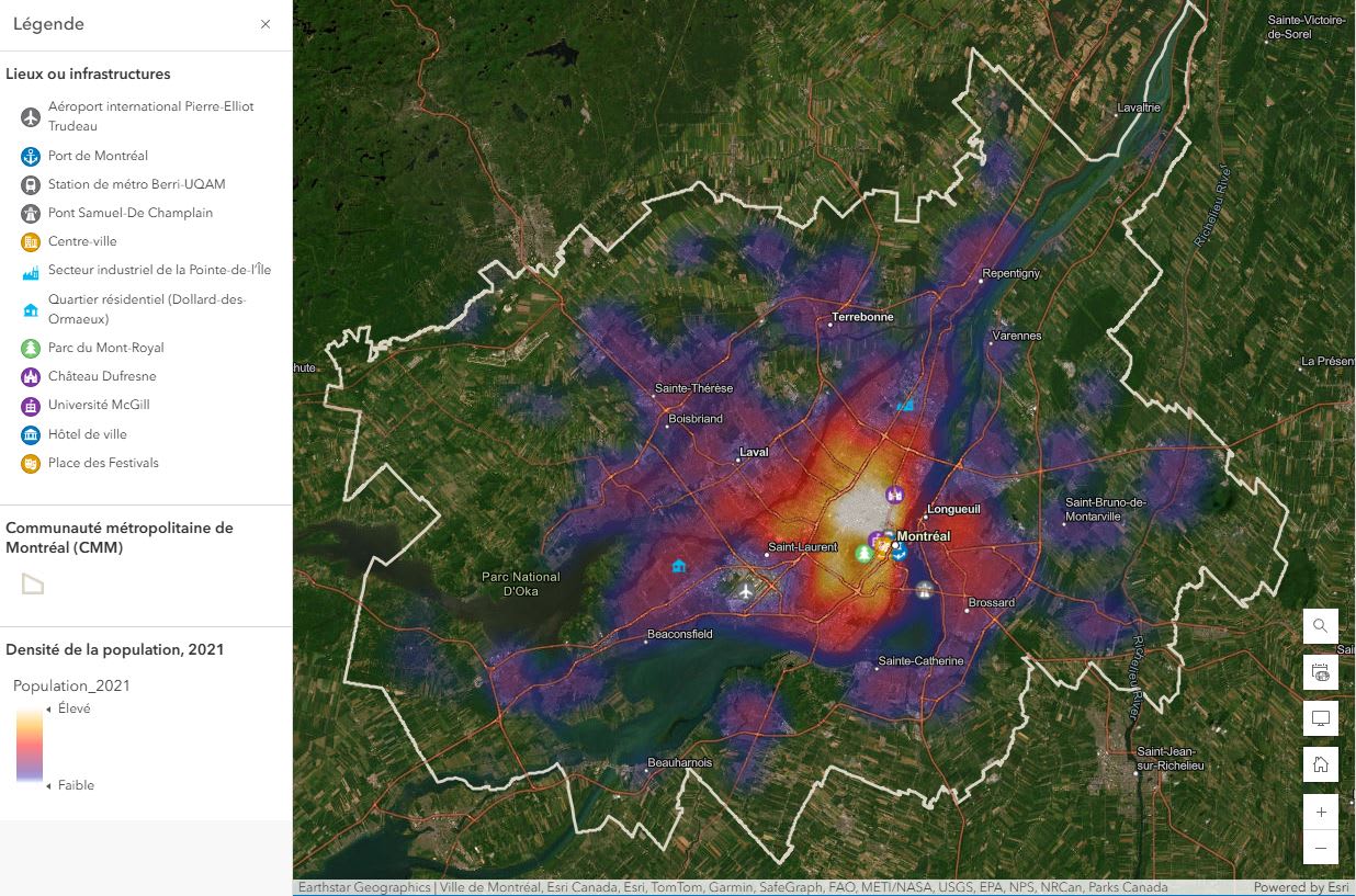
An example of a map the students had to produce
Needless to say, the one-hour workshop was the kick-off to the project, and the students continued to work on their mapmaking project afterwards.
Your toolbox
We are always available to answer your questions, and to guide and support you with your projects. Write to us at k12@esri.ca.
If you’d like to get started on your GIS adventure, visit our website to obtain free access for you and your students: k12.esri.ca.
For more activity ideas and a wide range of resources, visit our K12 Resource Finder.
This post was written in French by Arabelle Sauvé can be viewed here.