Announcing the results of the 2025 ECCE App Challenge
Join us in congratulating the winners of the ECCE App Challenge, Sustainable Foodies from BCIT! This year, teams from the participating colleges and universities across Canada developed apps around the theme of Affordability and Sustainable Economies.
The 11th annual Esri Canada GIS Centres of Excellence (ECCE) App Challenge is complete and the judges have selected the winners.
Every year, students across Canada attending one of the institutions that are part of our Centres of Excellence network have one week to develop an app focused on the given theme. This year, they were challenged to develop their app around the concepts of Affordability and Sustainable Economies. Their week begins with an email revealing the theme, and they have exactly 168 hours, until the same day and time the following week, to complete their app, video, and documentation. Each team has several critical steps to complete:
Pick a topic - The App Challenge theme is designed to have flexibility so teams are more likely to find a subtopic they are passionate about.
Find data - Teams are allowed to use data from any open data source and data they generate themselves.
Plan their user interface and user experience – Teams that take the time to plan before they start building often produce apps that are more user friendly and better aligned with the theme.
Develop and debug their app - This can take various forms, from using the online builders to writing code for a custom app.
Record a sales pitch video - The short video must introduce the topic they chose, their app, and how their app solves the problem.
Write documentation – The team must provide a mission statement and app characteristics to help the user understand the perspective they had while developing their app.
Each ECCE chooses a week during the winter term to run the App Challenge. By mid-April, all the apps have been submitted and judging can begin.
Judging Panel
Judging consists of two rounds. The first round is internal to the Education and Research team to select the top 10 teams that will move on to the second round. The second round has the finalists sent to three judges external to the Education and Research team who then each rank their top three teams. Ideally, the judges will agree on the winners, 1st runners-up, and 2nd runners-up.
This year, our three judges were Paul Salah – Director, Ontario Region at Esri Canada; Mitchell Eastley - GIS Developer/Technician at the City of Steinback, Manitoba; and Nina Baksh - Information Technology and GIS Supervisor at the City of Campbell River, British Columbia. I would like to thank our judges for their time and effort in what ended up being a very hard decision.

Paul Salah – Director, Ontario Region at Esri Canada
Paul Salah is a Regional Director with Esri Canada who provides leadership for sales and services in Ontario. His focus is on helping customers and partners leverage geography and the ArcGIS system to enhance outcomes with location intelligence. Paul has worked as a GIS professional for over 30 years, helping organizations implement Esri technology and integrate with the global Esri community.

Mitchell Eastley – GIS Developer/Technician at the City of Steinback, Manitoba
Mitchell Eastley grew up on a farm outside of Wawanesa, Man. His interest in geography and computers led him to complete his Diploma in GIS Environmental Technologies at Assiniboine Community College in Brandon, Manitoba and a post-diploma Bachelor of Science with a concentration in GIS from the University of Lethbridge. After graduating from the UofL, he joined the City of Steinbach as their GIS Developer/Technician in December 2007 and has built and maintained numerous GIS applications to aid in the City’s day-to-day operations as one of Canada’s fastest growing cities.

Nina Baksh – Information Technology and GIS Supervisor at the City of Campbell River, British Columbia
Nina Baksh is the Information Technology and GIS Supervisor for the City of Campbell River, located on Vancouver Island, British Columbia. She holds a bachelor’s degree in Geography from McMaster University, a post-graduate advanced technology diploma from the College of New Caledonia (Prince George), and a Master’s degree in Geographic Information Science from Birkbeck College, University of London. Nina began her GIS career working with command-line ArcInfo and still occasionally reminisces about those AML days. With extensive experience in municipal IT and geospatial systems, she is passionate about using GIS to improve community services and decision-making.
2025 ECCE App Challenge Results
Congratulations to all the teams who participated this year. As I noted above, it was a difficult decision for the judges.
The 2nd runners-up are SolutionsForUs from Simon Fraser University. Their app MetroWage calculated the living wage required for various family types living in the cities of Metro Vancouver. The 1st runners-up are team GigaBites from the British Columbia Institute of Technology (BCIT). Their app FairBite aims to address food accessibility, availability, and affordability in the neighbourhoods of the City of Vancouver.
Please give a big congratulations to the winners of the 2025 ECCE App Challenge, from BCIT:
The Sustainable Foodies created Nourish Surrey, an app focusing on finding low-cost or free food resources within the City of Surrey. Their Food Finder tab provides tools such as walk-times and nearby transit options to help the user find and access sources of food. It also has filters by day to see when the various resources are available. Their Food Accessibility Dashboard tab displays the Food Accessibility Index they developed, which weights the low-income index and the population density index from Statistics Canada. This tab can support activism and decision makers in ensuring everyone in need is supported.
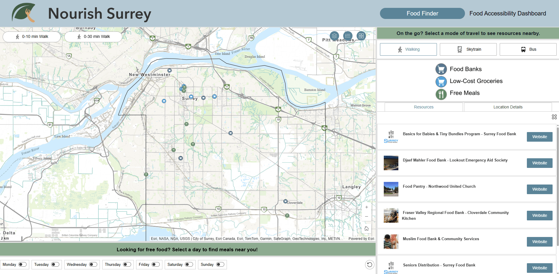
Screenshot of Sustainable Foodies’ app, Nourish Surrey
Congratulations again to the winners and to all the participants! If you are a student at one of our ECCE institutions and you want to compete next year, reach out to the ECCE director at your institution. You may also want to speak to them about how you might become one of the ECCE Student Associates at your institution. The Student Associates are a group of particularly exceptional students involved in GIS research and/or development. They gain access to resources including instructor-led training from Esri Canada, personalized technical assistance from Esri Canada Education and Research staff, and other benefits to help them continue developing their skills and further their GIS research. To learn more about ECCE Student Associates and the ECCE program, visit ecce.esri.ca.