What Canadian water utilities can learn from EPCOR's GIS evolution
EPCOR Utilities Inc., based in Edmonton, Alberta, is a top provider of water, wastewater and natural gas services in Canada and the U.S. This case study explores EPCOR USA’s recent migration to Esri’s ArcGIS Utility Network and the valuable lessons it holds for Canadian water utilities.

ArcGIS Utility Network provides EPCOR USA with a geospatial data management solution that can handle their large, varied and expanding footprint.
Managing Large-Scale Operations-
EPCOR has long leveraged Esri’s advanced GIS solutions to support its operations across multiple regions. EPCOR’s U.S. subsidiary, EPCOR USA, serves over 800,000 people across 44 communities in Arizona, New Mexico and Texas. As the company grew, it became clear that a stronger geospatial data management system was needed. The challenge was to maintain high-quality geospatial services while effectively managing this expansion.-
In 2020, EPCOR USA partnered with Timmons Group, an Esri Network Management Specialty partner, to modernize its GIS platform. The project’s goals were to:-
-
-
- Fully migrate to ArcGIS Pro-
- Retain essential functionality from the previous system-
- Ensure long-term success-
-
-Achieving these goals required a strategic approach that combined advanced technology with a thorough understanding of EPCOR USA's needs. Timmons Group played a crucial role in implementing the ArcGIS Utility Network and upgrading EPCOR USA’s entire ArcGIS Enterprise implementation, setting the stage for a transformative upgrade in the organization’s geospatial management.-
“One of the key questions we face is—how do we continue to deliver high quality geospatial services across an expanding footprint? In other words,-how do we manage scale?” - EPCOR USA-
Solution: Migration strategy and implementation-
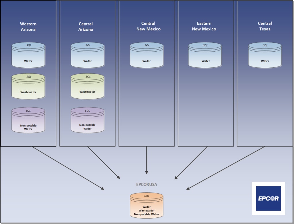
EPCOR’s migration to the ArcGIS Utility Network involved upgrading its entire ArcGIS Enterprise implementation, including Portal for ArcGIS. EPCOR USA needed to manage spatial distortion and align asset records with local tax parcel boundaries. Given the varying geographic regions served by EPCOR USA, the datasets spanned five different coordinate system zones across three states—two in Arizona, two in New Mexico and one in Texas. This complexity required creating nine new Utility Network SQL databases, with a tenth database providing a unified view of the company’s operations.-
Timmons Group delivered ArcGIS Data Reviewer files, allowing EPCOR USA editors to navigate and correct data errors to streamline the migration easily. While not all subnetworks were fully built out initially, this approach brought EPCOR USA significantly closer to achieving full Utility Network functionality.-

EPCOR USA’s ten Utility Network databases across five regions, each with SQL databases for water, wastewater and non-potable water.
Tailoring the solution to meet specific needs-
EPCOR USA’s migration process involved customizing Esri’s water and wastewater data models to fit their specific business needs. The customized data models were consistently applied across all regions, ensuring that EPCOR USA’s vast and varied operations could be managed efficiently.-
Attribute rules were configured to simplify editing tasks, such as populating fields based on intersecting polygons or generating unique IDs. These rules, combined with the Utility Network’s connectivity rules, enhanced data quality and streamlined workflows.-

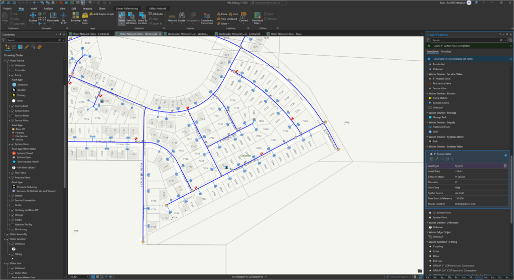
ArcGIS Utility Network editing templates streamline water utility data management in a neighborhood.
EPCOR USA also focused on enhancing user experience by configuring group editing templates and integrating the new editing tools into their Portal for ArcGIS environment. This allowed EPCOR USA to push updates across the organization easily, ensuring all editors were working with the latest tools and templates.-
Results--
EPCOR USA’s Cityworks asset management system (AMS) implementation was a critical downstream component of the project. EPCOR USA maintained asset configuration and work history in Cityworks by aligning the Texas data model with other water systems. The transition to the new GIS schema was smooth, with minimal user disruption, thanks to thorough planning and iterative testing. The implementation of the Utility Network provided significant business benefits, particularly for field operations, including:-
-
-
- More efficient editing workflows-
- Cleaner datasets with improved quality control-
- Easier sharing of GIS content-
-
The culmination of this project saw EPCOR USA’s GIS team develop a new mapping application using ArcGIS Web AppBuilder. It replaced the old third-party system and provided a more unified, efficient and user-friendly way for employees across the organization to access Utility Network data.-
In essence, the transition to an internally developed system allowed for better integration of data and tools, improving the overall user experience and making it easier for different departments to access and work with the data.-
Conclusion-
The successful migration to the Utility Network has positioned EPCOR USA to remain at the forefront of geospatial technology. The modernization of their asset register now delivers efficiency and effectiveness improvements downstream in other business systems, such as their enterprise asset management system. For Canadian water utilities, EPCOR USA’s approach offers valuable insights into managing GIS migrations, ensuring long-term success and leveraging modern geospatial tools to enhance operations.-

- Plan your GIS migration thoroughly: Detailed planning and a clear understanding of business requirements lead to a smoother transition.-
For Canadian water utilities, involving key departments is crucial for a successful GIS migration. Recommended departments include:-- Operations and Maintenance: To ensure workflows align with field operations and asset management needs.-
- IT Department: To handle technical aspects, integration and support for new software and systems.-
- Engineering: To provide input on infrastructure and asset configuration needs.-
- Customer Service: To ensure the migration enhances service delivery and data accessibility for end-users.-
- Finance: To assess budgetary requirements and long-term cost-effectiveness.-
- GIS/Mapping: To manage the technical details of the migration and ensure data accuracy.-
- Customize and standardize data models: Tailor data models to department-specific needs while maintaining consistency to boost efficiency and accuracy. Specific jobs to be done include maintenance programs, preventive maintenance, predictive maintenance with IoT sensors or asset management lifecycle planning.-
- Harness modern technology in Canada: Use advanced tools like ArcGIS Pro and Utility Network to streamline data management and improve workflows.-
Customers can expect time savings through faster data access, reduced manual data entry and improved collaboration across departments. For example, when a field crew in the City of Brandon, MB closes a valve for maintenance, all users can see the update immediately, leading to more proactive communication with affected residents and ultimately improving operational efficiency.--
By adopting these lessons, Canadian water utilities can enhance operational efficiency, improve customer communication and ultimately ensure the reliability and safety of our water systems.-
Questions? Find answers at esri.ca/water-
Learn more about Utility Network management.-
References
Migrating at Scale: A Ten-Database Utility Network Case Study
EPCOR – Utility Network Implementation & Cityworks Reconfiguration