Edmundston improves efficiency and service delivery with Cityworks
The City of Edmundston’s public works and energy teams faced operational delays from disconnected systems. Their new integrated approach now keeps operations running smoothly, improving efficiency, coordination and response times. Find out what made the difference.
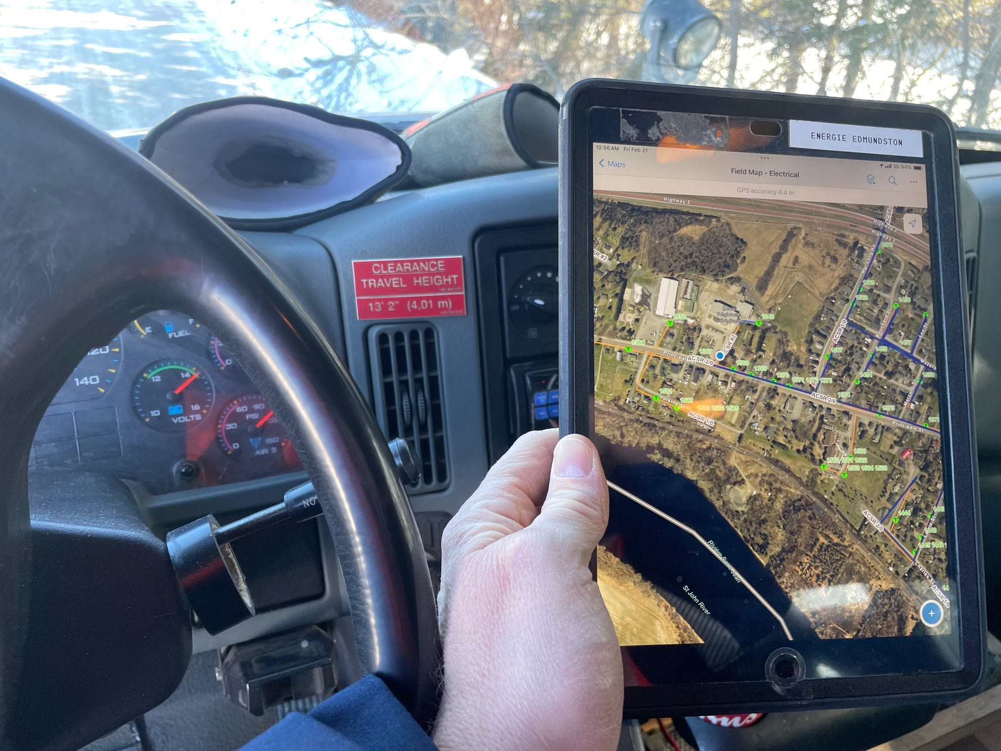
Edmundston public works team on the road using ArcGIS Field Maps for electrical operations.
Municipalities rely on efficient service delivery to meet the needs of residents, businesses and infrastructure. However, outdated processes and disconnected systems can create operational challenges, delaying response times and making data management difficult.
The City of Edmundston, NB, tackled these challenges with a strategic move towards digital transformation. Home to 18,500 residents, Edmundston is a regional hub that sits at the confluence of the Saint John and Madawaska Rivers, bordering Maine and Québec. With over 200 employees managing key municipal services, the City integrated a geographic information system (GIS) and Trimble Cityworks to improve asset and maintenance management, community engagement, inventory management, and service response times.
Challenges before Cityworks
Prior to implementing Cityworks, Edmundston relied on a mix of paper-based and digital processes. While some departments had well-defined workflows, others operated in silos, resulting in inefficiencies such as:
- Multiple disconnected systems requiring separate logins, licenses and training
- Extensive IT infrastructure demands supporting various applications
- Lack of mobile connectivity, limiting field operations and involving rework
- Custom interfaces to enable or facilitate system interoperability
The absence of a secure, unified system led the City to find a GIS-based solution.
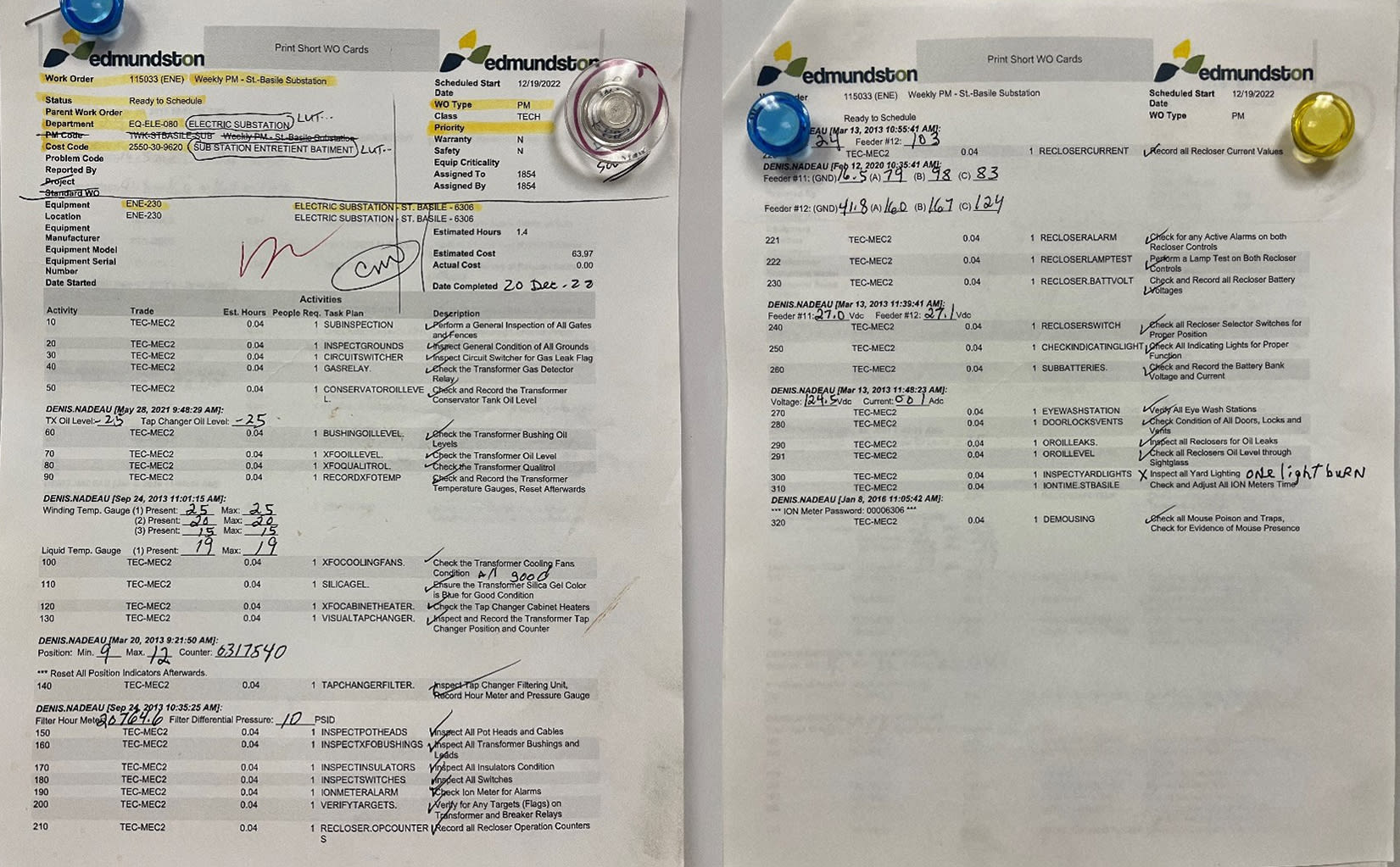
Printed work orders from 2022, previously used in a disconnected system, where paper records were later manually entered into the CMMS.
Solution: A phased approach to GIS & CMMS integration
To enhance operations and improve asset management, the City adopted GIS technology in 2010, followed by a Computerized Maintenance Management System (CMMS) to streamline workflows and work orders. This integration centralized data and addressed the challenges of disconnected systems. The City’s timeline included:
1. Laying the foundation
Edmundston initiated an asset management transformation by implementing a GIS with a Spatial Database Engine (SDE), covering water, sanitary, storm, fleet and electric utility. Simultaneously, a CMMS was introduced for work order and inventory management. This included non-spatial assets in electric distribution and generation, as well as fleet and other assets, laying the groundwork for a more integrated approach. Another service request management system was deployed in parallel to streamline and digitize the problem intake and resolution process.
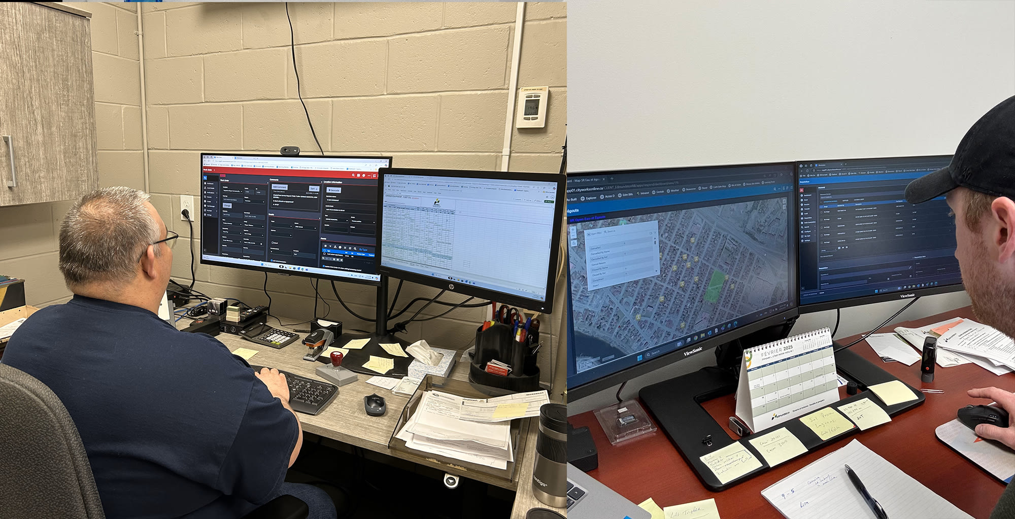
L: Alain St-Onge, Edmundston Mechanic foreman | R: Justin Connely, Edmundston Water & sewer coordinator
2. Expanding capabilities
After a GIS architecture evaluation, the City expanded from an SDE to ArcGIS Online, now including asset groups for electric distribution, transportation, facilities and public works networks. This upgrade enhanced asset mapping, with a strong focus on managing GIS asset data such as condition, replacement costs, risk and lifespan attributes. In 2021, Edmundston built a business case to fully integrate GIS with CMMS, enhancing system interoperability and streamlining asset management. The plan also aimed to consolidate other existing systems into Cityworks.
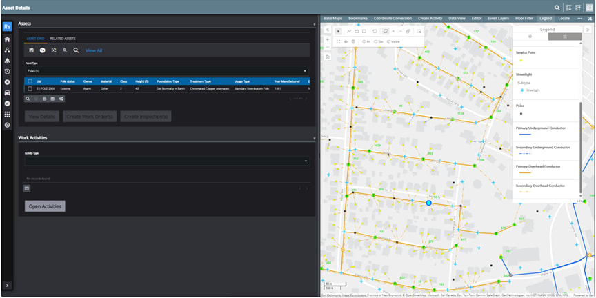
Electric distribution GIS network asset mapping; selecting assets from the map (right panel) and creating work activities on selected assets (left panel).
3. Cityworks transition
With a strong GIS foundation, Edmundston launched Cityworks AMS in spring 2022, modernizing asset, work order, asset inspections and service request management. Key steps included planning a deployment strategy, migrating active work orders, service requests, inventory and storerooms, and configuring work order and service request templates. Cityworks was also integrated with their fleet fueling system and indirectly with their financial systems, enhancing transparency, process flow and reducing duplicate data entry.

Mathieu Godbout, Energy service, Planning and analysis coordinator, on site reviewing a maintenance work order on a tablet in the winter.
"With Cityworks, we’ve streamlined our response and maintenance processes. Field crews can now update work orders and services requests in real time, cutting delays and improving service delivery."
— Daniel Arsenault, Strategic management coordinator, City of Edmundston, NB
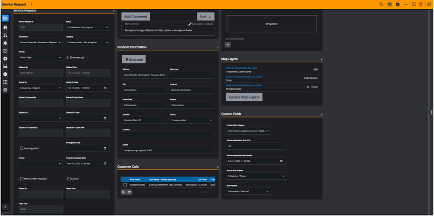
Service request for hydrant maintenance using GIS layers to display water treatment zones, pressure zones, and expected PSI, helping workers prepare and accelerate new staff training.
Results: Measurable gains in response and service delivery
Since implementing Cityworks, Edmundston is continuously streamlining operations, now managing up to 500 service requests and 400 work orders monthly across all nine city services. These include energy, public works, transportation, water and sanitary, garage and fleet, facilities management, police, fire and others. Internal Cityworks Respond dashboards and Esri ArcGIS Dashboards prioritize tasks and aid in work assignments and scheduling. Labour and asset costs are tracked within targeted activities and service levels.
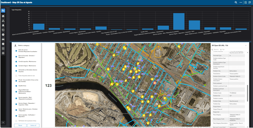
Public works water utility dashboard with all active service requests and an embedded ‘EURL service' for interactive mapping by request type.
Field crews are now able to update work orders and service requests in real time using Cityworks Mobile apps for iOS and Android, improving response times. The City has also integrated monthly garage re-billing services, which track fleet maintenance and repair costs, indirectly with their financial system.
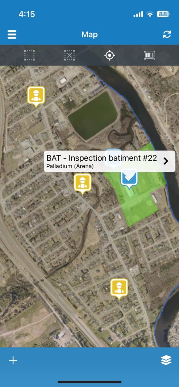
Cityworks Mobile (V11) maps assign tasks in real time, helping crews identify nearby activities for efficient fieldwork.
Benefits of implementing Cityworks
Since implementing Cityworks, Edmundston has achieved significant improvements in operational efficiency and service delivery. Some notable benefits include:
- Enhanced data transparency: A centralized system ensures that asset data is up-to-date and accessible across departments.
- Improved efficiency: Mobile access allows field crews to receive and update work orders, service requests and inspections in real time, reducing delays.
- Cost tracking & productivity insights: The ability to monitor activities, costs and workforce productivity to support better decision-making.
- Citizen engagement: The introduction of a self-service portal enables residents to submit service requests and track their status.
- Seamless integration: Cityworks’ compatibility with GIS ensures that asset conditions, risks and maintenance histories are easily retrievable and editable from the Cityworks environment.
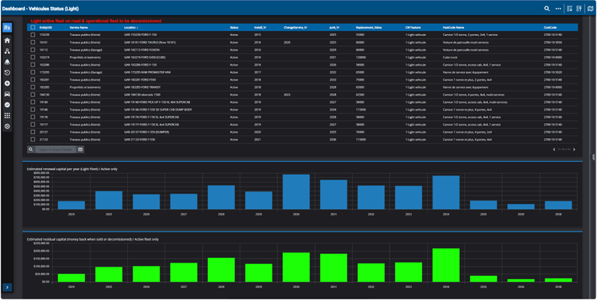
Dashboard used to forecast capital asset renewal for light fleets.
Lessons learned: A model for other municipalities
Edmundston’s phased Cityworks implementation highlights key takeaways for modernizing asset and work management:
- Invest in GIS early and align it with CMMS needs
- Build a strong asset management foundation
- Foster stakeholder collaboration and training
- Leverage integrations to maximize capabilities
With a strategic approach, municipalities can streamline operations, enhance service delivery and make data-driven decisions that benefit both staff and residents. Embracing digital solutions like Cityworks and GIS helps build smarter, more connected communities.
What’s next?
Edmundston is enhancing its use of Cityworks with a strategic plan to build a secure, connected and centralized system accessible anywhere. The City will expand to new asset groups, including stormwater, parks & recreation and fiber optics network. They plan to explore integrating their fleet AVL system with Cityworks to trigger automatic work activities from vehicle sensors with information like mileage and engine hours ran. Edmundston is also exploring implementing a process flow for equipment asset swapping of electric and water meters and distribution transformers.
Let’s hear your story!
Have you used GIS or a partner solution to solve a challenge or improve your organization? We would love to showcase your success and inspire others. Share your experience and contribute to industry knowledge with a GIS Success Story.
Questions? Contact us at esri.ca/publicworks
Learn how public works departments strengthen asset management and optimize decision-making with GIS: resources.esri.ca/public-works. Reach out to-Christopher Roth, Industry Manager, Public Works.
For a deeper dive into their integrated approach to measurable gains, learn from Edmundston’s 2024 Cityworks Virtual Forum presentation with Daniel Arsenault.