A mid-sized county digitally transforms its property management workflows
Over the last year the County of Lennox and Addington has revolutionized their property maintenance and management workflows, transitioning from relying on paper forms, emails and phone calls, to a streamlined process built on top of the ArcGIS platform. Read more to learn about the County’s Work Order and Record Keeping (WORKS) system, which was recently recognized at the Urban and Regional Information Systems Association (URISA) Ontario Chapter AGM with a silver award for ‘Innovation in Municipal GIS’.
The County of Lennox and Addington is located in eastern Ontario and stretches from Lake Ontario to the rugged, rocky terrain of the Canadian Shield. Its neighbors include Renfrew, Hastings, Prince Edward and Frontenac counties.
With a portfolio spanning 25 properties, including numerous offices and over 400 housing units across the region, there’s never a dull moment for the County’s property management team. From regular and irregular unit inspections and repairs, to grass cutting, snow removal and smoke detector inspections, work orders were traditionally managed by relying on paper forms, emails and numerous “where are you and what are you doing?” phone calls throughout the day.
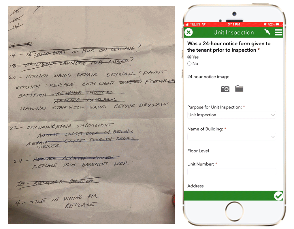
Before and after WORKS
Planning for transition
When the Property Services department approached the County’s IT Department less than two years ago, staff quickly identified an opportunity to leverage the full potential of the County’s ArcGIS technology.
“Looking into our existing Enterprise license with Esri Canada, we immediately saw that it would be advantageous to further leverage a platform adopted by our organization” says Nathan Bruce, the County’s GIS Analyst. “We started by reaching out to our regional municipal peers and also had extensive discussions with Esri Canada, seeking insight on similar deployments regionally and nationally.”
GIS staff also went through an extensive learning process, shadowing field staff and gathering business requirements. Since the 25 staff members from the property management team had no previous GIS experience, engaging them from the start was crucial to the success of this project. Some users were initially skeptical, concerned with being tied to their phones all day to document their work. However, the tight collaboration and early walk-throughs quickly revealed the benefits of user-friendly digital forms, streamlined communication between office and field, and the ability to record and be recognized for work completed.
Building the solution
Developing a solution that would work for the County’s unique needs could not be accomplished with a one-size-fits-all approach. Different use-cases and business needs required a lot of flexibility and the ability to integrate various ArcGIS apps in a modular way.
The team now uses Workforce for ArcGIS (Workforce) to schedule work orders in the office and coordinate field work. “Workforce really brings it all together,” says Matthew Mulder, the County’s GIS Technician, “allowing us to optimize allocation of work and view real-time status of work and field staff locations.”
Dispatcher view (large display) and mobile workers view (smaller display) of Workforce assignments
“Then, the flexibility of the Survey123 (for ArcGIS) app allowed us to build in logic and complexity to address basically any inspection or work order you can think of,” adds Matthew. With more than 80 different types of work orders, the team uses Survey123 extensively to design user-friendly and logic-driven smart forms to record inspections and repairs, as well as for triggering real-time notifications using Survey123 webhooks.
Digital smart forms developed for generating 24 different work orders types
Staff also use Collector for ArcGIS to capture maintenance information in ad-hoc scenarios, where a strict dispatcher-field worker model is not required. On top of that, with over 20 Operations Dashboard for ArcGIS applications developed, including large screen displays for at-glance operational awareness and business intelligence, the team has been called out for liking Operations Dashboard just a little too much. Dashboards are used by a variety of staff and support different workflows. Staff can drill down into daily workload management or gain spatial and temporal insights on maintenance and repair trends.
By combining the different apps, the county is leveraging the technology to its fullest. From the end-user’s perspective, the different apps seamlessly integrate and provide a simple and easy-to-use experience.
Operations Dashboard for ArcGIS showing real-time status and statistics of work performed. “This is phenomenal! If anyone would have told me 30 years ago, that I would have a 65” TV in my office, showing me all of this, I would have said ‘ you’re crazy!’” - Ken Beattie, Property Services Manager.
The road ahead
The County’s GIS team is excited to explore future improvements and enhancements to keep up with new AGOL capabilities. Some of these are focused on expanding WORKS capabilities and capture requests from other internal staff, perhaps externally from tenants. Others are on the governance side, such as improving documentation and developing a strategy for data depreciation and storage.
The success of the program and the ability to transform organizational knowledge into numbers and statistics have brought much attention to the central role of GIS as an enabler and driver for digital transformation across the organization. The County is now looking into opportunities to expand and replicate these workflows with other departments, further leveraging the County’s investment in the ArcGIS Online platform to achieve similar efficiencies.
If you want to reach out to the County of Lennox and Addington, please visit their contact page here.
If you want to learn more about how Esri Canada can assist you with building a similar solution, you can visit our Workforce Starter Solution web page here.