Transport Canada's Enterprise GIS: A Blueprint for Federal Modernization
Transport Canada has evolved its GIS from standalone tools into a secure, cloud-first enterprise platform. This blog shows how that shift is strengthening coordination, accelerating insight and setting a model for federal modernization.
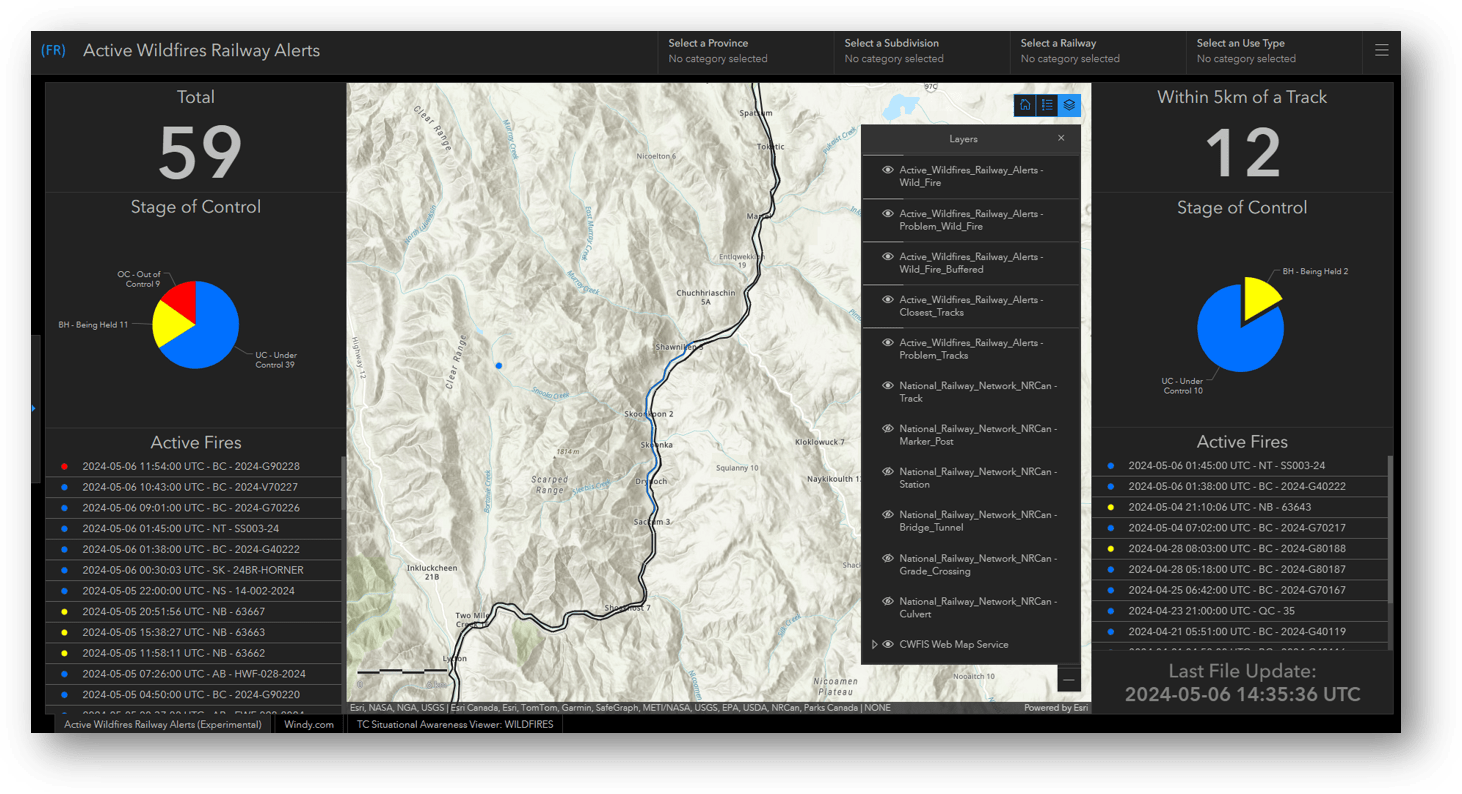 Real-time wildfire alerts help Transport Canada monitor risks near rail infrastructure, enabling faster, data-driven decisions to ensure safe operations.
Canada’s transportation system is vast, intermodal and increasingly data-driven. Over the past few years, Transport Canada (TC) has been modernizing the way it turns geospatial data into decisions — evolving from isolated tools to a cloud-first enterprise GIS that reliably serves analysts, inspectors, policy teams and partners across the country. Today, TC’s eGIS operates on a Protected B Azure environment, positioning the department to scale securely while integrating with adjacent enterprise data platforms.
“Transport Canada’s GIS journey began with ArcGIS Online and evolved into a secure cloud-hosted ArcGIS Enterprise platform at a time when the department’s cloud infrastructure itself was still being established [...] Today, operating in the cloud provides significant advantages in terms of scalability, robustness, security and the ability to integrate with enterprise data platforms that support data hosting, pipelines and advanced analytics. This evolution has positioned the team to deliver geospatial services more reliably and at the pace required to support modern transportation programs.”
— Alvaro Faria, Data Visualization Report Development Team Leader, Transport Canada
Maintaining a transportation system that is safe, secure, efficient and resilient has become increasingly complex as supply chains evolve, climate pressures intensify and arctic mobility takes on heightened strategic importance. Recent federal commitments, including major funding for trade corridors and new investment in the Arctic Infrastructure Fund, underscore the growing need for integrated, data-driven visibility across modes, regions and partner organizations. In this environment, geospatial infrastructure is no longer simply a technical enabler but a coordinating system that supports operational oversight, regulatory decision-making, program alignment and strategic planning.
The department’s mandate now requires faster insight cycles, greater interdepartmental collaboration and a more comprehensive understanding of how local operational issues scale to national impact. Enterprise GIS provides one of the only frameworks capable of meeting these demands at speed and at the scale required for modern transportation governance.
Transport Canada’s enterprise GIS supports multimodal transportation insights, connecting rail, air and marine data to enable smarter, coordinated decision-making.
From Tools to an Enterprise Platform
Transport Canada’s shift from standalone geospatial tools to a cloud-based enterprise platform has fundamentally changed how the department manages and applies data. The Protected B ArcGIS Enterprise environment now serves as a stable, centralized foundation for authoritative geospatial services and enterprise-wide data stewardship. This approach ensures that data supporting oversight, regulatory functions and national transportation programs is both secure and consistently available to the users who rely on it.
This modernized foundation has also enabled more advanced analytical work. Power users in groups such as Economic Analysis, Emergency Management and Transportation of Dangerous Goods increasingly rely on analytics and dashboards that allow them to interpret conditions, assess risks and communicate insights more efficiently. For example, Emergency Management leverages ArcGIS Dashboards built on eGIS to provide near real-time operational context during events, enabling executives to make more timely, informed decisions.
“Every year, wildfires threaten transportation infrastructure, causing slowdowns, disrupting supply chains, and sometimes resulting in significant damage that requires long recovery periods. In the past, regional emergency managers manually reviewed long, constantly changing lists of wildfires and located each one to determine proximity to railway tracks. Today, automated data pipelines from fire agencies trigger advisory alerts whenever a new wildfire is reported within 5 km of rail infrastructure, with information summarized in a dashboard and automatically delivered to emergency managers and railway inspectors. This near–real-time situational awareness enables inspectors to quickly implement mitigation measures, such as speed restrictions, to ensure safe railway operations. Manual effort is eliminated and situational awareness is instantly provided across the whole organization.”
— Ken Marshall, Manager, Digital Technology, National Security and Intelligence, Transport Canada
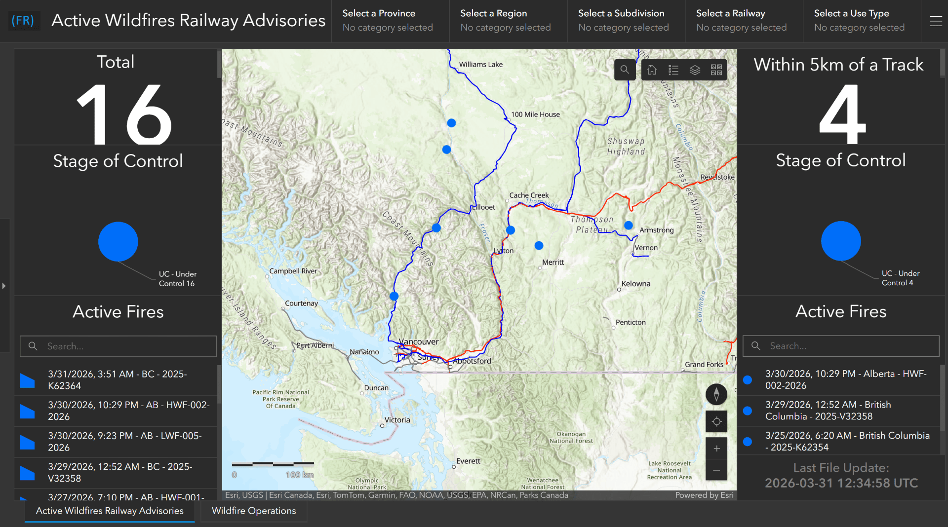
Targeted wildfire advisories help Transport Canada track risks near rail lines, focusing attention on fires that may require operational response.
While TC is not yet deploying mobile GIS at scale, early proof-of-concept work with ArcGIS Field Maps has shown meaningful potential. The department sees future value in equipping inspectors and frontline staff with modern, location-enabled tools that streamline data collection and tie operational observations more directly into enterprise systems. The vision is clear: as Field Maps matures beyond pilot use, TC can further tighten the link between field activity and enterprise insight.
Scaling Adoption Through a Strong Community of Practice
One of the most important contributors to TC’s enterprise GIS maturity has been the continued strengthening of the department’s GIS Community of Practice (CoP). Far from being a supplemental initiative, the CoP has become a central driver of consistency, collaboration and knowledge transfer. Regular sessions bring together analysts, program staff, policy teams and technical specialists from across the department, creating a shared space where emerging ideas can be exchanged and successful practices can be replicated.
A strong CoP also plays a critical role in reducing fragmentation. By exposing teams to common patterns, authoritative datasets and repeatable workflows, the community reduces duplication and helps ensure that new initiatives build on existing investments rather than diverging into isolated or incompatible solutions. It also supports a culture of professional development, giving new users a safe on-ramp into the enterprise GIS ecosystem while offering experienced practitioners a venue to refine and extend their capabilities.
As enterprise GIS continues to expand across the federal landscape, TC’s CoP stands out as an example of how departments can institutionalize geospatial practices and maintain momentum even as teams evolve and priorities shift.
Preparing for the Next Phase: AI-Ready Foundations
The Government of Canada’s AI Strategy for the Federal Public Service calls for secure, transparent and responsible adoption of advanced analytics. Many of these expectations depend on having trustworthy, well-governed and interoperable data. TC’s enterprise GIS directly supports this requirement by providing the governance structures, metadata quality and access controls necessary for AI-enabled workflows to operate responsibly and effectively.
Because Transport Canada has invested in a modern, cloud-based ArcGIS Enterprise environment hosted in Protected B Azure, the department is exceptionally well-positioned to take advantage of Esri’s newest AI capabilities. This foundation enables Esri’s emerging AI Agents to work directly and securely with Microsoft AI Agents deployed in the same cloud ecosystem, allowing geospatial context to flow naturally into AI-assisted reasoning, summarization and decision-support. As Esri and Microsoft continue to deepen integration between their AI stacks, TC’s existing architecture provides the ideal environment for connecting enterprise geospatial services with advanced natural-language interfaces, automated analysis routines and cross-platform AI workflows.
As federal priorities expand around multimodal corridor performance, northern resilience and environmental adaptation, the ability to integrate geospatial context into AI models will play an increasingly central role in how the department forecasts risk, allocates resources and evaluates options.
A Model for Other Federal Departments
Transport Canada’s experience demonstrates that enterprise GIS modernization is not simply about implementing a platform — it is about aligning technology, governance, analytics and organizational culture to support mission needs. Departments facing complex mandates, distributed operations or growing demands for data-driven decision-making can learn from TC’s approach. The combination of a secure cloud foundation, authoritative enterprise services, cross-program analytics, early field mobility exploration and a strong Community of Practice provides a proven blueprint for scalable modernization. As the transportation system continues to evolve, TC’s enterprise approach ensures it can respond with greater agility, clarity and coordination — strengthening its ability to deliver greater value to Canadians.