Edmonton Police Service leads creation of enhanced community safety system
Federal program grants $1.3 million to Edmonton Police Service and Esri Canada for partnership focused on making transit safer
EDMONTON— October 30, 2025—Edmonton Police Service, along with its partner Esri Canada, was selected as the Canadian agency to lead the development of a next-generation community safety system, powered by Esri’s comprehensive geographic information system (GIS) platform ArcGIS. This innovative partnership was awarded $1.3 million in federal grant funding to develop the Edmonton Transit Enhanced Community Safety System (ETECS), a pioneering project that will support critical enhancements in officer security and community safety in transit environments in Edmonton and across Canada.
“Everyone deserves a safe and secure transit journey,” says Ron Anderson, Chief Innovation and Technology Officer, Edmonton Police Service. “With ETECS, we’re leveraging advanced mapping, indoor positioning systems and real-time analytics to transform the ability of our police resources to monitor, plan and respond to incidents, enhancing community safety throughout our transit network.”
The ETECS solution demonstrates improved officer safety and security within the Edmonton Churchill LRT station by creating a digital twin, which allows officers to conduct a 3D walkthrough of the underground station and surrounding pedestrian walkways. The system also provides officers with location tracking and wayfinding capabilities using Esri’s digital indoor mapping software, ArcGIS Indoors. Officers can quickly locate themselves and others inside a building or underground in real time through Esri’s indoor positioning system, ArcGIS IPS. They can also view various data including real-time officer locations and video feeds through dynamic dashboards—improving situational awareness and informing transit policies and community safety measures.
“Knowing what’s happening and where officers are located at any given point in time - above ground and underground, in real time makes a huge difference in public safety,” says Joann Fox, director, Public Safety, Esri Canada. “Today’s GIS technology provides powerful capabilities to visualize and analyze live data feeds from various sensors, devices and systems and share reliable insights to frontline officers. The work we’re doing on the ETECS project will help Edmonton and many other municipalities across the country strengthen transit safety.”
The ETECS project is supported by the Canadian Safety and Security Program; a federal program led by Defence Research and Development Canada’s Centre for Security Science, in partnership with Public Safety Canada.
See the presentation “ETECS: Real-Time Indoor GIS for Urban Transit” on Tuesday, November 4 at the Esri Canada User Conference, being held in Toronto on November 3-4, 2025.
About Edmonton Police Service
Edmonton is a growing city with a diverse population. As a modern police service committed to increasing community safety, EPS balances traditional enforcement with social needs by establishing strong community partnerships, leveraging data-driven evidence and cultivating an innovative workforce reflective of the city it serves. More information can be found at edmontonpolice.ca
About Esri Canada
Founded in 1984, Esri Canada provides geographic information system (GIS) solutions that empower people in business, government, and education to make informed and timely decisions by leveraging the power of mapping and spatial analytics. These solutions enable organizations to better manage their resources, plan their future and collaborate within and beyond their organization. Esri Canada’s products and services help advance successful digital transformation. The company serves more than 14,000 organizations from 13 offices across Canada and is based in Toronto. Esri Canada has been recognized as one of Canada’s Best Managed Companies for 13 consecutive years. More information can be found at esri.ca. Follow Esri Canada on X (Twitter), Facebook, YouTube, Instagram and LinkedIn.
About Defence Research and Development Canada
Defence Research and Development Canada (DRDC) is Canada's science, technology and innovation leader, trusted advisor, collaborative partner, and knowledge integrator for defence and security. As the science and technology organization of the Department of National Defence (DND), DRDC develops and delivers new technical solutions and advice to DND, the Canadian Armed Forces, other federal departments, and the safety and security communities. DRDC also works with partners in academia, government and industry and with Canada’s allies.
Media Contacts:
Edmonton Police Service
mediarelations@edmontonpolice.ca
Esri Canada
press@esri.ca
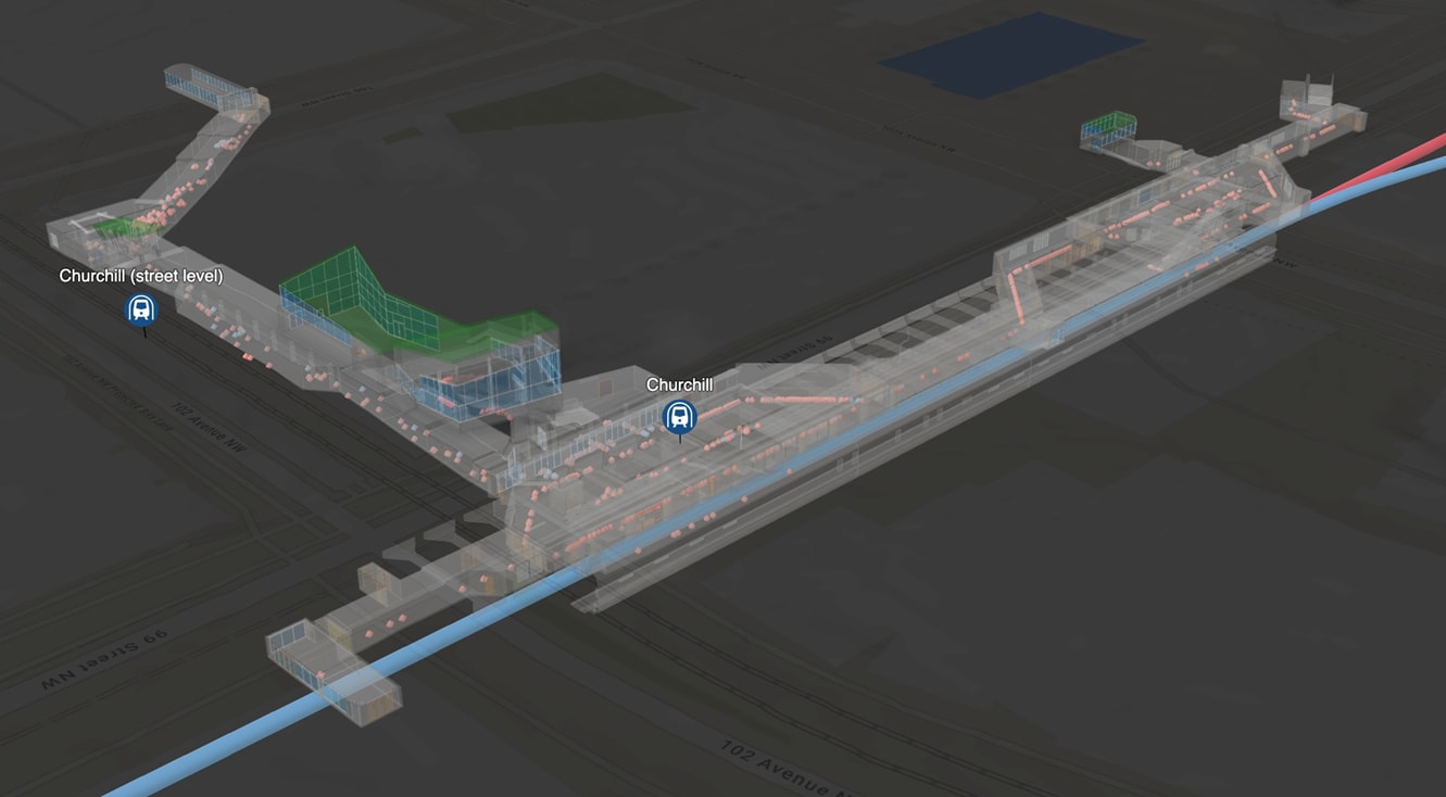
A digital twin of the Churchill station in Edmonton showing recorded positions to support officer tracking and wayfinding within the underground LRT system