How to Use ArcGIS for Smart Campus Planning and Management
In today’s dynamic educational landscape, colleges and universities face the challenge of managing sprawling campuses efficiently while providing a safe and enriching environment for students and staff. This post highlights examples of how higher education institutions are using ArcGIS Enterprise along with other Esri products to streamline operations, enhance safety, and foster collaborative environments.
ArcGIS Enterprise is a comprehensive GIS platform, available both on-premises and in the cloud, that provides robust tools for spatial analysis, data management, and 2D and 3D visualization. It has emerged as a powerful tool for smart campus planning and management. By integrating diverse datasets, including BIM and CAD, ArcGIS Enterprise creates a Digital Twin of the campus—a unified system that facilitates informed decision-making, improves collaboration among stakeholders, and supports efficient management of campus assets and environments. Additionally, the ability to store all information in a centralized, secure platform ensures data consistency, accessibility, and reliability, ultimately driving smarter campus operations and sustainability initiatives.
ArcGIS Enterprise consists of several key components that can be deployed either on-premises, giving institutions full control over their data and infrastructure, or in the cloud, providing scalability and flexibility. These different deployment options allow higher education institutions to tailor their GIS infrastructure to meet specific needs and security requirements, ensure seamless integration with other campus management systems and foster a collaborative, data-driven environment for efficient campus operations. To learn more about ArcGIS Enterprise and all its components you can read this blog post.
ArcGIS Online, a software-as-a-service (SaaS) hosted and managed by Esri, offers cloud-based ready-to-use GIS services and apps that are comparable to ArcGIS Enterprise services but differ in several ways. Additionally, ArcGIS Enterprise and ArcGIS Online can be used together by implementing a distributed collaboration that allows users to share layers, maps, and other data between systems. This approach makes data more accessible across an entire organization and enables workflows such as managing data in ArcGIS Enterprise and sharing it with the public through ArcGIS Online.
Watch the video below to see examples of smart campus management in action. Keep reading to gain deeper insights into the Esri technologies used to optimize campus operations.
Streamlining Campus Planning and Management with ArcGIS Enterprise/Online
Universities use ArcGIS Enterprise together with ArcGIS Online to host, share, analyze and visualize campus infrastructure, land use, and transportation networks. For instance, Portal for ArcGIS can be used to provide access to ArcGIS Pro, which campus planners can use to create detailed 2D or 3D models of campus buildings and landscapes for optimizing space utilization, planning new construction projects, and improving campus accessibility. The models can then be published to ArcGIS Enterprise and used in web maps, scenes, and apps built with ArcGIS Experience Builder, other low-code/no-code app builders or ArcGIS Maps SDKs.
Case Study: University of Saskatchewan
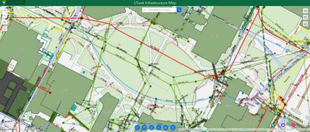
University of Saskatchewan Campus Infrastructure Management Dashboard
Case Study: Western University
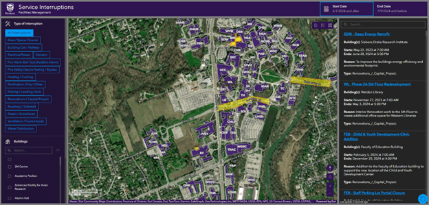
Western University Service Interruption Dashboard
Case Study: University of Washington
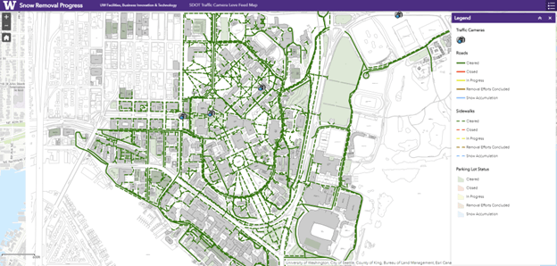
University of Washington Snow Removal Management Application
Enhancing Facilities Management
The integration of BIM and CAD with GIS within ArcGIS Enterprise or ArcGIS Online revolutionizes campus infrastructure management by combining detailed architectural models with geospatial data in a unified platform. This integration enhances planning, design, and decision-making, allowing facility managers to create 3D models, perform spatial analysis, and visualize building information geographically. Esri's collaboration with Autodesk places GIS and BIM integration at the forefront of AEC (Architecture, Engineering, and Construction) projects, driving digital transformation for a more sustainable, resilient future.
Case Study: Toronto Metropolitan University
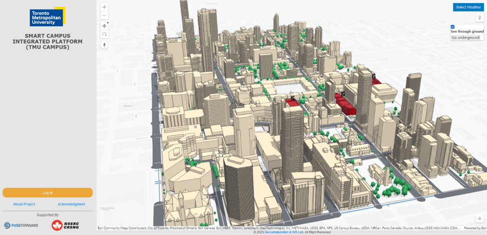
TMU’s Smart Campus Integrated Platform
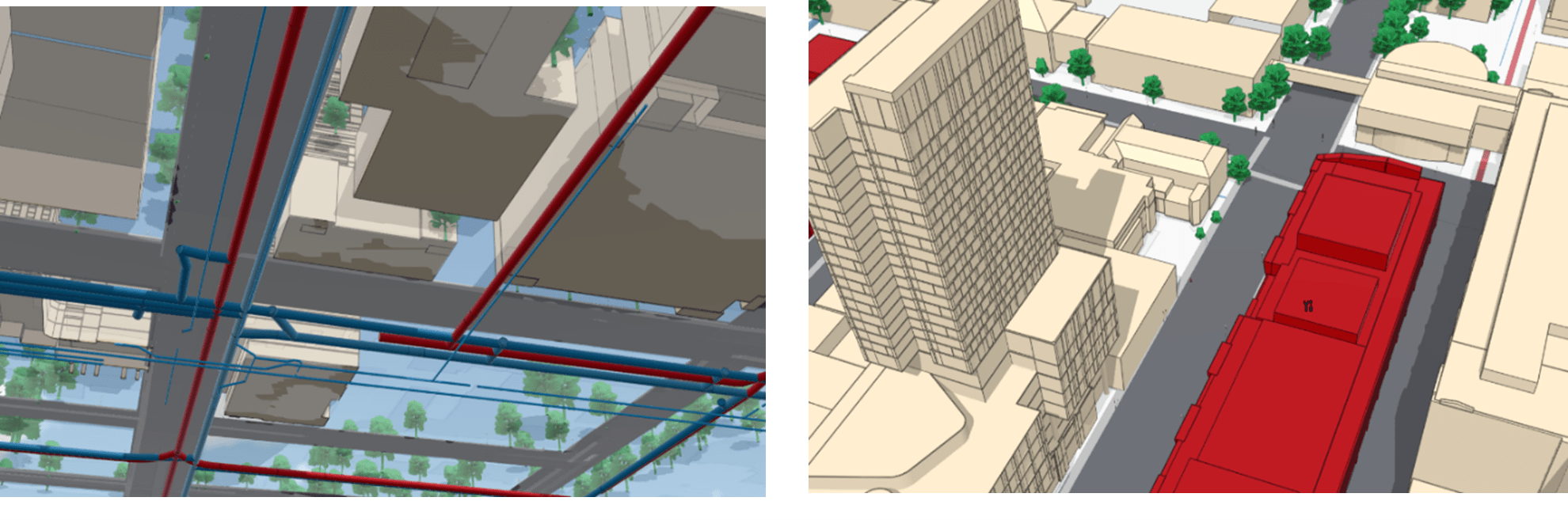
GIS Used to Manage Campus Utility Networks and Building Maintenance of Toronto Metropolitan University (TMU)
Case Study: Fanshawe College
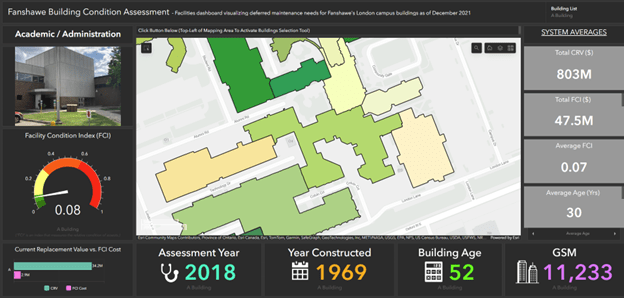
Fanshawe College Building Condition Assessment Dashboard
Ensuring Campus Safety and Public Security
Safety and security are paramount in university settings. ArcGIS Enterprise supports campus security teams by enabling real-time crime mapping, risk assessment, and emergency response planning. Dashboards can be used to provide a real-time operational view of campus security, allowing administrators to monitor incidents and deploy resources efficiently.
Case Studies: University of Denver and University of Iowa
Advancing Sustainability with GIS
Sustainability is a key focus for many universities as they strive to reduce their environmental footprint and promote green practices. GIS technology plays a vital role in advancing sustainability initiatives on campus. ArcGIS Enterprise can be connected with other space management and asset management applications and databases, including SLAMs, Archibus etc., integrating all this information into a single platform for campus sustainability management. In addition, ArcGIS StoryMaps allows universities to create engaging narratives with interactive maps to share their sustainability efforts. ArcGIS Insights provides tools for analyzing environmental data and tracking progress toward sustainability goals.
Case Study: Fanshawe College
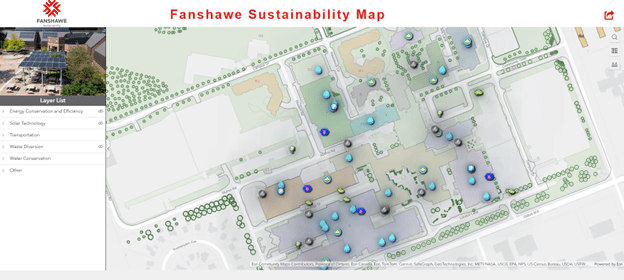
Fanshawe College Sustainability Interactive Map
Efficient Campus Space and Utility Management
ArcGIS Enterprise helps universities manage their facilities more effectively by providing tools for asset tracking, maintenance scheduling, and utility management. ArcGIS Indoors, an indoor mapping solution, is particularly useful in this regard. It allows facility managers to create interactive indoor maps that help in tracking maintenance activities, managing space reservations, and navigating large campus buildings. ArcGIS Utility Network offers comprehensive tools for managing, modeling, and analyzing complex utility systems, including water, electricity, gas, and telecommunications.
Case Study: Harvard University
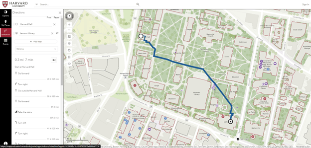
Harvard University's Indoor Viewer
Embracing ArcGIS Enterprise/ArcGIS Online for a Smarter Campus
As seen in the examples above, ArcGIS Enterprise, along with other Esri products and services including ArcGIS Online, offers higher education institutions a powerful suite of tools to enhance campus planning and management by optimizing their operations and creating a more efficient and collaborative campus environment. ArcGIS provides tools to facilitate importing, georeferencing, and managing CAD files for campus datasets. Additionally, with ArcGIS Enterprise, other campus asset management tools and user-managed databases can be integrated to create a comprehensive and interconnected campus management system. Both ArcGIS Enterprise and ArcGIS Online also facilitate data sharing and collaboration among different departments, administrators, and community members. The broad range of applications and mapping services available in either ArcGIS Online or ArcGIS Enterprise facilitates the process of developing apps and maps for stakeholder and public engagement so that decisions are made more effectively. For example, ArcGIS Enterprise Sites or ArcGIS Hub in ArcGIS Online can help universities create websites and initiatives to share data, gather feedback, and foster community involvement.
Esri’s Education Program includes ArcGIS Enterprise and other products for administrative use. Explore the apps linked above to see how ArcGIS can transform your institution’s campus planning and management. Contact us at highered@esri.ca to find out if your institution already has administrative use licenses or for a consultation or visit our website (esri.ca) to learn more about our solutions.