Esri and 3D
It is predicted that there will be 8.5 billion people on Earth (United Nations, 2015) and 125 billion connected objects (IHS Markit, 2017) by 2030. We will soon be overwhelmed by a tsunami of data. To respond to increasingly complex issues in an interconnected world, we, as GIS professionals, infrastructure managers, civil engineers, planners or architects, must make sense of all this data, because what will certainly not change is the number of planets available to accommodate these humans and these objects. Now, if I ask the question: Why does Esri do 3D? The answer is simple; our world is in 3D.
The value of 3D
3D enables a more precise representation of the real world and even enables visualization of objects that are fictitious or that are not visible until they have been represented in 3D. Think of representations of what is underground or of the distribution of what is not visible to the naked eye, but which is indeed present. Thus, 3D makes it possible to reveal phenomena that would not be possible in 2D. Also, when sharing and communicating information with a non-technical audience, 3D can be much more meaningful. A stunning app to discover, created by Raluca Nicola with the ArcGIS API for JavaScript, enables you to watch earthquakes from inside the Earth. Explore the app here and learn more about the ArcGIS API for JavaScript here.
Animation of a representation of what is underground
Be a visionary
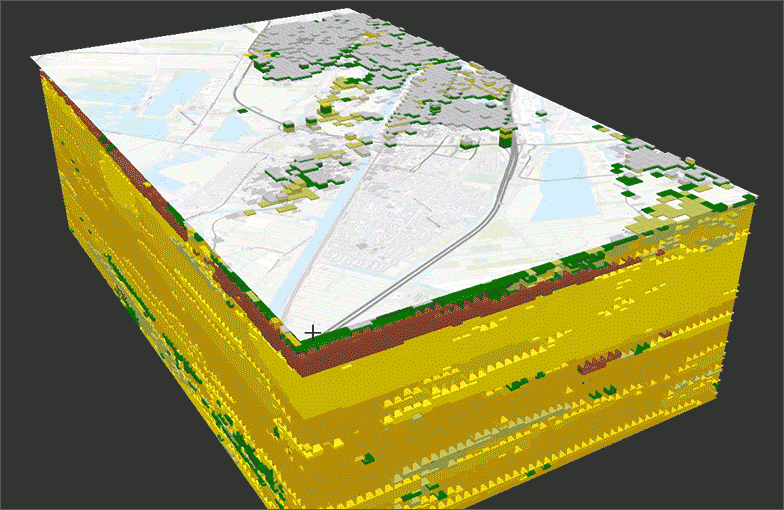
We have access to a plethora of new data. The image shown below represents certain forms that 3D data can take. Be a visionary, it is now possible to use context from the real world to analyze phenomena, plan emergency measures, create simulations and understand the impacts of the change. 3D enables the ability to bring conceptual ideas in the context of reality and effectively communicate the analysis results to decision makers and to the public for a more informed decision.
Different forms that 3D data can take
How to make sense of these data?
A 3D interoperable platform with 3D capabilities is the visionary tool we need. Such a platform has the following characteristics : Interoperability between BIM and GIS technologies, enrichment of the data, 3D analysis, performance of the processing and classification of big data such as scatter plots, quality of visualization and 3D immersive views and finally, the ability to share and collaborate.
Subsequently, let’s have a closer look at what the ArcGIS platform has to offer with 3D.
BIM and GIS Interoperability: What’s New
Two new tools will be available with ArcGIS Pro 2.5. The first geoprocessing tool, BIM File to Geodatabase, will allow the addition of multiple Revit files as input in order to obtain, as output, a geodatabase that you will be able to enhance using geoprocessing tools to do spatial analysis of your data, with additional data sources, as well as editing your data. The second tool, Create Building Scene Layer, will allow you to generate a scene layer package based on the geodatabase created using the aforementioned geoprocessing tool.
3D Analyst toolbox: What’s New
Several improvements for the LiDAR data classification tools are on the menu. When the time comes to classify the points representing the buildings, we often encounter significant obstacles. Think of the noise created by the large glass towers of central business districts. It is now possible to adjust the noise level and identify the small elements that are under and on the roofs (e.g. vegetation, ventilation, etc.).
Regularization of the footprint
The options are within reach for regularizing the building footprint with the ability to process complex shapes. The current right angle or diagonal options are too restrictive, while the variable angle option is too flexible for editing buildings. We now have the ability to take the variable angle option while favouring the right angles - the best of both worlds. In addition, to make it all faster, you can take advantage of the benefits of a graphics processor.
The use of raster data layers to define point classes representing water or vegetation is a powerful function. For example, water is an unpredictable surface. With water, you never know whether you will get a return since LiDAR uses infrared as a wavelength and water absorbs infrared! Let’s not forget the consequences of reflection, water property which returns the return almost everywhere except to the sensor placed on the plane. Also, if the return succeeds in finding its way back to the sensor, the signal is often confused with that of the ground, because it is equally horizontal and flat. This ability to use a matrix data layer for defining the water class is therefore very useful.
Furthermore, ground point classification is now eight to ten times more effective in terms of speed of execution. This is great news for those who produce digital terrain models!
Finally, editing the TIN improves with the advantages drawn from the topology and from the interactive tool allowing to reverse the TIN segment and to connect the nodes.
Scene Viewer: What’s New
For viewing and sharing data and analysis results, Scene Viewer is the ideal tool to activate navigation beneath ground level. Improvements to the app include faster viewing and rendering as well as researching features. The 3D views are immersive and intuitive. You can contextualize and communicate your decisions by creating customized popup windows with the built-in mesh scene layers. You can also view your scatter plots directly in the Scene Viewer or publish your digital field model obtained from LiDAR data in ArcGIS Pro and use the web service in the Scene Viewer for a finer topography. Finally, the Widget 3DFx available in Web AppBuilder for ArcGIS enables you to animate your point, linear or surface data from a 3D scene, in a 3D environment.
To view the new capabilities in ArcGIS Pro 2.5 (coming in February 2020), watch this Esri video: What’s New in ArcGIS Pro 2.5.
Conclusion
In conclusion, let’s go back to our initial question: Why does Esri do 3D? Well, the answer is simple: because our world is in 3D and the challenges we face come from the world. By providing people with 3D information, we provide a close to real time context and reveal new perspectives that will help them to understand, absorb and capture the information. But don't take my words for granted. Explore the ArcGIS platform 3D features and let me know what you think by leaving your comments below.
This post was originally written in French by Audrey Beaudoin-Arcand and can be viewed here.