Real-world uses for ArcGIS Data Reviewer Checks
Ask a GIS professional what keeps them up at night, and there’s a good chance they’ll say bad data. Even the best maps and analyses are only as good as the data behind them. That’s where the extension in ArcGIS Pro called Data Reviewer comes in. In this blog, we’ll explore the basics of Data Reviewer and share real-world scenarios of how Data Checks can help improve data quality across a variety of industries.
Whether you’re creating information products, supporting decision-making or performing spatial analysis, the quality of your results depends on the quality of your data. ArcGIS Data Reviewer helps organizations maintain accurate and reliable datasets by identifying errors and enforcing data quality standards.
Data Reviewer comes with a variety of quality control tools that make reviewing data faster and more consistent. It includes both automated and semi-automated tools to help identify feature errors quickly and efficiently. One of the great things about Data Reviewer is the library of no-code, ready-to-use checks based on attribute rule workflows. These checks can be configured with specific conditions to ensure they align with your organization’s unique business requirements. If you like visuals, this online poster displays the ArcGIS Data Reviewer checks.
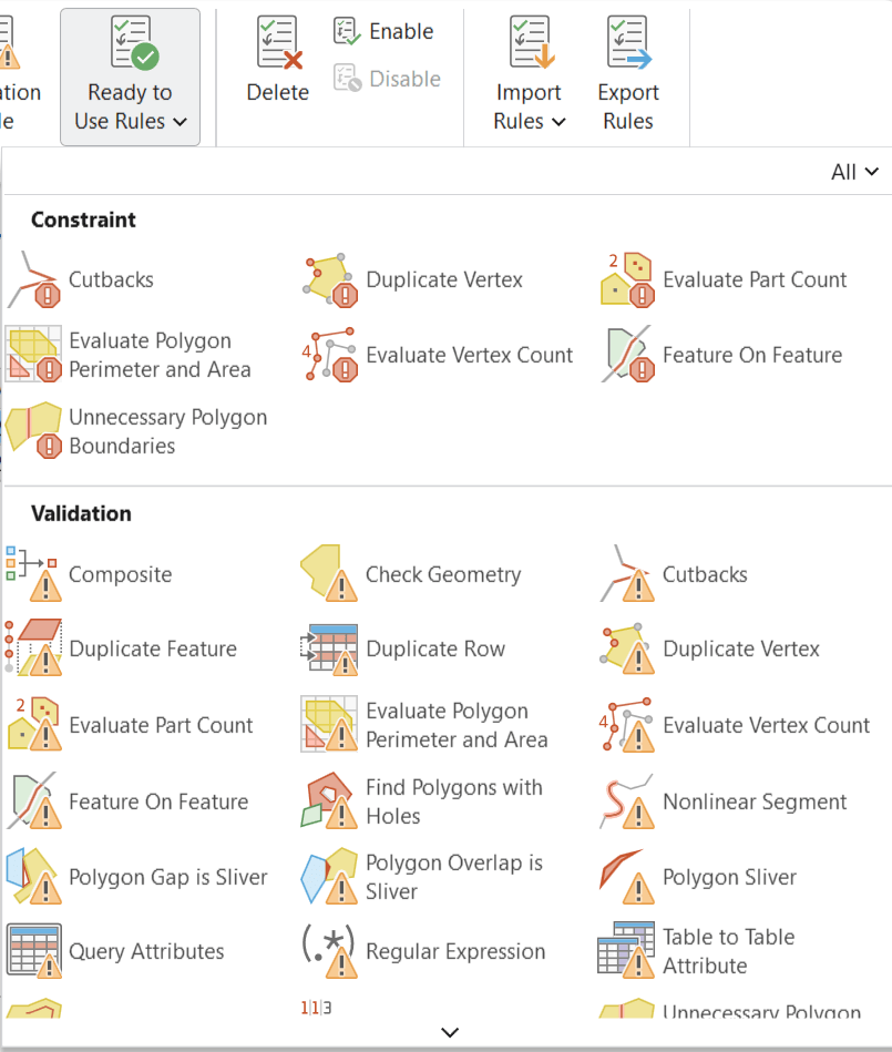 Some of the Ready to Use Rules in Data Reviewer
It’s important to note that while these checks are available through the Data Reviewer extension, some require a minimum license level of ArcGIS Pro Standard. Refer to the documentation for each check to determine the licensing requirements and confirm that you have access to the functionality you need.
Data Reviewer Checks and industry examples
Below you'll find a list of Data Reviewer Checks and industry examples of when and where these would be useful. These examples are intended to spark ideas and demonstrate how the same check can be applied across multiple industries and business workflows.
Feature on feature
Purpose: Finds features that have a specific relationship either between two features layers or within the same feature layer.
Why it matters: Many datasets rely on features being properly located relative to one another. Invalid spatial relationships can lead to analysis errors.
Industry examples:
- Utilities – Verify hydrants are located within the appropriate service area boundaries.
- Address Management – Site addresses and municipal boundaries.
- Indoor GIS – Rooms and floor footprints.
Find dangles
Purpose: Finds polyline features with nodes that are within a user defined tolerance but not connected to other polyline or polygon features.
Why it matters: Disconnected network features can negatively impact routing, tracing and things like network analysis. Identifying dangles helps maintain the integrity of connected systems.
Industry examples:
- Water Utilities – Water mains and distribution networks.
- Transportation – Road centerlines and transportation networks.
- Environmental & Natural Resources – Wildlife corridors and habitat links.
Event on event
Purpose: Finds linear referenced events that overlay other events based on a user-defined relationship.
Why it matters: Organizations often have rules governing which events can or must occur together. This check helps ensure compliance with operational, engineering and regulatory requirements.
Industry examples:
- Transportation – School zones and speed limit events.
- Oil & Gas – Gathering lines and approved product types.
- Emergency Management – Evacuation routes and road closure events.
Different z at intersection
Purpose: Finds two intersecting line features whose z-value difference is within the minimum/maximum specified range at the point where they intersect.
Why it matters: Accurate elevation data is critical for 3D analysis and infrastructure management. This check helps identify incorrect elevation relationships between connected features.
Industry examples:
- Mining – Haul road networks and road elevations.
- Municipal Infrastructure – Pedestrian pathways, tunnels and bridges.
- Aviation – Ensure taxiways and runways connect at an appropriate elevation.
Relationship
Purpose: Finds rows in feature classes and stand-alone tables that violate cardinality or relationship rules defined in a Relationship class.
Why it matters: Organizations rely on relationship classes to connect assets, inspections, permits, maintenance records and other critical information. Missing relationships can lead to incomplete reporting and poor decision-making.
Industry examples:
- Local Government – Playgrounds and inspections.
- Environmental Management – Habitat areas and management plans.
- Public Health – Clinics and operating licenses.
The examples in this blog are just a small sample of what’s possible with ArcGIS Data Reviewer. The purpose was to spark ideas about how the extension can support your organization’s data quality goals. Every map, dashboard, analysis and decision begins with data, and the quality of those outputs can only be as good as the data behind them. Investing time in data quality today can prevent costly error tomorrow. With ArcGIS Data Reviewer, you can proactively identify issues and enforce standards. This means that you can build greater confidence in your data, helping ensure that the information your organization relies on is trustworthy and ready for action!