Future-Ready Approach to Dam Safety Risk Decisions at BC Hydro
Faster risk decisions and safer dam operations with GIS. See how BC Hydro unified data, models and monitoring across 82 dams and a century of records.
View
Faster risk decisions and safer dam operations with GIS. See how BC Hydro unified data, models and monitoring across 82 dams and a century of records.
View
Esri Canada’s Getting Technical blog post brings you the latest and most significant news about Esri technology.
View
In this episode of Getting Technical, explore the latest AI features in ArcGIS, including GeoAI, AI assistants, agentic workflows, Trusted AI and new developer tools.
Watch Video
Just getting started with ArcGIS Pro? Use these tips and strategies from certified ArcGIS instructor Oscar Andrade-Rios to guide your learning.
View
In this webinar, we’ll demonstrate the newest capabilities in ArcGIS Pro 3.5 and 3.6, focusing on practical workflows that make analysis, visualization and data management faster and more intuitive. W
Watch Video
ParcelMap BC, developed and maintained by the Land Title and Survey Authority of BC, is the trusted land management system mapping more than two million parcels for use by governments, utilities and o
Watch Video
Discover how Fathom Studio blends geographic information systems (GIS) and artificial intelligence (AI) to power better planning, improve decision‑making and shape the future of community design.
Watch Video
A clear overview of what you need to know before upgrading an enterprise geodatabase, including versioning, client compatibility and planning considerations.
View
Learn how Blue Sky Net improves broadband access, empowering municipalities and preserving infrastructure knowledge through GIS across Northern Ontario.
View
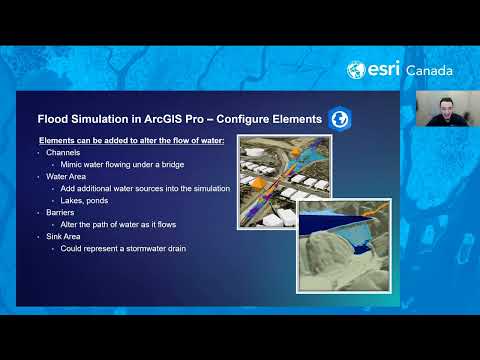
In this webinar, we’ll explore practical workflows for visualizing flood data and creating interactive maps that illustrate potential flood extents and impacts. You’ll learn how ArcGIS Solutions can a
Watch Video
How geospatial tools help Canadian communities reduce wildfire risk, especially in the WUI, before flames arrive.
View
Esri Canada’s Getting Technical blog post brings you the latest and most significant news about Esri technology.
View
From grade nine geography to applied geomatics, discover how GIS expanded the world for Aidan Hawkins and guided him toward a career in mapping.
View
Learn why exporting large feature layers from ArcGIS Online can result in empty zip files and how to fix the issue using ArcGIS Pro.
View
Here is a list of your favourite GeoSnaps and some of our most recent videos that should be on your watch list.
View
ArcGIS Desktop retires on March 1, 2026. Learn why migration to ArcGIS Pro and user types is essential for advanced GIS capabilities and security.
View
Digital Twins help municipalities improve planning, coordinate growth, and support housing and infrastructure decisions.
View
What’s Making Us Mappy with Catherine-Anne Currie – ArcGIS Pro 3.6
Watch Video
ArcGIS helps municipalities meet Housing Accelerator Fund goal with scenario planning, site analysis, dashboards, and community engagement solutions
View
Esri Canada’s Getting Technical blog post brings you the latest and most significant news about Esri technology.
View
Loading More...