From paper to pixels: bring your property sketches into the GIS era
Still using paper sketches? It’s time to draw the line. Digitize, integrate and unlock smarter property insights right inside your GIS.
Still relying on paper sketches, or worse, missing sketches altogether? You're not alone. But you're also not stuck. Sketch creation is your fast track to cleaner, smarter and more accurate property data.
Whether you're digitizing old documents or starting fresh with new outlines, sketch creation takes raw or missing information and turns it into spatially accurate digital drawings, ready to live, breathe and work inside your GIS environment.
What is Sketch Creation?
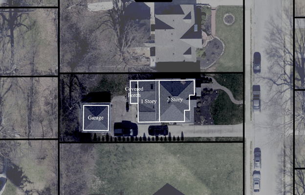
At its core, sketch creation is the process of building GIS-ready property sketches with the ability to sketch multiple floors and it works in two big ways:
-
- Converting the old by turning paper-based sketches (or PDF scans) into Esri Feature Class files that integrate directly into your GIS.
- Creating the new so when no sketch exists, one can be built from scratch with a combination of aerial and/or oblique imagery.
Every sketch is spatially aligned, accurately measured and formatted for consistency. No more hand-drawn confusion or missing square footage.
Why it matters
Sketches aren’t just illustrations, they’re data. And when they’re built into your GIS, they unlock serious value:
-
- Better valuations are derived from clean, consistent outlines = fewer errors and more reliable assessments.
- Smarter Field Work where inspectors and appraisers head out with accurate, up-to-date sketches.
- Share the data with cross-team collaboration so that everyone can have access to the sketches right at their fingertips whether the permitting, planning, or development teams.
- Sketches are fully integrated into the GIS, ready to be queried, mapped, or visualized.
And because sketches are stored in Esri Feature Classes, they plug into your existing GIS workflows. No extra tools, no messy conversions.

Who’s it for?
These converted sketches are for everyone, from assessment offices modernizing old records to appraisal teams seeking reliable data, planning departments needing accurate building outlines, or anyone simply tired of digging through dusty old files.
Sketch creation isn’t just digitizing for the sake of it, it’s about building a trusted spatial foundation. Clean data in, better decisions out.
Ready to upgrade your sketches? Let’s draw the line, literally.
Learn more about Sketch Creation and how it can streamline your property data workflows.