Bringing History to Life: How StoryMaps Help Students Connect with WWI
Students often see history as something that happened a long time ago, somewhere far away, involving people they have no connection with. Digital storytelling can bridge the gap between students and the past. Discover how Bluewater District School Board educators Jennifer Morris and Hillary Weppler use ArcGIS StoryMaps to help grade 10 history students connect with WWI history, their families and their region of Grey County in meaningful ways.
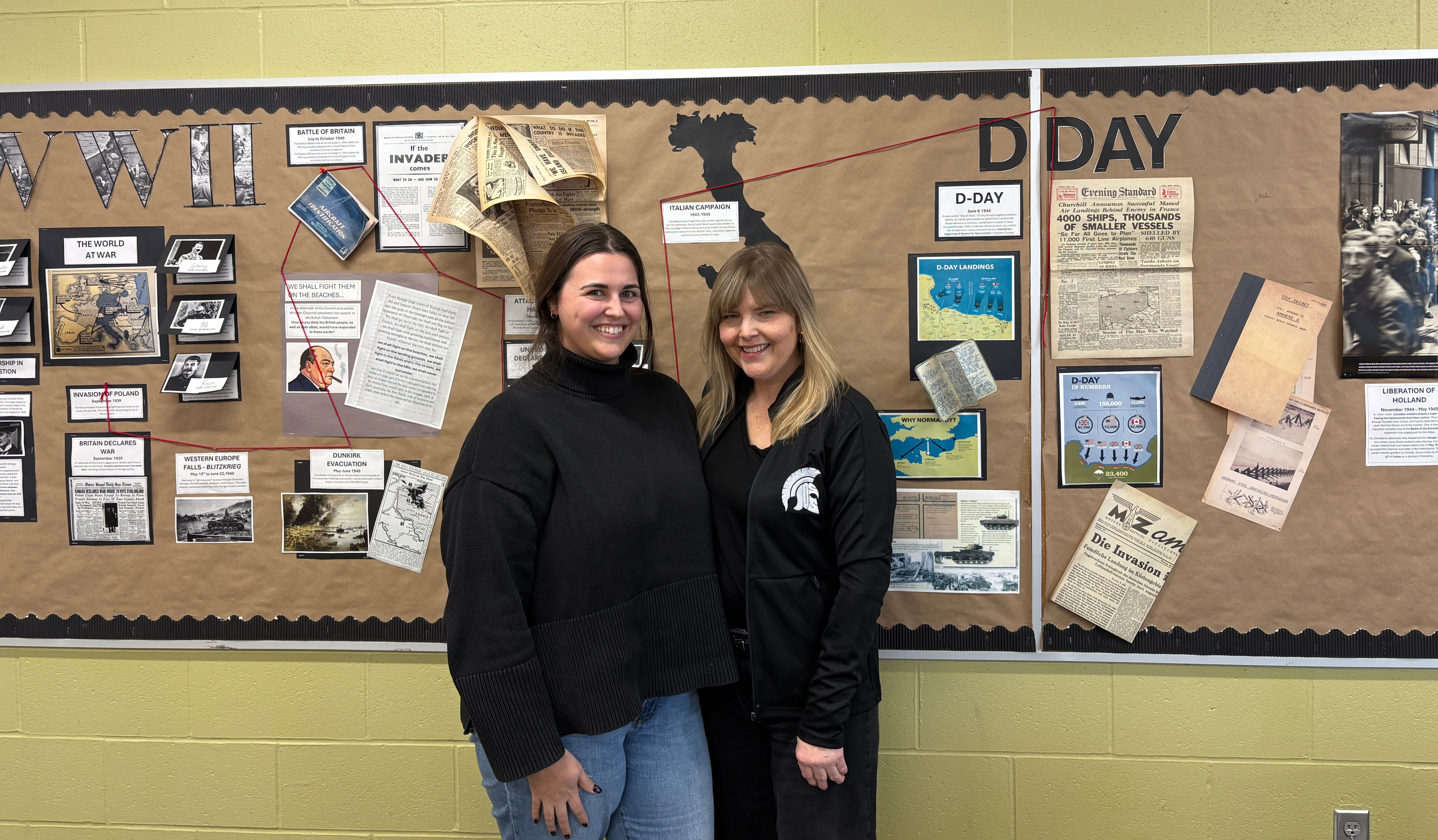
I recently met with Jennifer and Hillary to learn more about their WWI project, and their enthusiasm was evident. Our conversation was lively and engaging as they walked me through the evolution of their work and the impact it had on their students. It was no surprise to learn that in 2025, they were finalists for a Governor General’s History Award for Excellence in Teaching as they were recognized for their innovative WWI project. Some of their students’ storymaps are featured in an online exhibit called “Bringing History to Life” from Grey Roots Museum and Archives.
“Spatial thinking is a critical skill, yet it’s often underdeveloped in traditional classrooms. Storymaps are valuable for teaching and learning because they help students see relationships between places, people, time, and events. It shifts students from consuming information to interpreting and constructing meaning. “ – Hillary Weppler
As we began our conversation, I asked Jennifer what led them to choose StoryMaps for this project.
“We chose StoryMaps because it aligned naturally with our learning goals. We wanted students to understand WWI not just as a series of events, but as lived experiences shaped by geography, movement, and human decision-making. StoryMaps allowed students to integrate narrative, primary source research, and spatial thinking in one cohesive platform.
The presentation tool structured and enhanced student thinking. Students now had to consider where events happened, how movement influenced outcomes, and how to tell a story that connected time and place. That combination deepened both their historical understanding and their engagement.“
Jennifer's explanation set the stage for understanding how the project evolved into something far more powerful than a traditional research assignment.
How the Project Began
The idea of using StoryMaps for the “Personnel File” project first emerged in 2023. Jennifer, a history teacher from École John Diefenbaker Senior School in Hanover, Ontario had long used primary sources to help students build research skills, and the personnel files of Canadian WWI soldiers from Grey County were the foundation of that work. In earlier versions of the project, students created posters profiling their chosen soldier. The project was good, but Jennifer wanted her students to get more out of it.
Recognizing this opportunity, she reached out to Hillary, a technology coach from her school board to explore possible digital tools that could improve the project. Hillary, drawing on her experience with ArcGIS software, suggested StoryMaps as a possibility. The two colleagues tested the idea by using a sample personnel file, mapping the soldier’s movements from recruitment to overseas deployment. Almost immediately, they saw how the tool transformed static documents into a vivid, unfolding story. The places became real and the distances became tangible. The soldier’s experience became something students could follow step by step.
They realized StoryMaps could bring history to life in a way that resonated with today’s learners.
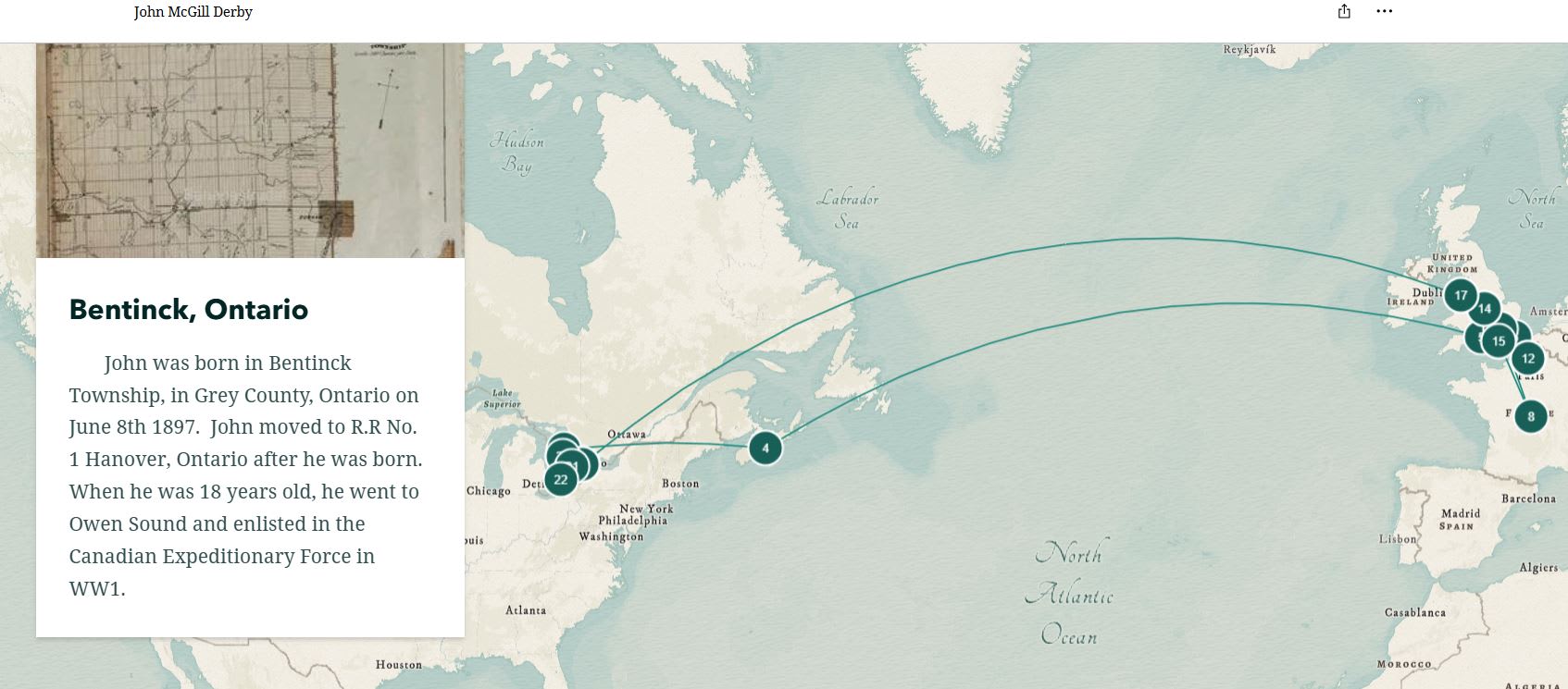
Explore John McGill Derby's StoryMap created by student Lily B. “Back to France - from February 27th, 1918 to the end of the war. John was involved In the German Offensive (Operation Michael) and the Last 100 Day's on November 11th (Armistice)."
StoryMaps Matter for Youth Engagement
This approach works because it mirrors the way young people already interact with information online. Instead of reading about battles in abstract terms, students can see where events happened and how far soldiers travelled. Instead of memorizing dates, they can follow a timeline that unfolds across a map. Instead of viewing soldiers as anonymous names, they can explore the lived experiences of individuals who once belonged to their own communities.
This approach also supports deeper inquiry. It encourages students to ask questions: What was happening in this location at that time? How did terrain shape the soldier’s experience? What might it have felt like to move from a small Canadian town to the trenches of Europe?
These questions lead to richer research, stronger empathy, and a more personal connection to the past.
What Students Experienced
As Jennifer and Hillary shared stories from the classroom, it became clear how transformative the project had been. Students shared their experiences of learning about WWI soldiers from the Grey County region:
“We had the (soldiers’) letters, but we never mapped out where he went or what he did there. So, when we got to put it on a map and see all the places he went to, we realized he travelled extremely far. He was a trainer that travelled all over Canada before he even went to Europe. We got to see snippets of what was happening on the map.”
- Scott P (This student mapped their great-great uncle who was a trainer in WWI).
“When I presented my grandmother the files (map) of her great uncle, she cried and was stunned because no one has ever brought to light what he did for the world. She thought it was brilliant, and she got to see what her family actually did for this country.”
- Scott P
“It helped me understand the soldiers more, because you’re learning from a person’s point of view instead of just a textbook. It really made me connect with them more and have more emotions connected to it”
- Lily B
These experiences show how digital storytelling can turn historical research into a deeply personal journey for some students.
A New Way Forward for Local History
By integrating StoryMaps into the Personnel Files project, Jennifer and Hillary have created a model for how educators can use technology to deepen historical understanding. The storytelling tool doesn’t replace traditional research, it enhances it. Students still analyze documents, interpret evidence, and construct narratives. But now they also visualize journeys, contextualize events geographically on a map, and engage with history in a way that feels real and not just a story.
This blend of primary source research and digital storytelling helps students see WWI not as a distant chapter in a textbook, but as a story rooted in their own families, communities and country. It reminds them that history is made by real people who lived, hoped, struggled, and sacrificed.
What’s next for Jennifer and Hillary
As our conversation wrapped up, Jennifer shared how this work is shaping their future teaching.
“In 2026, we’re applying this approach to an Ancient Civilizations course, again centering inquiry and the historical thinking concepts. We see mapping as a way to help students explore cause and consequence, continuity and change, and historical significance in a visual and interactive way.
Our focus is on how students can use the tools to investigate patterns, analyze evidence, and build interpretations, rather than simply presenting information. We want the technology to deepen their historical reasoning and make the past feel dynamic and connected.”
– Jennifer Morris
Their next steps show how digital storytelling can evolve across subjects, grade levels, and historical eras continuing to help students see themselves in the stories of the past.
Thank you, Jennifer and Hillary, for sharing your reflections on this project. Your passion for teaching and your commitment to fostering inquiry and historical thinking makes learning meaningful and interactive for students. We look forward to seeing how your future projects continue to grow.
Explore different ways StoryMaps are used in K-12 education
On the Map with Sarah Gallah
Meet Sarah Gallah, a high school educator with a passion for bringing geography and science to life using ArcGIS StoryMaps.
Skills Ontario 2025: Students map crime patterns in Ottawa
Read this blog post to learn how Ontario students are putting their ArcGIS knowledge to the test by addressing real-world issues at the annual Skills Ontario GIS competition. Each team of two present their findings in a StoryMap to the judges and fellow participants.